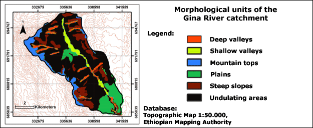
The Gina River catchment can be divided into six different morphological units. The determining factors are slope inclination and elevation:
Plains: In the Plains slope inclination is, in general, less than 3 %. Thus, significant changes in altitude do not occur. This morphological unit is located mainly in the southern part of the catchment area and around the village of Mesho.
Undulating areas: The Undulating areas show a complex hilly structure. Only at some locations does slope inclination increase up to 20 %. This unit covers more than half of the Gina River catchment.
Steep slopes: Steep slope areas are characterised by a strong relief. They frame mainly the Mountain tops.
Mountain tops: This morphological unit is defined by its high elevation (above 3000 m a.s.l.). Slopes are mostly gentle to almost flat. These areas are located at the divide.
Deep valleys: This unit is characterised by channels with steep, perpendicular river banks. Water is running throughout the year. Deep valleys occur along the lower course of the Gina River tributaries.
Shallow valleys: This morphological unit shows gently sloped river banks. Shallow valleys occur along the Gina River (Beck et al. 2004).