Rainfall-runoff Modelling
Some results of the rainfall-runoff modelling presented by the runoff-precipitation quotient show plausible values (see figure). However, the variations of data between the sub-basins can indicate that the quotients can only reflect the overall characteristics for the individual sub-basins, but not describe the complex character so that water balance can be compared.
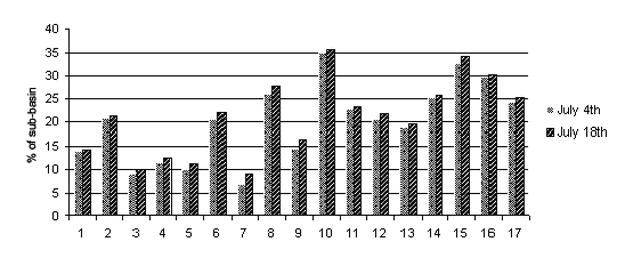
Gina River sub-basins: Runoff-precipitation quotient; adapted from Beck et al. 2004.
This can be attributed to insufficient input data (Curve Number and the percentage of impervious area). Thus, the results do not allow any comparison to the distributed soil erosion risk estimation (Beck et al. 2004). The mapped soil erosion damages are aligned to the investigated landscape factors and in this way the most relevant factors entailing soil erosion risk were identified.
How can now the soil erosion risk assessed?