Identify Watershed Problems

The Watershed Management planning process - step identifying and anlysing watershed problems
Image Credit: after data from Heathcote 1998
General aspects of this step
The next stage of the planning process is to identify concerns and problems that occur in the watershed and may interfere with its functioning. The problem types that have to be considered in terms of problem identification and analysis are shown in the following figure:
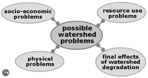
Problem types that have to be considered in this planning stage. after data from Tidemann 1996.
Some of them may be evident, others have to be disclosed by more detailed investigation or consultations with the local population, or may emerge by comparison with desired watershed conditions (Heathcote 1998).
Watershed problems in the Gina River catchment
In the Gina River catchment the main problem is soil erosion as the investigation of the drainage basin revealed. Talus edges, rill erosion, sheet erosion, gully erosion, mass movements and badlands are widely spread throughout the Gina River catchment. Soil erosion processes are due to several physical and man-made factors here, including steep slopes, heavy rainfalls and intensive human activities (e.g., cultivation, pasture even in areas with steep slopes) resulting in high soil compaction. Soil conservation measures are not sufficient to reduce soil erosion processes. Soil erosion is a severe problem as it threatens livelihood security. Having identified and analysed the problems of the watershed, clear and specific objectives have to be identified.