Department of Earth Sciences
Service Navigation
North of Labeatis Fossae – Sculpted by Nature
Image data by the High Resolution Stereo Camera (HRSC) on board ESA’s Mars Express mission show the tectonic features in the Ascuris region of Mars, north of Labeatis Fossae. HRSC is a camera experiment that was developed and is operated by the German Aerospace Center (Deutsches Zentrum für Luft- und Raumfahrt; DLR).
» read more in the main article and below the gallery about the region north of Labeatis Fossae ...
Labeatis Fossae • Location and Scheme

Context map
Image Credit: MOLA Science Team/FU Berlin

Scheme for the formation of horst and graben system
Labeatis Fossae • Images

HRSC color image
Image Credit: ESA/DLR/FU Berlin

HRSC color-coded terrain model
Image Credit: ESA/DLR/FU Berlin

HRSC anaglyph
Image Credit: ESA/DLR/FU Berlin
North of Labeatis Fossae – Sculpted by Nature
» read more about the region north of Labeatis Fossae
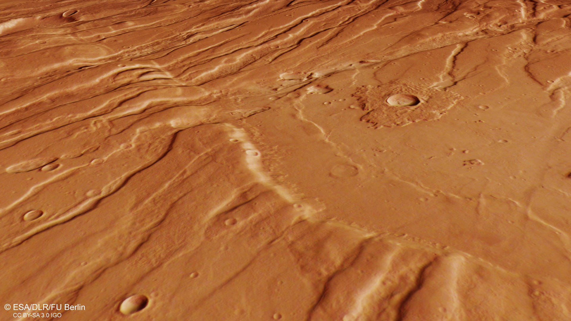
A breathtaking view of the fractured Martian surface displays the tremendous force that acted on the crust. Located northeast of the Tharsis volcanic province, the region is a prime example for so-called horst and graben structures, that were also featured nearby in Ascuris Planum (PR July 2015). This time however, different lighting conditions, a consequence from Mars Express’ unique elliptical orbit and different observation times result in a magnificent artwork of nature.
How are horst and graben structures created?
The region shown on the HRSC images shows a so-called horst and graben tectonics, as in the textbook. If a rigid, brittle rock crust is stretched, for example because the ground is raised, the surface above it comes under tension. If the strain stress rises above the limits "bearable" for the rock, the crust breaks up along more or less steeply falling fracture surfaces: A "fault zone" is created. If the crust continues to expand, large blocks of rock slide along the fracture surfaces for several hundred metres, in some places even one to two thousand metres into the depths: over many millions of years, a tectonic trench develops. The blocks left standing on both sides now tower above the landscape and form the associated nests. The word pair "horst and graben" has its origins in early medieval miner's German and was adopted into the language after geology was established as "earth science". It is also used in this wording in other languages.
During the slow buildup of the Tharsis bulge which stretches over several thousand kilometers and rises five kilometers above the surrounding plains, the stress in the crust lead to multiple extensional fractures and also recorded changes in the stress direction. Numerous faults and ridges running perpendicular to the main direction can be found in the southern (left) part of the plan view image.
The landscape in the northern pat of the image (right) shows a much smoother profile. The grabens appear partly filled and in the upper part of the image, so-called wrinkle ridges can be found. They develop through cooling and solidification of lava and point to the very deep reaching fractures in this region.
High Resolution Stereo Camera (HRSC)
» information to image origin and processing
The images were acquired by the HRSC (High Resolution Stereo Camera) on 30 September 2019 during Mars Express Orbit 19913. The ground resolution is approximately 15 meters per pixel and the images are centered at about 279° East and 36° North. The color image was created using data from the nadir channel, the field of view which is aligned perpendicular to the surface of Mars, and the color channels of the HRSC. The oblique perspective view was generated from the digital terrain model, the nadir and color channels of HRSC. The anaglyph, which provides a three-dimensional view of the landscape when viewed using red-green or red-blue glasses, was derived from data acquired by the nadir channel and the stereo channels. The color-coded topographic view is based on a digital terrain model (DTM) of the region, from which the topography of the landscape can be derived. The reference body for the HRSC-DTM is a Mars equipotential surface (Areoid).
HRSC is a camera experiment that was developed and is operated by the German Aerospace Center (Deutsches Zentrum für Luft- und Raumfahrt; DLR).The systematic processing of the camera data took place at the DLR Institute for Planetary Research in Berlin-Adlershof. The working group of Planetary Science and Remote Sensing at Freie Universität Berlin used the data to create the image products shown here.
To download released raw images and DTMs of the region in GIS-ready formats, follow this link to the mapserver.
Images: ESA/DLR/FU Berlin, CC BY-SA 3.0 IGO
Copyright Notice:
Where expressly stated, images are licenced under the Creative Commons Attribution-ShareAlike 3.0 IGO (CC BY-SA 3.0 IGO) licence. The user is allowed to reproduce, distribute, adapt, translate and publicly perform it, without explicit permission, provided that the content is accompanied by an acknowledgement that the source is credited as 'ESA/DLR/FU Berlin', a direct link to the licence text is provided and that it is clearly indicated if changes were made to the original content. Adaptation / translation / derivatives must be distributed under the same licence terms as this publication.
The High Resolution Stereo Camera was developed at the German Aerospace Center (DLR) and built in collaboration with partners in industry (EADS Astrium, Lewicki Microelectronic GmbH and Jena-Optronik GmbH). The science team, which is headed by Principal Investigator (PI) Prof. Dr. Ralf Jaumann, consists of 52 co-investigators from 34 institutions and 11 countries. The camera is operated by the DLR Institute of Planetary Research in Berlin-Adlershof.