Department of Earth Sciences
Service Navigation
Arcadia Planitia – Whirling Dust Devils in Colorful Martian Lowlands
Image data, taken by the High Resolution Stereo Camera (HRSC) on board ESA’s Mars Express mission show a part of Arcadia Planitia, located in the northern lowlands. HRSC is a camera experiment that was developed and is operated by the German Aerospace Center (Deutsches Zentrum für Luft- und Raumfahrt; DLR).
» read more in the main article below...
Arcadia Planitia • Position & 3D view

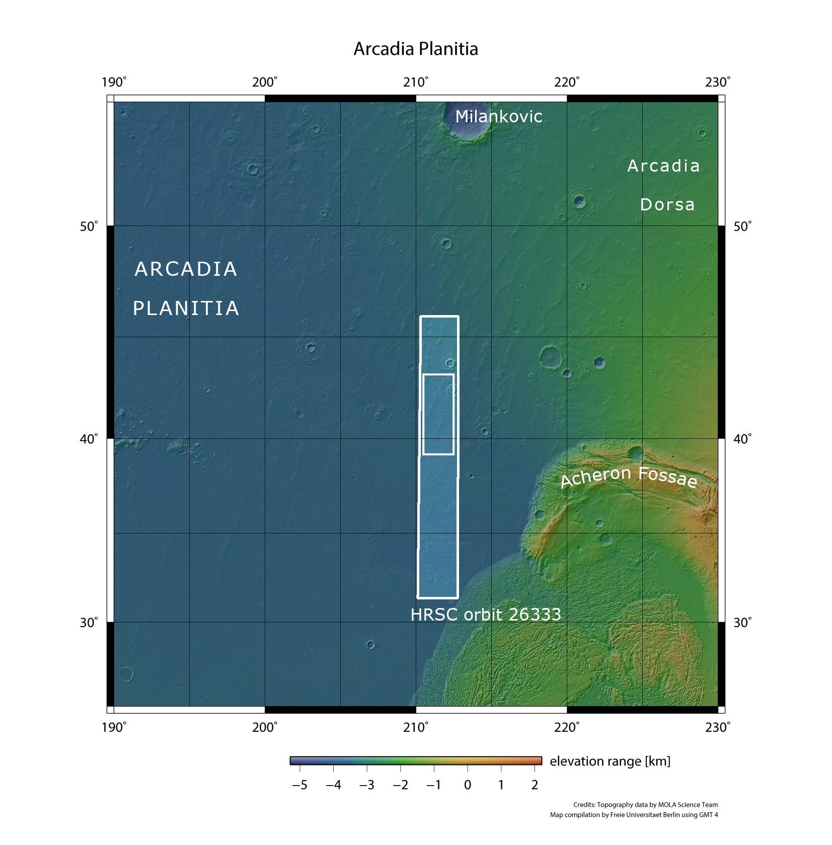
Arcadia Planitia - context map
Image Credit: MOLA Science Team/FU Berlin

Arcadia Planitia - 3D perspective 1
Image Credit: ESA/DLR/FU Berlin

Arcadia Planitia - 3D perspective 2
Image Credit: ESA/DLR/FU Berlin
Arcadia Planitia • HRSC images

Arcadia Planitia - HRSC color-coded terrain model
Image Credit: ESA/DLR/FU Berlin

Arcadia Planitia - HRSC color image
Image Credit: ESA/DLR/FU Berlin

Arcadia Planitia - HRSC annotated
Image Credit: ESA/DLR/FU Berlin

Arcadia Planitia - HRSC anaglyph
Image Credit: ESA/DLR/FU Berlin
Arcadia Planitia
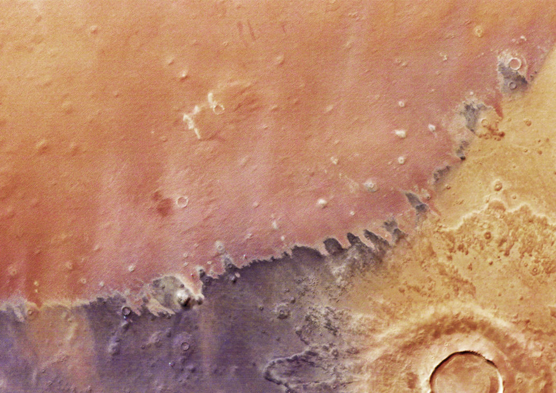
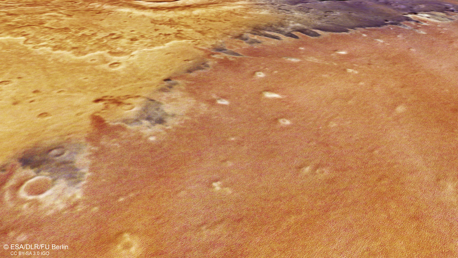
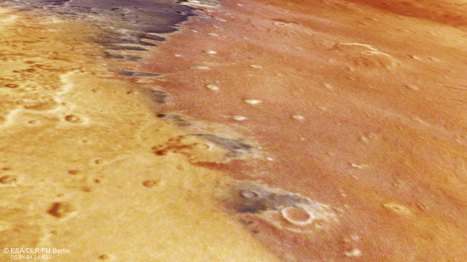
Arcadia Planitia is located in the northern lowlands northwest of the Tharsis province – a volcanic plateau home of the prominent Tharsis Montes shield volcanoes, including Olympus Mons. The plains of Arcadia exhibit relatively flat terrain and are predominantly characterized by volcanic flows dated to the Amazonian time period. The High Resolution Stereo Camera (HRSC) images show the eastern part of Arcadia Planitia and allow us to explore fascinating features such as whirling winds known as “dust devils”, volatile-rich ejecta blankets surrounding impact craters, and extensive yardang fields.

Schematic sketch of a dust devil
Mars has a very thin atmosphere – only about 1% as dense as Earth’s. Still, atmospheric phenomena like dust devils are widely observed on Mars. During just one orbit, HRSC captured four active dust devils, which are short-lived, localized whirlwinds – much smaller than large-scale dust storms. Dust devils typically form in the afternoon, when the heated Martian surface warms the air above it, causing the air to rise. The rising hot air creates a vertical vortex (whirlwind) that lifts dust and sand into the atmosphere. Through this process dust devils play a significant role in stirring up and distributing dust across the Martian surface.
In the HRSC images, dust devils appear as small bright spots with a trailing pinkish “shadow” (see annotated image). This shadow effect is caused by the dust devil’s fast motion during image capture. The HRSC imaging channels cover the same surface area at slightly different times: the nadir channel views vertically downward, while some channels view slightly forward and others slightly backward. This makes it possible to detect changes in the dust devil’s position and analyze its direction and speed.
On Mars, dust devils can reach speeds of up to 45 m/s and heights of up to 8 kilometers, though they are usually less than 100 meters wide. They are commonly found in broad plains like Arcadia Planitia – similar to their counterparts on Earth, which occur in dry desert landscapes. Despite the differences in atmospheric conditions, Martian and terrestrial dust devils share many similarities. However, those on Mars are often much larger, mainly due to large temperature differences caused by intense daytime heating.
At first glance, the image may appear slightly out of focus. Surprisingly, when zooming in, a field of yardangs reveals itself within the reddish-toned region – contributing to that initial impression of “blurriness” (see annotated image). These streamlined ridges are carved into bedrock or compacted sediment by persistent, unidirectional winds, which erode softer material more quickly than harder layers. The boundary between this yardang-rich, reddish area and the neighboring darker terrain is clearly defined – the darker surface lacks such features. The absence of yardangs there could indicate differences in surface composition, rock hardness, or variations in wind erosion intensity across the region. Aeolian processes, including the formation of yardangs, remain some of the most active geological forces on Mars today, particularly in low-lying areas like Arcadia Planitia, where wind continues to sculpt the landscape over time.
One prominent feature in the HRSC images is the ejecta blanket of an approximately 15-kilometer-wide impact crater (see annotated image). The lobate appearance of this ejecta blanket and the fact that it is double-layered is typical for a high volatile content in the target material. This kind of ejecta is called fluidized ejecta. Not only the morphology, but also spectral data of the ejecta show signatures of water-rich material, possibly excavated from shallow depths. The ejecta blanket looks well-defined, and the crater rim is not eroded, so the impact event must have happened relatively recently, speaking in terms of geological time scales. Fluidized ejecta blankets are pretty common in the mid-latitudes supporting the following climate suggestions for Mars.
A Martian climate model suggests that during periods of high obliquity (axis tilt), ice accumulation extended to the mid-latitudes – not only at the poles – and was later presumably covered by other material that protected it from sublimation. Since Arcadia Planitia is located in the mid-latitudes, the plains are known for the potential presence of ice near the surface, either in the form of excess ice (ice volume exceeding the total pore volume) or pore ice (ice within a matrix). Various geomorphological features in this region have been interpreted as ice-related. Due to the potential presence of water ice, some researchers have proposed Arcadia Planitia as a landing site for future robotic or human missions to Mars.
Read more about dust devils on Mars in the press release from 2019 and explore all press releases with the interactive map.
→ Who left the dark tracks on Mars?
High Resolution Stereo Camera (HRSC)
The images were acquired by the HRSC (High Resolution Stereo Camera) on November 10, 2024 during Mars Express Orbits 26333. The ground resolution is approximately 18 meter per pixel and the image is centered at about 211° East and 41° North. The color image was created using data from the nadir channel, the field of view which is aligned perpendicular to the surface of Mars, and the color channels of the HRSC. The oblique perspective view was generated from the digital terrain model, the nadir and color channels of HRSC. The anaglyph image, which creates a three-dimensional impression of the landscape when viewed with red/blue or red/green glasses, was derived from the nadir channel and one stereo channel. The color-coded topographic view is based on a digital terrain model (DTM) of the region, from which the topography of the landscape can be derived.
HRSC is a camera experiment that was developed and is operated by the German Aerospace Center (Deutsches Zentrum für Luft- und Raumfahrt; DLR). The systematic processing of the camera data took place at the DLR Institute for Planetary Research in Berlin-Adlershof. The working group of Planetary Science and Remote Sensing at Freie Universität Berlin used the data to create the image products shown here.
To download released raw images and DTMs of the region in GIS-ready formats, follow this link to the mapserver
Images: ESA/DLR/FU Berlin, CC BY-SA 3.0 IGO
Copyright Notice:
Where expressly stated, images are licenced under the Creative Commons Attribution-ShareAlike 3.0 IGO (CC BY-SA 3.0 IGO) licence. The user is allowed to reproduce, distribute, adapt, translate and publicly perform it, without explicit permission, provided that the content is accompanied by an acknowledgement that the source is credited as 'ESA/DLR/FU Berlin', a direct link to the licence text is provided and that it is clearly indicated if changes were made to the original content. Adaptation / translation / derivatives must be distributed under the same licence terms as this publication.
The High Resolution Stereo Camera was developed at the German Aerospace Center (DLR) and built in collaboration with partners in industry (EADS Astrium, Lewicki Microelectronic GmbH and Jena-Optronik GmbH). The science team, which is headed by Principal Investigator (PI) Dr. Daniela Tirsch, consists of 50 co-investigators from 35 institutions and 11 countries. The camera is operated by the DLR Institute of Planetary Research in Berlin-Adlershof.