Department of Earth Sciences
Service Navigation
Aonia Terra - Colorful Mars
Image data by the High Resolution Stereo Camera (HRSC) on board ESA’s Mars Express mission show an intriguingly colorful landscape in the Aonia Terra region of Mars. The High Resolution Stereo Camera (HRSC) is a camera experiment that was developed and is operated by the German Aerospace Center (Deutsches Zentrum für Luft- und Raumfahrt; DLR).
» read more in the main article and below the gallery about the Aonia Terra ...
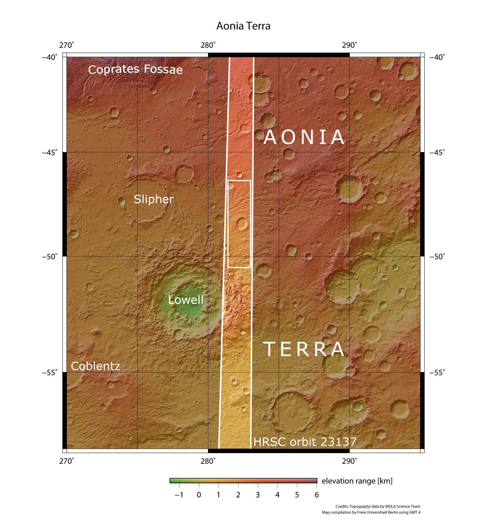
Aonia Terra • Position & 3D view

Aonia Terra 3D
Image Credit: ESA/DLR/FU-Berlin

Aonia Terra 3D_2
Image Credit: ESA/DLR/FU-Berlin

Aonia Terra map
Image Credit: MOLA Science Team/FU-Berlin
Aonia Terra HRSC images

Aonia Terra - color image
Image Credit: ESA/DLR/FU-Berlin

Aonia Terra color-coded terrain model
Image Credit: ESA/DLR/FU-Berlin

Aonia Terra anaglyph
Image Credit: ESA/DLR/FU Berlin
Aonia Terra - Colorful Mars
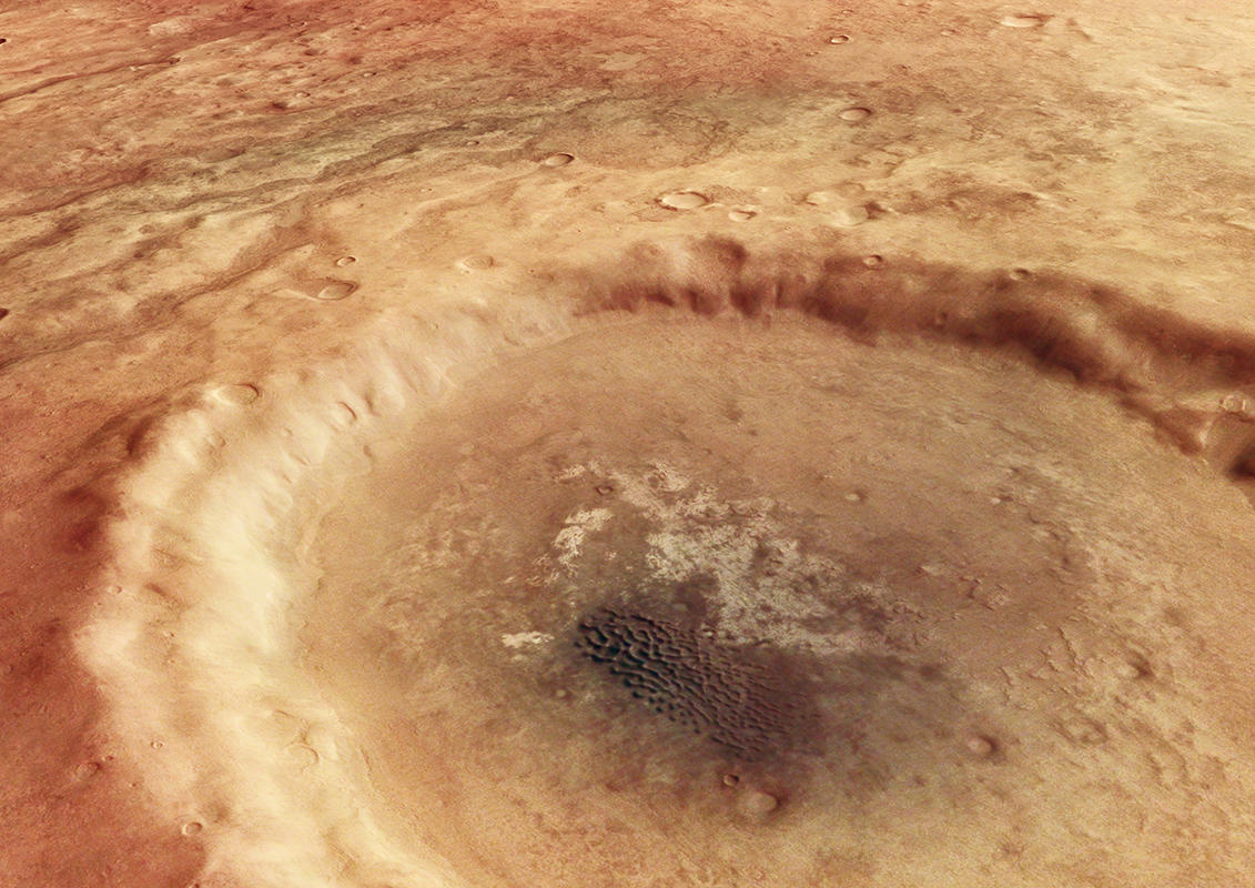
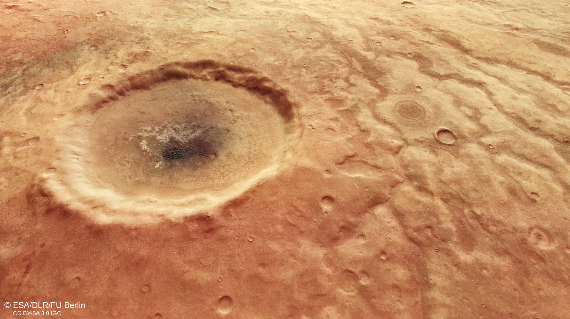
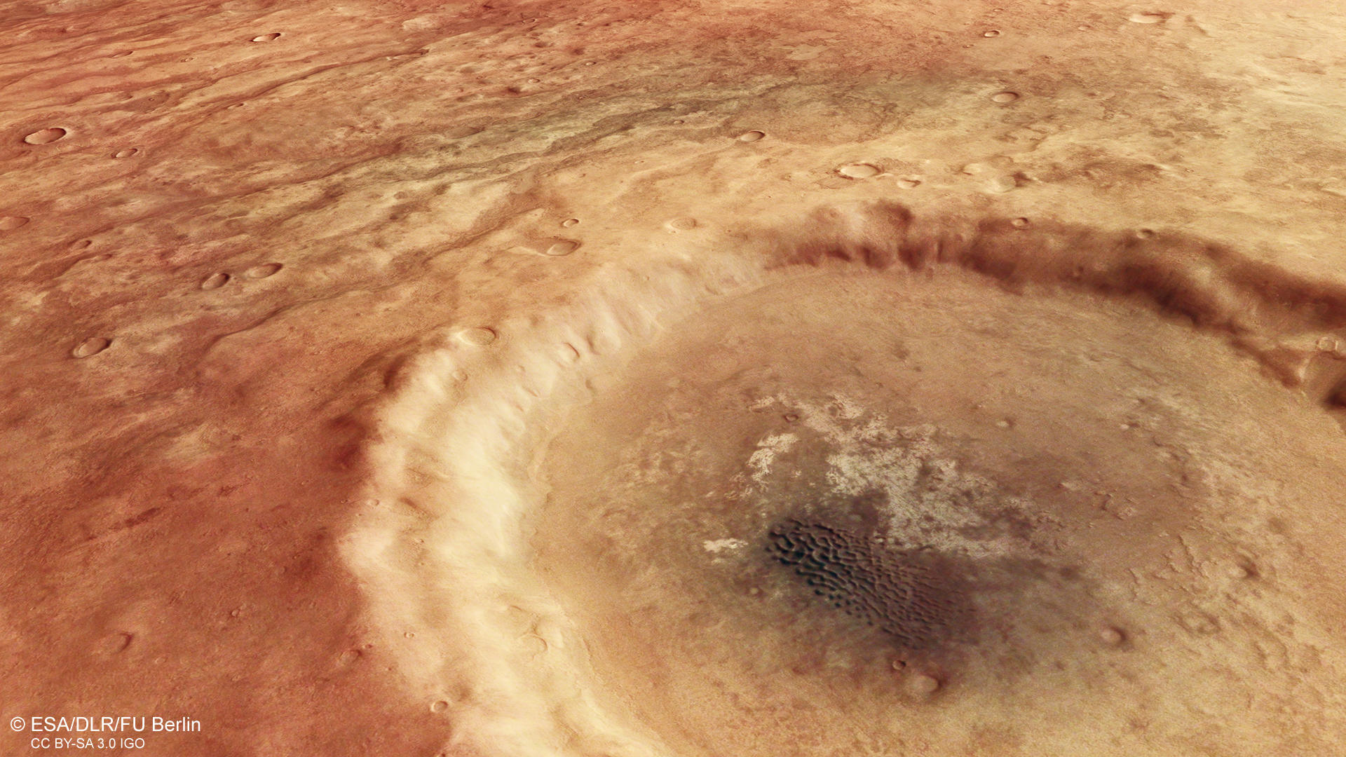
Aonia Terra is an upland region in the southern highlands of Mars and known for massive cratering like the 200 km large and famous Lowell crater (see overview map) just 130 km southwest of the crater shown in the center of the image. The 30 km wide unnamed impact crater is embedded in a surprisingly colorful landscape of large channel networks. These valleys are interpreted as an indication for precipitation of liquid water along with groundwater activity. The channels were active in the Late Noachian and Early Hesperian epochs of Mars. Interestingly, the valleys appear to be partly filled with a dark colored material and the relief seems to be inverted in some few points. This inversion of relief can occur when the materials filling the valley floor are, or become, more resistant to erosion than the adjacent surface. This may happen by channel bed sediment induration through geochemical cementation under the presence of water, or by armoring of the channel bed with erosion resistant, often coarse-grained sediments. Another possibility is a later infill of the valleys with lava in volcanic regions.
The surface around the impact crater likely consists of different materials. South of the crater (left side of the image), the surface displays a warm red color, changing towards a darker brown/grayish tone closer to the crater. In this region, many small buttes can be found. Then, the surface appears fairly smoothened, this becomes well visible at the crater rims and further to the north (right side of the image). Here the coloration of the surface changes towards a lighter tone, and the rims of the channels appear less defined. Finally, at the right side of the image, the surface looks much smoother. These many colors hint a surprising variability of the surface mineralogy in this region.
Inside the impact crater, a beautiful dark dune field can be spotted measuring just 5.4 x 2.7 km, resting on a light-toned, bright deposit. At closer inspection, many little buttes and knobs can also be found inside the crater, showing that the crater is filled with different materials that accumulated inside. Measurements from the THEMIS instrument on board of NASA’s Mars Odyssey spacecraft document a very high thermal inertia in these deposits confirming the wide difference in composition.
High Resolution Stereo Camera (HRSC)
» information to image origin and processing
The images were acquired by the HRSC (High Resolution Stereo Camera) on 25 April 2022 during Mars Express Orbit 23137. The ground resolution is approximately 14 meters per pixel and the images are centered at about 282° East and 48° South. The color image was created using data from the nadir channel, the field of view which is aligned perpendicular to the surface of Mars, and the color channels of the HRSC. The anaglyph image, which creates a three-dimensional impression of the landscape when viewed with red/blue or red/green glasses, was derived from the nadir channel and one stereo channel. The oblique perspective view was generated from the digital terrain model, the nadir and color channels of HRSC. The color-coded topographic view is based on a digital terrain model (DTM) of the region, from which the topography of the landscape can be derived. The reference body for the HRSC-DTM is a Mars equipotential surface (Areoid).
HRSC is a camera experiment that was developed and is operated by the German Aerospace Center (Deutsches Zentrum für Luft- und Raumfahrt; DLR).The systematic processing of the camera data took place at the DLR Institute for Planetary Research in Berlin-Adlershof. The working group of Planetary Science and Remote Sensing at Freie Universität Berlin used the data to create the image products shown here.
To download released raw images and DTMs of the region in GIS-ready formats, follow this link to the mapserver.
Images: ESA/DLR/FU Berlin, CC BY-SA 3.0 IGO
Copyright Notice:
Where expressly stated, images are licenced under the Creative Commons Attribution-ShareAlike 3.0 IGO (CC BY-SA 3.0 IGO) licence. The user is allowed to reproduce, distribute, adapt, translate and publicly perform it, without explicit permission, provided that the content is accompanied by an acknowledgement that the source is credited as 'ESA/DLR/FU Berlin', a direct link to the licence text is provided and that it is clearly indicated if changes were made to the original content. Adaptation / translation / derivatives must be distributed under the same licence terms as this publication.
The High Resolution Stereo Camera was developed at the German Aerospace Center (DLR) and built in collaboration with partners in industry (EADS Astrium, Lewicki Microelectronic GmbH and Jena-Optronik GmbH). The science team, which is headed by Principal Investigator (PI) Dr. Thomas Roatsch, consists of 52 co-investigators from 34 institutions and 11 countries. The camera is operated by the DLR Institute of Planetary Research in Berlin-Adlershof.