Department of Earth Sciences
Service Navigation
Who left the dark tracks on Mars?
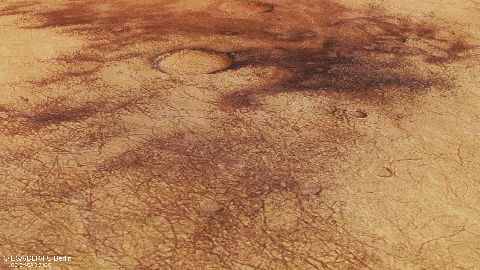
Images acquired at the beginning of 2019 using the High Resolution Stereo Camera (HRSC) on board the ESA Mars Express spacecraft show a region in the southern hemisphere of Mars that is characterized by an extensive dust cover and eolian activity, as evident from dark dunes and dust devil tracks.
» Read more about dust devil tracks in the main article and below the gallery
Dust Devils • Location and Scheme

context map
Image Credit: MOLA Science Team/FU Berlin

dust devil formation
Image Credit: modified after Ramon Peñas/The National
Dust Devils • Images

HRSC color image
Image Credit: ESA/DLR/FU Berlin

HRSC color-coded terrain model
Image Credit: ESA/DLR/FU Berlin

HRSC anaglyph
Image Credit: ESA/DLR/FU Berlin
Who left the dark tracks on Mars?
» Read more about dust devil tracks
The dark, narrow, thread-like stripes that can be seen in the images are the traces of small whirlwinds – known as dust devils – which are caused by atmospheric turbulence. Dust devils on Mars form in a similar way to their counterparts on Earth – as the Martian soil is warmed by sunlight during the day, the heated air rises, creating an updraught. Under certain conditions, this updraught then begins to rotate, causing a vertical vortex. Differences in atmospheric pressure create a suction effect, lifting any loose material from the surface. On Mars, this loose material is dust; on Earth it may also come in the form of sand or snow. When a dust devil moves across the Martian surface, it lifts a thin layer of light-coloured sand from the ground, exposing the darker underlying material. These narrow dark tracks mark the paths taken by dust devils.
The trails left by dust devils on the Martian surface can be up to several hundred metres wide and several kilometres long. They tend to form in the afternoon on warm spring and summer days, when the surface is illuminated by sunlight for a longer time, and thus heats up more. Nevertheless, dust devils have also been observed during the winter months. Dust devil tracks may run straight or follow curved or winding paths, as well as intersecting or overlapping with one another. Their lifespan is relatively short, as they tend to be covered over again by light-coloured sand that is whipped up by dust storms, so that they disappear within a matter of days or months.
Dust devil traces can be found almost everywhere on Mars. They are particularly well documented on the plains of Amazonis Planitia and Argyre Planitia, as well as on Hellas Planitia, the lowland plain in Hellas, the largest impact basin on Mars. However, they can also be seen in the Proctor and Russell impact craters near the area shown here, as well as in many other regions of Mars. Although first-hand sightings of dust devils are far more common on our planet, they leave few recorded traces. They are typically observed in summer in dry desert landscapes, such as in the southwestern United States, Africa, Australia and China.
Large temperature differences due to intense warming during the day mean that the dust devils on Mars can be much bigger than those on Earth. On Mars, they can reach a height of eight kilometres, effectively carrying dust into the Martian atmosphere. Estimates suggest that overall, dust devils on Mars can lift as much material as a global dust storm, thus contributing significantly to an increased amount of dust in the atmosphere.
High Resolution Stereo Camera (HRSC)
» Information to image origin and processing
The images were acquired by the HRSC (High Resolution Stereo Camera) on 3 January 2019 during Mars Express Orbit 18983. The ground resolution is approximately 13 meters per pixel and the images are centered at about 23° East and 53° South. The color image was created using data from the nadir channel, the field of view which is aligned perpendicular to the surface of Mars, and the color channels of the HRSC. The oblique perspective view was generated from the digital terrain model, the nadir and color channels of HRSC. The anaglyph, which provides a three-dimensional view of the landscape when viewed using red-green or red-blue glasses, was derived from data acquired by the nadir channel and the stereo channels. The color-coded topographic view is based on a digital terrain model (DTM) of the region, from which the topography of the landscape can be derived. The reference body for the HRSC-DTM is a Mars equipotential surface (Areoid).
The systematic processing of the camera data took place at the DLR Institute for Planetary Research in Berlin-Adlershof. The working group of Planetary Science and Remote Sensing at Freie Universität Berlin used the data to create the image products shown here.
Images: ESA/DLR/FU Berlin, CC BY-SA 3.0 IGO
Copyright Notice:
Where expressly stated, images are licenced under the Creative Commons Attribution-ShareAlike 3.0 IGO (CC BY-SA 3.0 IGO) licence. The user is allowed to reproduce, distribute, adapt, translate and publicly perform it, without explicit permission, provided that the content is accompanied by an acknowledgement that the source is credited as 'ESA/DLR/FU Berlin', a direct link to the licence text is provided and that it is clearly indicated if changes were made to the original content. Adaptation / translation / derivatives must be distributed under the same licence terms as this publication.
The High Resolution Stereo Camera was developed at the German Aerospace Center (DLR) and built in collaboration with partners in industry (EADS Astrium, Lewicki Microelectronic GmbH and Jena-Optronik GmbH). The science team, which is headed by Principal Investigator (PI) Prof. Dr. Ralf Jaumann, consists of 52 co-investigators from 34 institutions and 11 countries. The camera is operated by the DLR Institute of Planetary Research in Berlin-Adlershof.