Department of Earth Sciences
Service Navigation
Acheron Fossae – Exploring the Western Edge of the Graben System
Image data, taken by the High Resolution Stereo Camera (HRSC) on board ESA’s Mars Express mission show the western part of the giant graben system Acheron Fossae HRSC is a camera experiment that was developed and is operated by the German Aerospace Center (Deutsches Zentrum für Luft- und Raumfahrt; DLR).
» read more in the main article below...
Acheron Fossae West • Position & 3D view

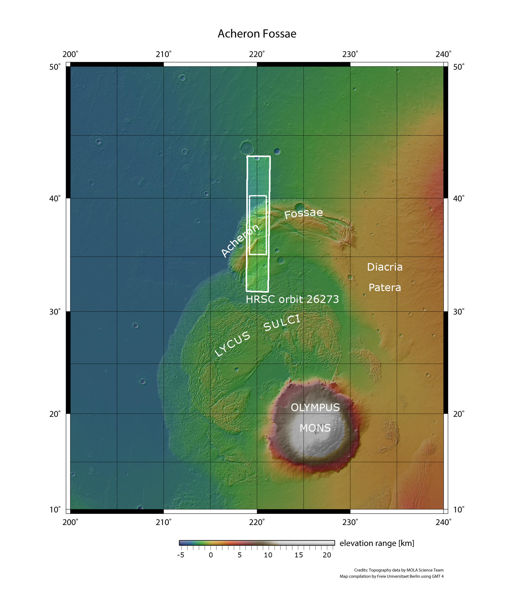
Acheron Fossae West - context map
Image Credit: MOLA Science Team/FU Berlin

Acheron Fossae West - 3D perspective 1
Image Credit: ESA/DLR/FU Berlin

Acheron Fossae West - 3D perspective 2
Image Credit: ESA/DLR/FU Berlin

Acheron Fossae West - 3D perspective 2
Image Credit: ESA/DLR/FU Berlin
Acheron Fossae West • HRSC images

Acheron Fossae West - HRSC color-coded terrain model
Image Credit: ESA/DLR/FU Berlin

Acheron Fossae West - HRSC color image
Image Credit: ESA/DLR/FU Berlin

Acheron Fossae West - HRSC annotated
Image Credit: ESA/DLR/FU Berlin

Acheron Fossae West - HRSC anaglyph
Image Credit: ESA/DLR/FU Berlin
Acheron Fossae West
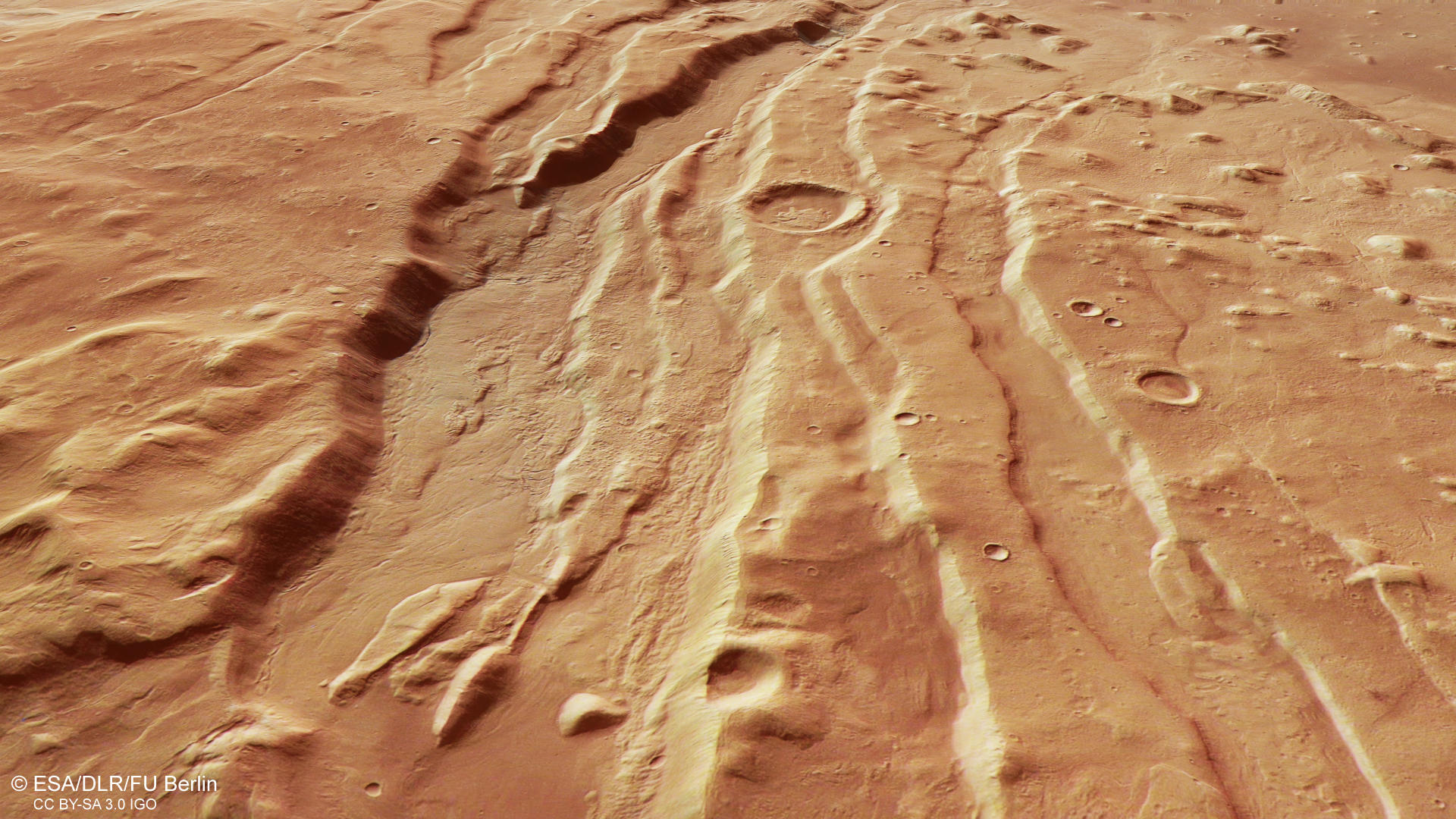
Following up on our April 2025 release, which explored the eastern part of Acheron Fossae, this HRSC image reveals the western edge of the region. Just a quick reminder: Acheron Fossae is located about 1200 kilometers north of Olympus Mons – the tallest shield volcano in our solar system. The entire ridge stretches roughly 800 kilometers and rises in the shape of an arc on the Martian surface – perfectly reflecting its name. On its northern and western side, the arc-shaped ridge transitions into the flat plains of Arcadia and Amazonis Planitia. To the south, the rift system scratches at the vast Aureole deposits – massive landslide accumulations formed by repeated collapses of Olympus Mons’ flanks (see context map).

horst-graben-AcheronFossae
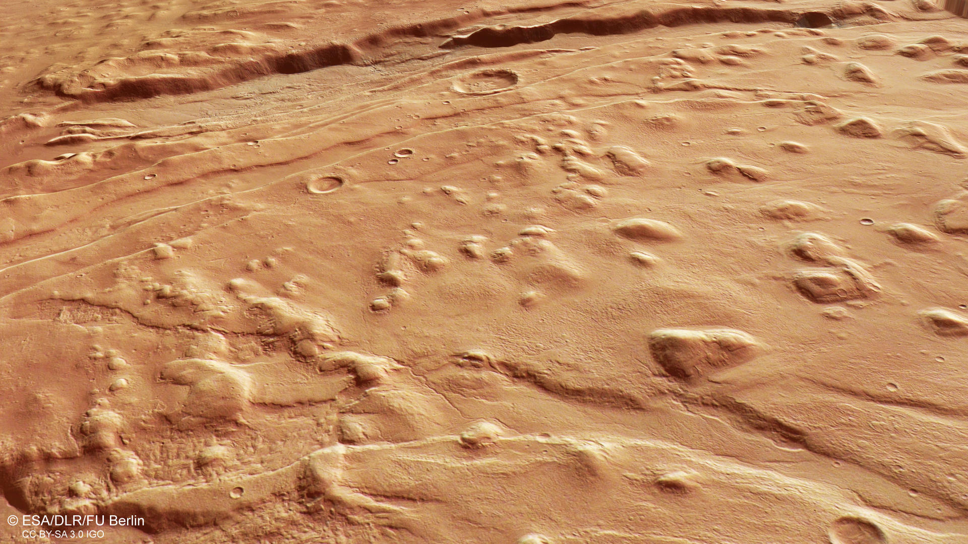
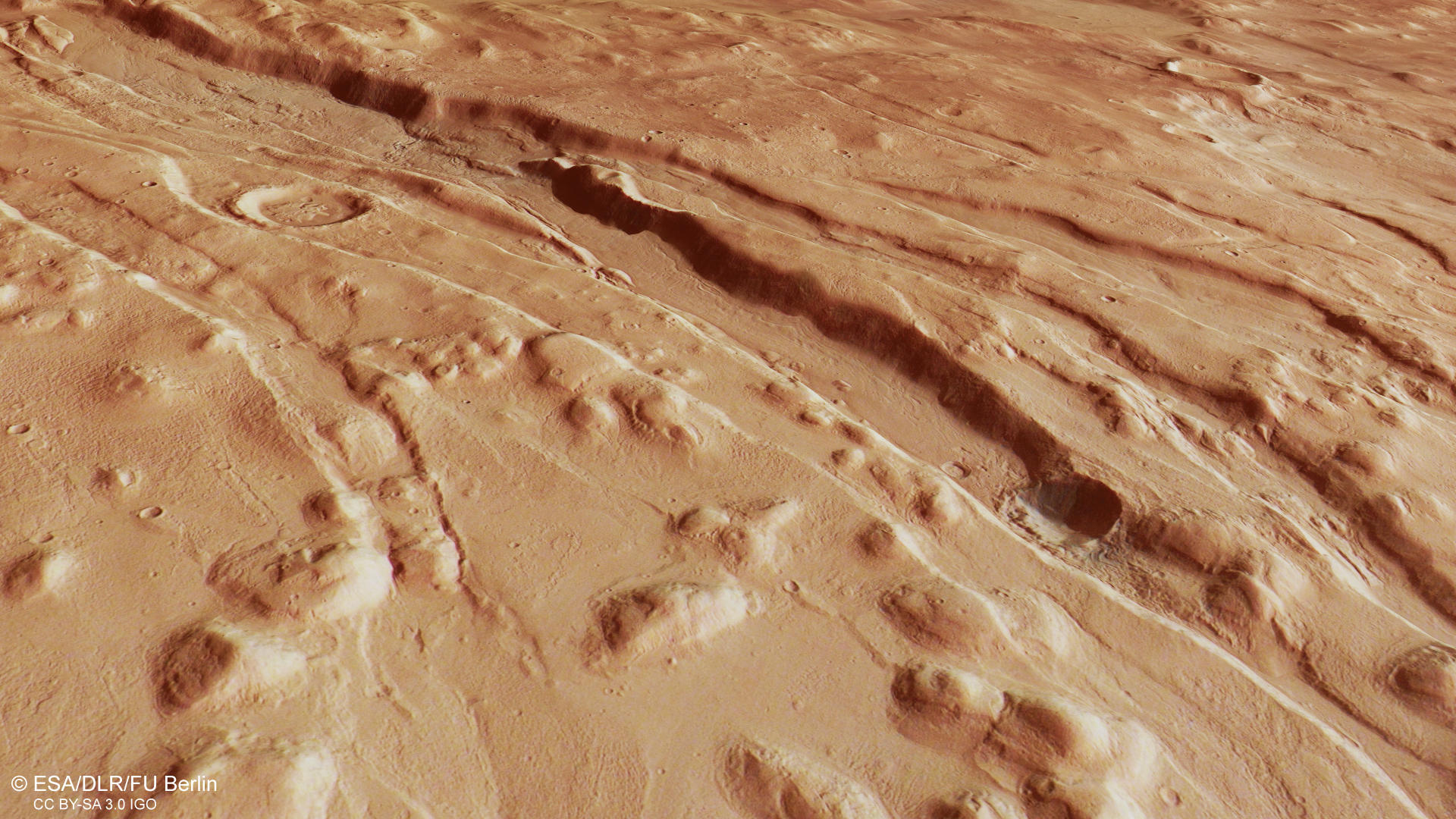
Acheron Fossae is marked by large, deep cracks on the surface known as ‘fossae’. These linear depressions are a textbook example of what’s called a ‘horst and graben’ landscape – a pattern of raised and lowered blocks of crust. The formation of such a structure is driven by the planet’s internal geological activity, where hot mantle material from deep inside rises toward the surface – a process known as mantle upwelling. This causes the ground to stretch and pull apart, leading blocks of crust to sink down (graben) relative to the neighboring higher blocks (horst). Since Mars was most geologically active during the Noachian period, around 3.7 to 3.9 billion years ago, Acheron Fossae likely formed in that period. Over time, many of these grabens have been filled with different types of material, especially deposits rich in ice.
In the HRSC images, multiple grabens of varying depths cut across the right (northern) side of the scene (see annotated image). A closer look reveals smooth material with a streamlined pattern on the floors of these grabens. These features are known as lineated valley fills and typically form through the slow, viscous flow of ice-rich debris (see annotated image). The deposits are believed to be mostly made up of ice covered by a layer of rock – similar to rock glaciers found here on Earth.
The flow-like feature is common in periglacial environments – not only on Earth but also on Mars. Their presence suggests that the region experienced alternating cold and warm periods, driven by repeated freeze–thaw cycles. These climatic fluctuations are caused by changes in Mars’ orbital parameters – especially the tilt of its rotation axis, known as obliquity. Unlike Earth’s relatively stable tilt of about 23.5°, thanks to our loyal companion the Moon, Mars’ axial tilt varies more dramatically and frequently due to gravitational influences from other planets. These obliquity cycles cause periodic shifts in Mars’ climate – and with them, changes in the distribution of ice. Simply put: during periods of high obliquity, ice spreads from the poles toward the mid-latitudes. When the tilt is lower, as it is today, the ice retreats back to the poles, leaving behind visible traces in the landscape.
Between the grabens and the adjacent lowlands, isolated remnants of what was once a continuous rock layer mark the landscape. These erosion-resistant remnants come in different shapes – some appear as rounded hills known as knobs, while others have flat tops and resemble small plateaus called mesas. Interestingly, many of them are partially surrounded by lineated valley fill material, which seems to have traveled all the way down to the lowlands. The knobs are most prominent on the right side (north) of the image. Toward the center and left-hand side, they gradually become fewer – and eventually disappear. All around the knobby terrain small, narrow meandering channels mark the surface (see annotated image). Meandering channels have a serpentine morphology formed by erosion and sedimentation of material.
The left side of the scene looks much smoother, which may point to a different geological origin. One possibility is that this smoother material may be linked to the massive landslides triggered by the collapse of Olympus Mons’ flanks forming its Aureole (see annotated image). If that is the case, the debris would have traveled a huge distance to reach the foot of Acheron Fossae.

Read more about the eastern part of Acheron Fossae in the press release from April 9, 2025 and explore all press releases with the interactive map.
→ Acheron Fossae – Glaciers and Volcanos in a giant Graben System
Find out more about the extensive Auerole of Olympus Mons in the press release from Aug 23 2023:
High Resolution Stereo Camera (HRSC)
The images were acquired by the HRSC (High Resolution Stereo Camera) on October 24, 2024 during Mars Express Orbits 26273. The ground resolution is approximately 16 meter per pixel and the image is centered at about 220° East and 37° North. The color image was created using data from the nadir channel, the field of view which is aligned perpendicular to the surface of Mars, and the color channels of the HRSC. The oblique perspective view was generated from the digital terrain model, the nadir and color channels of HRSC. The anaglyph image, which creates a three-dimensional impression of the landscape when viewed with red/blue or red/green glasses, was derived from the nadir channel and one stereo channel. The color-coded topographic view is based on a digital terrain model (DTM) of the region, from which the topography of the landscape can be derived.
HRSC is a camera experiment that was developed and is operated by the German Aerospace Center (Deutsches Zentrum für Luft- und Raumfahrt; DLR). The systematic processing of the camera data took place at the DLR Institute for Planetary Research in Berlin-Adlershof. The working group of Planetary Science and Remote Sensing at Freie Universität Berlin used the data to create the image products shown here.
To download released raw images and DTMs of the region in GIS-ready formats, follow this link to the mapserver
Images: ESA/DLR/FU Berlin, CC BY-SA 3.0 IGO
Copyright Notice:
Where expressly stated, images are licenced under the Creative Commons Attribution-ShareAlike 3.0 IGO (CC BY-SA 3.0 IGO) licence. The user is allowed to reproduce, distribute, adapt, translate and publicly perform it, without explicit permission, provided that the content is accompanied by an acknowledgement that the source is credited as 'ESA/DLR/FU Berlin', a direct link to the licence text is provided and that it is clearly indicated if changes were made to the original content. Adaptation / translation / derivatives must be distributed under the same licence terms as this publication.
The High Resolution Stereo Camera was developed at the German Aerospace Center (DLR) and built in collaboration with partners in industry (EADS Astrium, Lewicki Microelectronic GmbH and Jena-Optronik GmbH). The science team, which is headed by Principal Investigator (PI) Dr. Daniela Tirsch, consists of 50 co-investigators from 35 institutions and 11 countries. The camera is operated by the DLR Institute of Planetary Research in Berlin-Adlershof.