Department of Earth Sciences
Service Navigation
Deuteronilus Cavus – A Modified Impact Crater Shaped by Wind, Water and Ice
Image data, taken by the High Resolution Stereo Camera (HRSC) on board ESA’s Mars Express mission show the remnants of a large impact crater modified by glacial processes during Martian history. HRSC is a camera experiment that was developed and is operated by the German Aerospace Center (Deutsches Zentrum für Luft- und Raumfahrt; DLR).
» read more in the main article below...
Deuteronilus Cavus • Position & 3D view

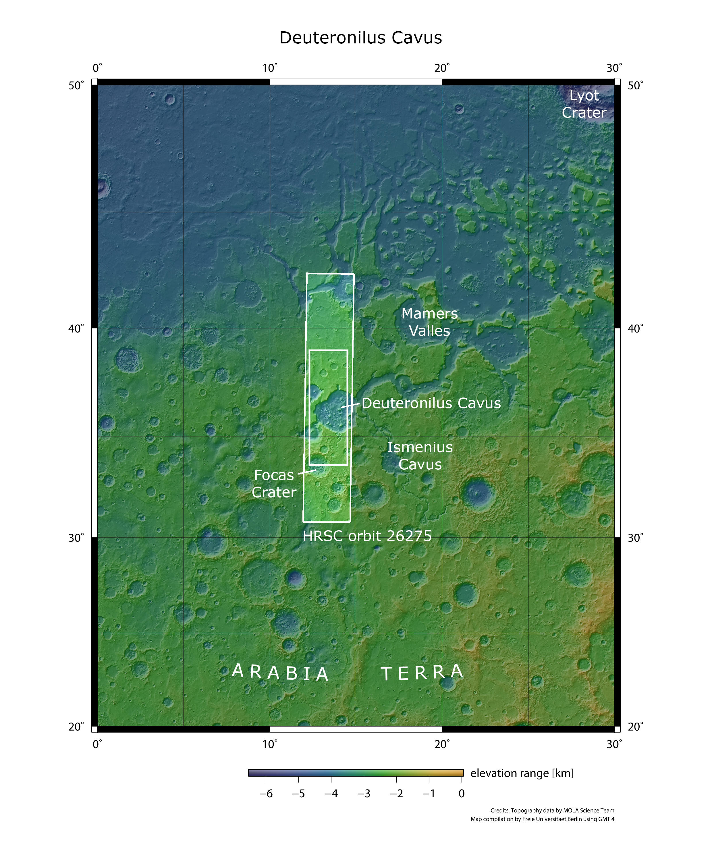
Deuteronilus Cavus - context map
Image Credit: MOLA Science Team/FU Berlin

Deuteronilus Cavus - 3D perspective 1
Image Credit: ESA/DLR/FU Berlin

Deuteronilus Cavus - 3D perspective 2
Image Credit: ESA/DLR/FU Berlin

Deuteronilus Cavus - 3D perspective 3
Image Credit: ESA/DLR/FU Berlin
Deuteronilus Cavus • HRSC images

Deuteronilus Cavus - HRSC color-coded terrain model
Image Credit: ESA/DLR/FU Berlin

Deuteronilus Cavus - HRSC color image
Image Credit: ESA/DLR/FU Berlin

Deuteronilus Cavus - HRSC annotated
Image Credit: ESA/DLR/FU Berlin

Deuteronilus Cavus - HRSC anaglyph
Image Credit: ESA/DLR/FU Berlin
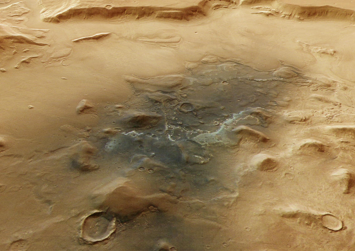
Deuteronilus Cavus is a roughly 120-kilometer-wide depression located in the Ismenius Lacus quadrangle of Mars, within the northern mid-latitudes of Arabia Terra. The name Deuteronilus is derived from Greek and means "second Nile," referencing the nearby Mamers Valles. Mamers Valles is a valley system that stretches over 1,000 kilometers, originating in the southern highlands and extending into the northern lowlands. The valley intersects Deuteronilus Cavus to the east. The Deuteronilus region is commonly referred to as fretted terrain — the transitional zone between the highlands and lowlands — characterized by knobs, mesas, branching channels, and depressions that often exhibit flow-like structures. Deuteronilus Cavus preserves a rich geological history, spanning from ancient Noachian terrain to Amazonian-aged surface deposits.
The nearly circular shape of the depression suggests an impact crater origin, likely formed during the Noachian period. Over time, glacial and fluvial activity significantly reshaped the original crater, enlarging it to nearly twice its initial size. The depression lies within the ancient, cratered highlands of Arabia Terra. Surrounding features include large craters such as Focas Crater (approximately 75 kilometers wide) to the southwest, as well as wrinkle ridges that overlie the ancient terrain. These ridges are surface expressions of lava flows that cooled and contracted, indicating a later period of volcanic activity.
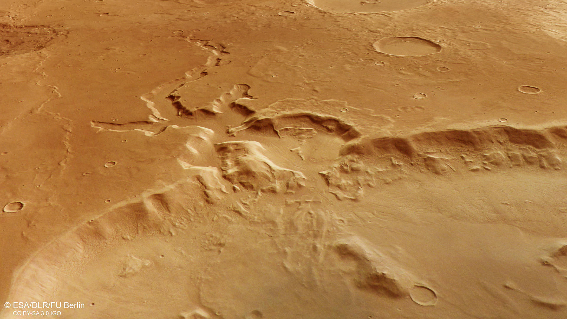
While the surrounding terrain dates back to the Noachian period, the depression itself displays several features indicative of more recent geological activity. The HRSC images reveal that the degraded crater rim is cut in some areas, likely due to mass-wasting resulting from groundwater sapping. Notably, in the southern part of the depression, branching channels, resembling to sapping structures are visible (see annotated image). These channels suggest that drainage ways could have been created by the outflow of subsurface fluids. Along nearly all sections of the crater wall, viscous flow patterns can be observed with a flow direction downward (see annotated image). These features are known as lobate debris aprons and are often interpreted as debris-covered glaciers, consisting of ice-rich material beneath a protective rock layer. These aprons are a typical feature in the mid-latitudes (see April PR - Acheron Fossae) and are believed to form during periods of high obliquity (increased axial tilt) in the Amazonian period, when climatic conditions allowed ice to accumulate.
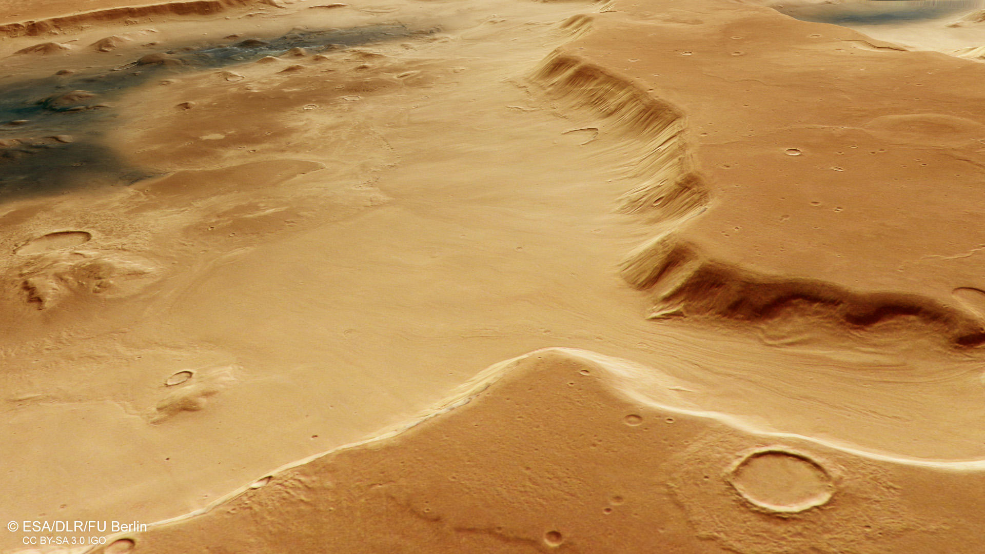
Inside the depression, the landscape shows a mix of knobs, mesas, and smoother plains. A closer view of one of the knobs near the crater wall shows that it is partially enclosed by lobate debris aprons. The knobs and mesas may be erosional remnants of a formerly continuous rock layer or, particularly toward the center of the depression the remnants of a former central peak structure. However, these “knobby remnants” are a common feature in “fretted” regions.
Toward the center of the depression, darker surface material is visible, likely consisting of aeolian deposits that often accumulate in depressions. The dark material could be of volcanic origin. Spectral analysis also detected the presence of phyllosilicates concentrated within these darker deposits. Phyllosilicates are clay minerals that typically form through aqueous alteration of volcanic ash in marine or lacustrine environments, suggesting that liquid water once played an important role in this region.

High Resolution Stereo Camera (HRSC)
The images were acquired by the HRSC (High Resolution Stereo Camera) on October 25, 2024 during Mars Express Orbits 26275. The ground resolution is approximately 18 meter per pixel and the image is centered at about 14° East and 36° North. The color image was created using data from the nadir channel, the field of view which is aligned perpendicular to the surface of Mars, and the color channels of the HRSC. The oblique perspective view was generated from the digital terrain model, the nadir and color channels of HRSC. The anaglyph image, which creates a three-dimensional impression of the landscape when viewed with red/blue or red/green glasses, was derived from the nadir channel and one stereo channel. The color-coded topographic view is based on a digital terrain model (DTM) of the region, from which the topography of the landscape can be derived.
HRSC is a camera experiment that was developed and is operated by the German Aerospace Center (Deutsches Zentrum für Luft- und Raumfahrt; DLR). The systematic processing of the camera data took place at the DLR Institute for Planetary Research in Berlin-Adlershof. The working group of Planetary Science and Remote Sensing at Freie Universität Berlin used the data to create the image products shown here.
To download released raw images and DTMs of the region in GIS-ready formats, follow this link to the mapserver
Images: ESA/DLR/FU Berlin, CC BY-SA 3.0 IGO
Copyright Notice:
Where expressly stated, images are licenced under the Creative Commons Attribution-ShareAlike 3.0 IGO (CC BY-SA 3.0 IGO) licence. The user is allowed to reproduce, distribute, adapt, translate and publicly perform it, without explicit permission, provided that the content is accompanied by an acknowledgement that the source is credited as 'ESA/DLR/FU Berlin', a direct link to the licence text is provided and that it is clearly indicated if changes were made to the original content. Adaptation / translation / derivatives must be distributed under the same licence terms as this publication.
The High Resolution Stereo Camera was developed at the German Aerospace Center (DLR) and built in collaboration with partners in industry (EADS Astrium, Lewicki Microelectronic GmbH and Jena-Optronik GmbH). The science team, which is headed by Principal Investigator (PI) Dr. Daniela Tirsch, consists of 50 co-investigators from 35 institutions and 11 countries. The camera is operated by the DLR Institute of Planetary Research in Berlin-Adlershof.