Department of Earth Sciences
Service Navigation
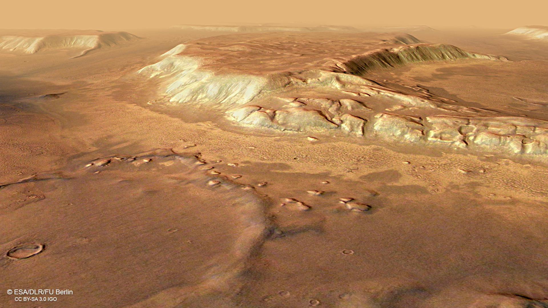
Glacial landforms in Deuteronilus Mensae
Image data by the High Resolution Stereo Camera (HRSC) on board ESA’s Mars Express mission show glacial features at the dichotomy boundary on Mars. HRSC is a camera experiment that was developed and is operated by the German Aerospace Center (Deutsches Zentrum für Luft- und Raumfahrt; DLR).
» Read more about Deuteronilus Mensae in the main article and below the gallery...
Deuteronilus Mensae • Location and Scheme

context map
Image Credit: MOLA Science Team/FU Berlin

Lobate Debris Aprons around Mesas
Image Credit: modified after van Gasselt 2007
Deuteronilus Mensae • Images

HRSC color image
Image Credit: ESA/DLR/FU Berlin

HRSC color-coded terrain model
Image Credit: ESA/DLR/FU Berlin

HRSC anaglyph
Image Credit: ESA/DLR/FU Berlin
Glacial landforms on Mars
» Read more about the icy landscape in Deuteronilus Mensae
Deuteronilus Mensae is situated at the transition from the rugged and cratered southern highlands to the smooth northern lowlands, referred to as the Martian hemispheric dichotomy. The landscape here at the dichotomy boundary was deeply eroded by fluvial, mass wasting and in particular ice related processes. Fretting and dissection of the ancient highland material resulted in the formation of isolated mesas with plateau-like surfaces, constituting eroded remnants of the plains that once extended further to the north.
During the past, the region experienced extensive glaciation and is therefore characterized by landforms that resulted from multiple glacial epochs. All of the low lying terrain is covered by smooth deposits, partly showing flow patterns that indicate slow downhill movement of the material. The viscous flow features surrounding the plateaus resemble rock glaciers and debris-covered glaciers found in cold-climate areas on Earth, and most likely consist of ice mixed with mass-wasted debris.
Data analysis of the Shallow Radar (SHARAD) instrument onboard Mars Reconnaissance Orbiter indicate that most of the glacier-like landforms in Deuteronilus Mensae contain a high amount of 80-90% of pure water ice. The widespread glacier-like features may represent the preserved remnants of a regional ice sheet, which once could have covered the plateaus and plains. Sublimation in the course of climate change could then have led to down wasting of the ice sheet, exposing and eroding the plateau scarps. Later, annual atmospheric ice and dust deposits form a thick mantling layer. The “ribbed texture” of the smooth plains in the northern part of the image can be explained with downhill creep, leading to fractured ridge and furrow patterns.
High Resolution Stereo Camera (HRSC)
» Information to image origin and processing
The images were acquired by the HRSC (High Resolution Stereo Camera) on 25 February 2018 during Mars Express Orbit 17913. The ground resolution is approximately 13 meters per pixel and the images are centered at about 25.5° East and 44° North. The color image was created using data from the nadir channel, the field of view which is aligned perpendicular to the surface of Mars, and the color channels of the HRSC. The oblique perspective view was generated from the digital terrain model, the nadir and color channels of HRSC. The anaglyph, which provides a three-dimensional view of the landscape when viewed using red-green or red-blue glasses, was derived from data acquired by the nadir channel and the stereo channels. The color-coded topographic view is based on a digital terrain model (DTM) of the region, from which the topography of the landscape can be derived. The reference body for the HRSC-DTM is a Mars equipotential surface (Areoid).
The systematic processing of the camera data took place at the DLR Institute for Planetary Research in Berlin-Adlershof. The working group of Planetary Science and Remote Sensing at Freie Universität Berlin used the data to create the image products shown here.
Images: ESA/DLR/FU Berlin, CC BY-SA 3.0 IGO
Copyright Notice:
Where expressly stated, images are licenced under the Creative Commons Attribution-ShareAlike 3.0 IGO (CC BY-SA 3.0 IGO) licence. The user is allowed to reproduce, distribute, adapt, translate and publicly perform it, without explicit permission, provided that the content is accompanied by an acknowledgement that the source is credited as 'ESA/DLR/FU Berlin', a direct link to the licence text is provided and that it is clearly indicated if changes were made to the original content. Adaptation / translation / derivatives must be distributed under the same licence terms as this publication.
The High Resolution Stereo Camera was developed at the German Aerospace Center (DLR) and built in collaboration with partners in industry (EADS Astrium, Lewicki Microelectronic GmbH and Jena-Optronik GmbH). The science team, which is headed by Principal Investigator (PI) Prof. Dr. Ralf Jaumann, consists of 52 co-investigators from 34 institutions and 11 countries. The camera is operated by the DLR Institute of Planetary Research in Berlin-Adlershof.