Department of Earth Sciences
Service Navigation
The Clays of Mawrth Revisited
Image data, taken by the High Resolution Stereo Camera (HRSC) on board ESA’s Mars Express mission show thick light-toned clay deposits in the Mawrth Vallis region. HRSC is a camera experiment that was developed and is operated by the German Aerospace Center (Deutsches Zentrum für Luft- und Raumfahrt; DLR).
» read more in the main article below...
Mawrth Vallis • Position & 3D view

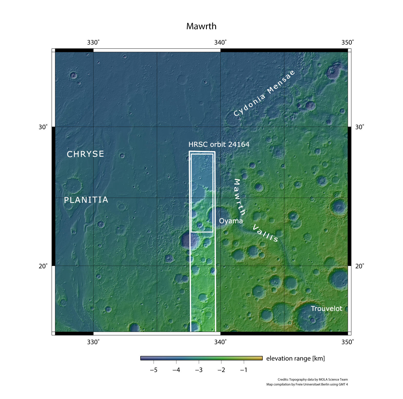
Mawrth Vallis - context map
Image Credit: MOLA Science Team/FU Berlin

Mawrth Vallis - 3D 1
Image Credit: ESA/DLR/FU Berlin

Mawrth Vallis - 3D 2
Image Credit: ESA/DLR/FU Berlin

Mawrth Vallis - 3D 3
Image Credit: ESA/DLR/FU Berlin
Mawrth Vallis • HRSC images

Mawrth Vallis - HRSC color-coded terrain model
Image Credit: ESA/DLR/FU Berlin

Mawrth Vallis - HRSC color image
Image Credit: ESA/DLR/FU Berlin

Mawrth Vallis - HRSC annotated
Image Credit: ESA/DLR/FU Berlin

Mawrth Vallis - HRSC anaglyph
Image Credit: ESA/DLR/FU Berlin
The Clays of Mawrth Revisited
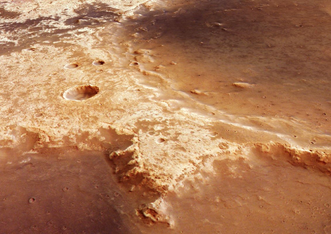
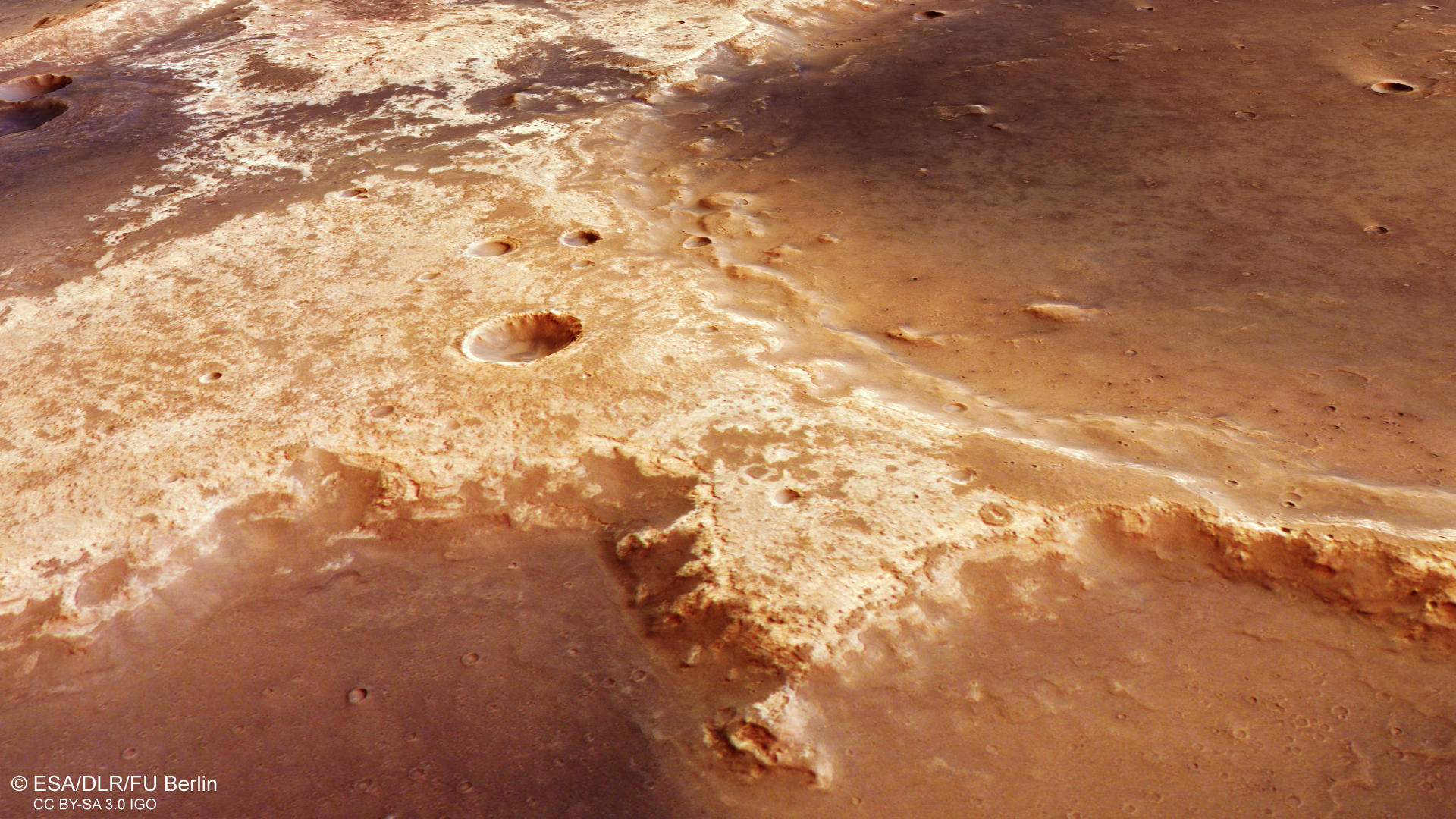
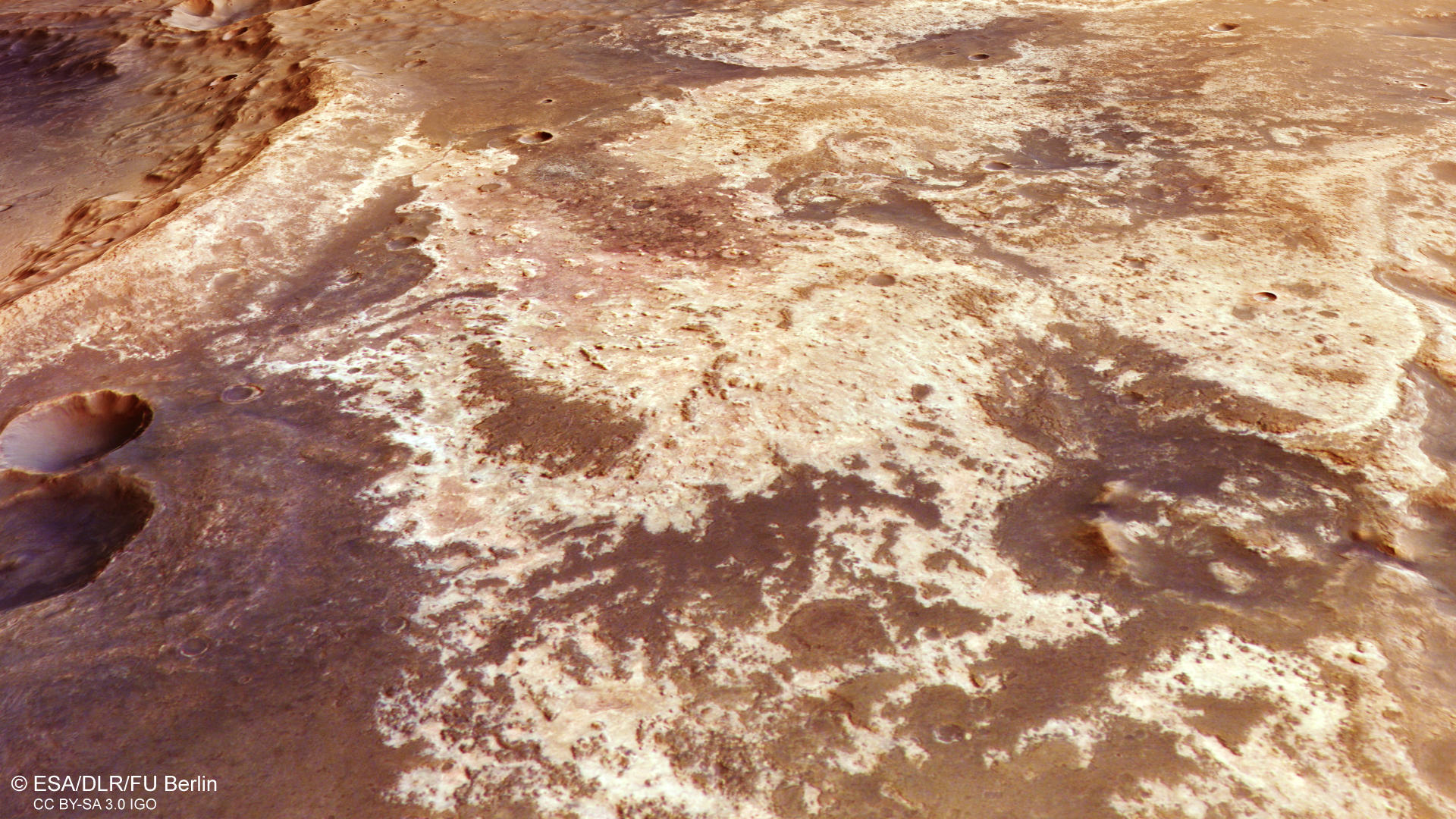
Once again Mars Express skimmed the Mawrth Vallis region, one of the most distinctive and fascinating regions of the red planet. The image was taken 130 km west of the Mawrth Vallis channel mouth. The multiple coverage makes it possible to observe changes on the surface of Mars. Often clouds or dust in the atmosphere cause variations in the image quality, especially in this region at the dichotomy boundary. Another important point is the acquisition of additional surface data points for the creation and improvement of terrain models and image mosaics. A large mosaic of the region was created in 2016 as well as an animation of the region.
The region is believed to harbor one of the most promising locations for the search for past and present life on the red planet. Light- and dark-toned deposits are found in and around the outflow channel Mawrth Vallis. The light-toned materials are the most widespread outcrops of phyllosilicates found on Mars and at places form a up to 200 m thick deposit. A dark cap rock unit overlies the clays, presumably of volcanic origin. Investigations with the spectrometer OMEGA (Observatoire pour la Minéralogie, l'Eau, les Glaces et l'Activité) also onboard Mars Express led to a better understanding of the clay minerals, that are iron-/magnesium-rich and aluminum-rich. In addition, sulfate-bearing deposits have been identified on the channel floor of Mawrth Vallis.Besides the mineralogy, the stratification of the light-toned rocks observable over a large area offers a particular opportunity to study depositional environments and also the climate history of Mars. The phyllosilicates on Mars could indicate surface alteration by aqueous activity and hint to a habitable environment in the Martian past. Liquid water once flowed through Mawrth Vallis, and existed on the surface presumably until 3.6 billion years ago. Maybe even traces of microbes were preserved in the rocks, protected from radiation and erosion by the overlying cap rock. Hence, astrobiologists have a great interest in this region of Mars.
Starting on the old and cratered “Highland” terrain, the 25 km wide impact crater on the left side (south) of the image shows a central pit and a part of its northern wall is collapsed. Central pit craters are impact craters, often observed on ice-rich planets and moons. The raised rims around the central pit is strongly suggestive of explosive excavation by steam explosion. Further to the right (north), large patches of the light-toned and clay-rich materials can be found. At closer look, they can also be found within crater walls, e.g. the smaller crater in the lower portion of the image. The dark, volcanic cap rock unit is also present in patches, often strongly eroded. Further to the north, the terrain steeply drops into the “Lowland” of Cryse Planitia. Two interconnected old and eroded impact crater walls can still stand out in the plain. The larger one measures roughly 75 km, the smaller one at the upper image border about 35 km in diameter. Further north, a field of numerous knobs and mesas can be spotted the larger mesas measure up to 3 km and they appear to be remnants of the former, now eroded “Highland” materials. Finally, in the top right corner of the image, a portion of a fluidized (or rampart) ejecta blanket can be found. These result from an impact into a surface that contains water or ice. According to the prevailing model, the water was released by the impact together with tons of rock and debris and the ejecta flowed like mud.
High Resolution Stereo Camera (HRSC)
The images were acquired by the HRSC (High Resolution Stereo Camera) on 18 February 2023 during Mars Express Orbits 24164. The ground resolution is approximately 18 meter per pixel and the image is centered at about 339° East and 25° North. The color image was created using data from the nadir channel, the field of view which is aligned perpendicular to the surface of Mars, and the color channels of the HRSC. The oblique perspective view was generated from the digital terrain model, the nadir and color channels of HRSC. The anaglyph image, which creates a three-dimensional impression of the landscape when viewed with red/blue or red/green glasses, was derived from the nadir channel and one stereo channel. The color-coded topographic view is based on a digital terrain model (DTM) of the region, from which the topography of the landscape can be derived. The reference body for the HRSC-DTM is a Mars equipotential surface (Areoid).
HRSC is a camera experiment that was developed and is operated by the German Aerospace Center (Deutsches Zentrum für Luft- und Raumfahrt; DLR). The systematic processing of the camera data took place at the DLR Institute for Planetary Research in Berlin-Adlershof. The working group of Planetary Science and Remote Sensing at Freie Universität Berlin used the data to create the image products shown here.
To download released raw images and DTMs of the region in GIS-ready formats, follow this link to the mapserver link:
Images: ESA/DLR/FU Berlin, CC BY-SA 3.0 IGO
Copyright Notice:
Where expressly stated, images are licenced under the Creative Commons Attribution-ShareAlike 3.0 IGO (CC BY-SA 3.0 IGO) licence. The user is allowed to reproduce, distribute, adapt, translate and publicly perform it, without explicit permission, provided that the content is accompanied by an acknowledgement that the source is credited as 'ESA/DLR/FU Berlin', a direct link to the licence text is provided and that it is clearly indicated if changes were made to the original content. Adaptation / translation / derivatives must be distributed under the same licence terms as this publication.
The High Resolution Stereo Camera was developed at the German Aerospace Center (DLR) and built in collaboration with partners in industry (EADS Astrium, Lewicki Microelectronic GmbH and Jena-Optronik GmbH). The science team, which is headed by Principal Investigator (PI) Dr. Thomas Roatsch, consists of 52 co-investigators from 34 institutions and 11 countries. The camera is operated by the DLR Institute of Planetary Research in Berlin-Adlershof.