Department of Earth Sciences
Service Navigation
Birth of Chaos - Craters and Collapses in Pyrrhae Regio
Image data by the High Resolution Stereo Camera (HRSC) on board ESA’s Mars Express mission show a fascinating landscape near the large canyon system of the Valles Marineris, the so-called Pyrrhae Regio. On a high plateau with many craters lies a geologically very "turbulent" area, which in technical terminology is called chaotic terrain. The High Resolution Stereo Camera (HRSC) is a camera experiment that was developed and is operated by the German Aerospace Center (Deutsches Zentrum für Luft- und Raumfahrt; DLR).
» read more in the main article and below the gallery about the Chaos in Pyrrhae Regio on Mars ...
Chaos in Pyrrhae Regio • Location and Scheme

Pyrrhae Regio Context map
Image Credit: MOLA Science Team/FU Berlin

Scheme for the creation of chaos areas
Image Credit: Freie Universität Berlin/FR Planetary Sciences and Remote Sensing
Chaos in Pyrrhae Regio • Images

Pyrrhae Regio HRSC color image
Image Credit: ESA/DLR/FU Berlin

Pyrrhae Regio HRSC color-coded terrain model
Image Credit: ESA/DLR/FU Berlin

Pyrrhae Regio HRSC anaglyph
Image Credit: ESA/DLR/FU Berlin
Chaos in Pyrrhae Regio
» read more about the Chaos in Pyrrhae Regio on Mars
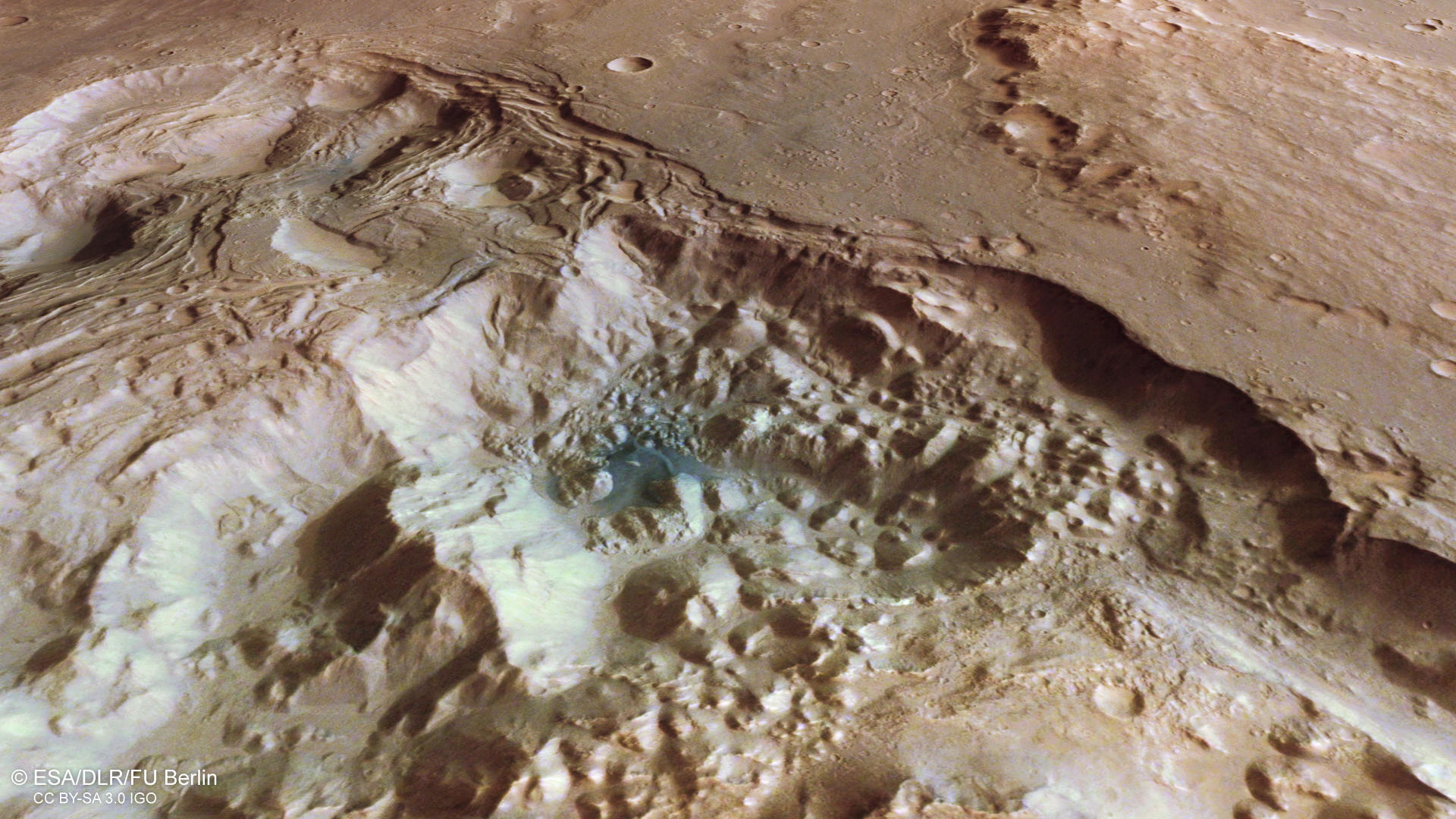
Located south of Eos Chasma, one of the eastern branches of the gigantic Valles Marineris canyon system, the Pyrrhae Regio stretches on the cratered, highland plateaus. The image presented here intriguingly displays the birth of a chaotic terrain on the northern (right in the color image) edge of the plan view.
Chaotic terrains are formed by collapse of the surface overlying (see also the scheme of origin) an ice and sediment containing reservoir. The ice melts for example triggered by lava flows, by volcanic intrusions at greater depth or by impacts. The water drains out of the sediments, often in a catastrophic and relatively quick and short-lived flood event. The small chaos shown here also possesses flood channels outside this observation in northwestern direction, visible on the context map. Research of the collapse structures in Eos Chasma and of Pyrrhae Regio shows, that these flood channels, named the Osuga Valles, hosted at least two flood events in opposite directions. First, the water drained from the Pyrrhae Regio towards Eos Chasma and later in the opposite direction. After the drainage, broken blocks remain in the cavity that hosted the ice. Presumably, groundwater upwelling also occurred during the collapse in addition to the meltwater release. The intruding groundwater then leads to slumps and breakoff at the rims and in consequence to an enlargement of the chasm. This chipping is very well visible at the rims of this small chaotic terrain. The height difference within this image is more than 4 km! The amount of material transported out of the chasm is enormous.
On the southern part (left side in the color image), sit 2 large and one smaller crater, the latter about 20 km in diameter, on a relatively undisturbed looking surface. The largest crater shows some fractures at its floor that could result from quick cooling of extruded lava after the impact. In the region between the impact craters and the chasm, two 2 km broad valleys can be spotted. These valleys, especially the upper one, show similarities to sapping valleys that are created by groundwater seepage. They may represent a further stage in the expansion of the chaotic terrain.
The region was named after Pyrrha, the daughter of Pandora and wife of Deukalion. In Greek mythology Deukalion has the same role as Noah. He was asked by his father Prometheus to build an ark to save himself and his wife from the great flood that Zeus had summoned to destroy mankind. Pyrrha and Deukalion were the only ones who survived the catastrophe and created mankind anew by throwing stones over their shoulders, from which humans were then created.
High Resolution Stereo Camera (HRSC)
» information to image origin and processing
The images were acquired by the HRSC (High Resolution Stereo Camera) on 3 August 2020 during Mars Express Orbit 20972. The ground resolution is approximately 16 meters per pixel and the images are centered at about 322° East and 16° South. The color image was created using data from the nadir channel, the field of view which is aligned perpendicular to the surface of Mars, and the color channels of the HRSC. The oblique perspective view was generated from the digital terrain model, the nadir and color channels of HRSC. The anaglyph, which provides a three-dimensional view of the landscape when viewed using red-green or red-blue glasses, was derived from data acquired by the nadir channel and the stereo channels. The color-coded topographic view is based on a digital terrain model (DTM) of the region, from which the topography of the landscape can be derived. The reference body for the HRSC-DTM is a Mars equipotential surface (Areoid).
HRSC is a camera experiment that was developed and is operated by the German Aerospace Center (Deutsches Zentrum für Luft- und Raumfahrt; DLR).The systematic processing of the camera data took place at the DLR Institute for Planetary Research in Berlin-Adlershof. The working group of Planetary Science and Remote Sensing at Freie Universität Berlin used the data to create the image products shown here.
To download released raw images and DTMs of the region in GIS-ready formats, follow this link to the mapserver.
Images: ESA/DLR/FU Berlin, CC BY-SA 3.0 IGO
Copyright Notice:
Where expressly stated, images are licenced under the Creative Commons Attribution-ShareAlike 3.0 IGO (CC BY-SA 3.0 IGO) licence. The user is allowed to reproduce, distribute, adapt, translate and publicly perform it, without explicit permission, provided that the content is accompanied by an acknowledgement that the source is credited as 'ESA/DLR/FU Berlin', a direct link to the licence text is provided and that it is clearly indicated if changes were made to the original content. Adaptation / translation / derivatives must be distributed under the same licence terms as this publication.
The High Resolution Stereo Camera was developed at the German Aerospace Center (DLR) and built in collaboration with partners in industry (EADS Astrium, Lewicki Microelectronic GmbH and Jena-Optronik GmbH). The science team, which is headed by Principal Investigator (PI) Prof. Dr. Ralf Jaumann, consists of 52 co-investigators from 34 institutions and 11 countries. The camera is operated by the DLR Institute of Planetary Research in Berlin-Adlershof.