Scenario 1
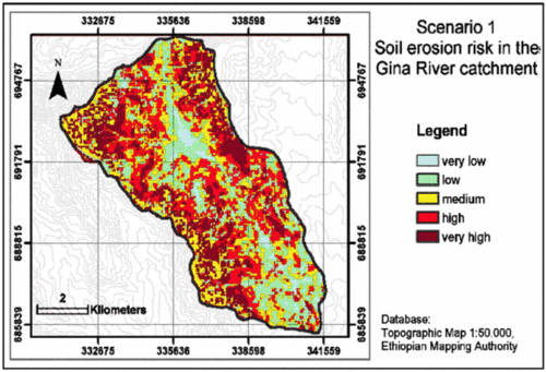
Scenario 1 - Semi-quantitative estimation of soil erosion risk in the Gina River catchment in the year 2020
Image Credit: Adapted from Beck et al. 2004
In scenario 1 it is assumed that the increase in settlement density coinciding with a doubling in population takes place by a linear increase of tukuls. Corresponding to the high density of widely scattered tukuls a dense network of tracks and roads will be developed allover the drainage basin.
Due to the doubled population an increased food supply is required. Thus, land use will be intensified and land that is today used as pastureland or woodland and forest will be used for tillage. Afforestation measures will not be intended as land in the Gina River catchment will be rare.
Also other soil conservation measures such as walls and terraces will not be implemented. Soil erosion risk for the Gina River catchment is assessed by implementing scenario 1 into the modelling equation. In a nutshell, the map shows that soil erosion risk will be distinctly increased allover the drainage basin area comparing to the present situation (see figure) (Beck et al. 2004).
Go ahead with Scenario 2.

