Land use
Agriculture
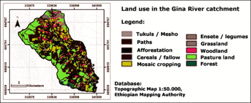
Lan use in the Gina River catchment is predominantly determined by various forms of agriculture (see figure).
Pastureland
Next to agriculture, the Gina River catchment is used intensively for pasture. Pasture land covers 32.5 % of the Gina River catchment.
Settlement
The density of houses (called tukuls in Ethiopia) amounts to 24 tukuls per km2 on average. However, tukuls are not equally distributed. Many tukuls are located around agricultural land. There is also a high density of paths in the Gina River catchment. Most of them run through areas used for agricultural purposes.
Woodland, Grassland and Forests
10 % of the basin is covered by woodland. This occurs mostly along the tributaries of the Gina River. Forests remain only at two location and grassland only at one site in the north of the Gina River catchment.
Which soil conservation measures are practiced is shown if you click on this hyperlink.

