Scenario 2
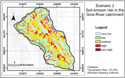
Scenario 2 - Semi-quantitative estimation of soil erosion risk in the Gina River catchment in the year 2020
Image Credit: Adapted from Beck et al. 2004, 70
In scenario 2 the doubled population will not live in widely scattered tukuls as assumed in scenario 1. Instead, they get concentrated in central towns (the already existing Mesho and four additional ones). No numerous footpaths will be scattered allover the Gina River catchment but bigger roads will connect the towns and the agricultural used areas.
Additionally, regional planning tools will be implemented to guarantee a susatainable management of natural resources:
- reforestation of the high erosion risk areas (like Steep slopes and Deep valleys) as an important soil and water conservation measure will be implemented;
- woody perennials will be combined with pasture (agroforestry) to avoid soil erosion on the Mountain tops;
- solar collectors in the settlements will reduce clearing of the forests;
- natural grassland will protect the Gina river from bank erosion and give space to flood events;
- terraces will constructed widely in agriculturally used areas.
The result of scenario 2 is implemented into the semi-quantitative modelling equation to assess soil erosion risk in the year 2020 under these circumstances. The resulting map shows a very low soil erosion risk in the Gina River catchment in comparison with the estimated soil erosion risk in scenario 1 and for today (see figure) (Beck et al. 2004).
This positive estimation compared with Scenario 1 highlights the importance of watershed planning and the application of regional planning tools to avoid hazard soil erosion processes to secure the living conditions of the population. These can be selected and implemented only on the base of sound data of the respective watershed. Thus, this scenario emphasises to the same time the huge importance of environmental analyses. An important contribution to this can be provided by traditional knowledge of the population which is topic of the next web pages.

