Department of Earth Sciences
Service Navigation
Coloe Fossae – What a Martian Ice Age Left Behind
Image data, taken by the High Resolution Stereo Camera(HRSC) on board ESA’s Mars Express mission show a complex region that separates the highlands from the lowlands, featuring the Coloe Fossae graben system, ice-related landforms, and more. HRSC is a camera experiment that was developed and is operated by the German Aerospace Center (Deutsches Zentrum für Luft- und Raumfahrt; DLR).
» read more in the main article below...
Coloe Fossae • Position & 3D view

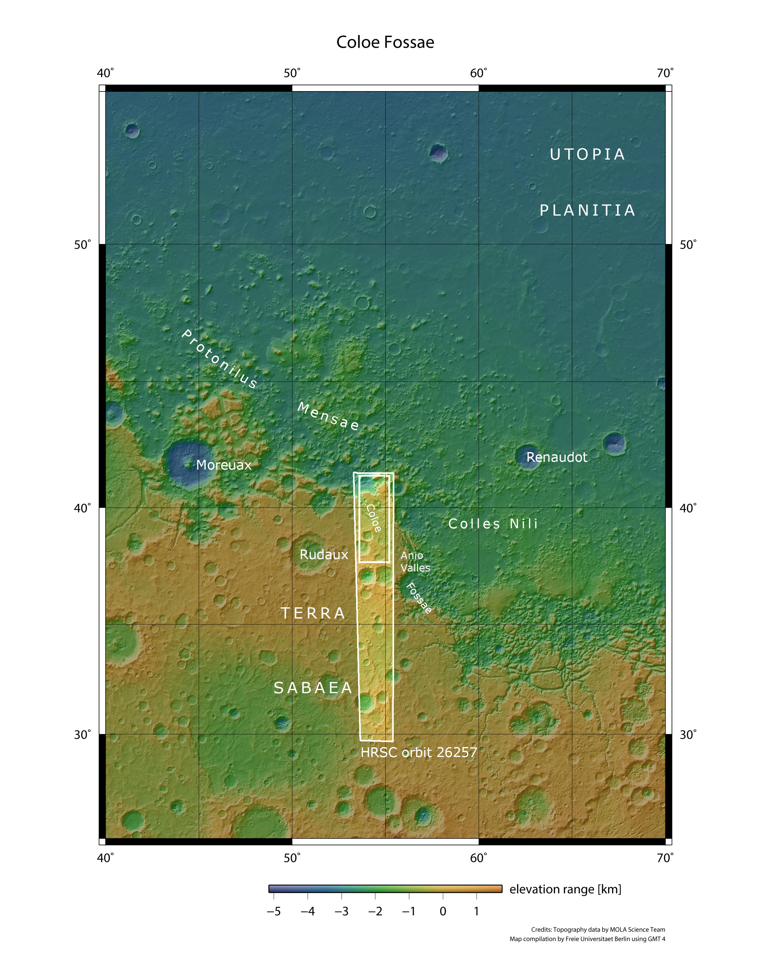
Coloe Fossae - context map
Image Credit: MOLA Science Team/FU Berlin

Coloe Fossae - 3D perspective 1
Image Credit: ESA/DLR/FU Berlin

Coloe Fossae - 3D perspective 2
Image Credit: ESA/DLR/FU Berlin

Coloe Fossae - 3D perspective 3
Image Credit: ESA/DLR/FU Berlin
Coloe Fossae • HRSC images

Coloe Fossae - HRSC color-coded terrain model
Image Credit: ESA/DLR/FU Berlin

Coloe Fossae - HRSC color image
Image Credit: ESA/DLR/FU Berlin

Coloe Fossae - HRSC annotated
Image Credit: ESA/DLR/FU Berlin

Coloe Fossae - HRSC anaglyph
Image Credit: ESA/DLR/FU Berlin
Coloe Fossae
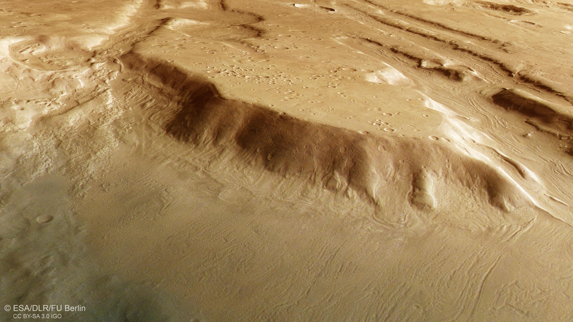
The region shown in the new HRSC image is located in Mars' northern hemisphere, along the planetary dichotomy boundary that separates the ancient southern highlands of Terra Sabaea from the northern lowlands of Utopia Planitia (see context map). This global boundary is generally characterized by a steep escarpment (or “cliff”), with an elevation difference of around two kilometers between the highlands and lowlands. In some areas, the boundary appears very sharp, while in others – such as the Coloe Fossae region – the transition between “high” and “low” is broad and complex. This transitional zone is known as Protonilus Mensae (see context map). It is marked by knobby terrain that rises from the lower plains and stretches for several hundred kilometers before reaching the flat northern lowlands. The region of Protonilus Mensae is also referred to as “fretted terrain” – a term that describes its eroded, knobby landscape.
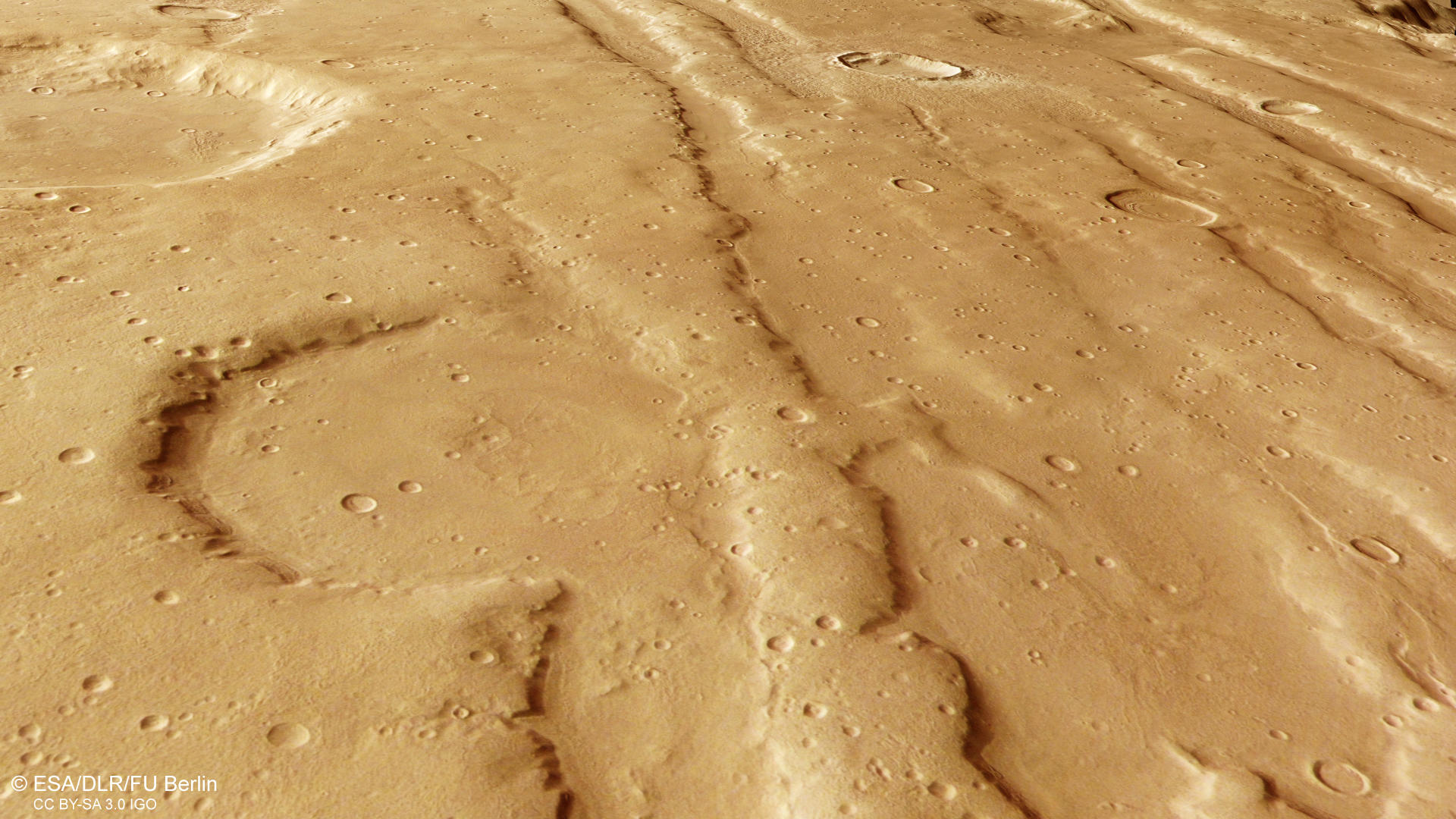
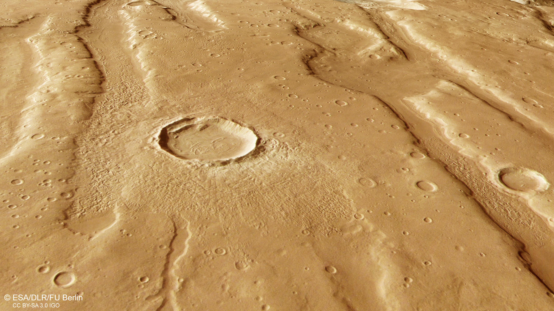
The HRSC image highlights linear, deep depressions on the surface known as Coloe Fossae – a well-defined graben system shaped by the planets internal forces. These grabens extend from north (right side of the image) to south (left side) and are separated by raised blocks of crust known as horsts, forming what geologists call a typical horst and graben structure (see annotated image). The surrounding terrain features several large impact craters, as well as smaller ones. Clusters of small craters, known as secondary crater fields, are also visible (see annotated image). These irregularly shaped secondary craters are formed when material is ejected during a larger impact event and then falls back to the surface. Secondary craters often appear as crater chains or, as seen in this image, as clusters located near the primary impact crater. On planetary bodies other than Earth, impact cratering is a key surface-modifying process. By analyzing the size and frequency of craters, scientists can estimate the relative ages of surfaces. Fewer craters generally indicate a younger surface that has been modified or resurfaced more recently. The significantly fewer impact craters on the graben floors suggest that these deposits may be relatively young compared to the heavily cratered surrounding terrain.
The floors of the depressions not only show fewer impact craters, but a closer look also reveals intriguing materials and surface features that provide valuable insights into Martian history – particularly its climatic evolution. In many locations, a specific streamlined pattern is visible, characteristic of what is known as lineated valley fill (see annotated image). The same pattern was recently observed in the August Press Release on Acheron Fossae West , a region located at similar latitudes on the opposite side of the planet. Lineated valley fill typically forms through the viscous flow of ice-rich debris and is interpreted as a glacial feature, resembling terrestrial rock glaciers – glaciers covered by a layer of debris or rock. These deposits are believed to consist of more than 80% ice, buried beneath a thick cover of rocky material. When such glacial features fill a valley, they are referred to as lineated valley fill. However, when similar features occur inside impact craters, they are known as concentric crater fill. In the HRSC image, this is not the most prominent feature, but upon a closer look, concentric crater fill can be observed in a few craters (see annotated image). But how did these glacial features accumulate so far from the Martian poles?
The presence of glacial features in the mid-latitudes of Mars suggests that the currently dry, red planet experienced alternating cold and warm periods, driven by repeated freeze–thaw cycles throughout its evolution. These climatic fluctuations are caused by changes in Mars’ orbital parameters – especially the tilt of its rotation axis, known as obliquity. Unlike Earth’s relatively stable tilt of about 23.5°, thanks to our loyal companion the Moon, Mars’ axial tilt varies more dramatically and frequently due to gravitational influences from other planets. These obliquity cycles cause periodic shifts in Mars’ climate – and with them, changes in the distribution of ice. Simply put: during periods of high obliquity, ice spreads from the poles toward the mid-latitudes. When the tilt is lower, as it is today, the ice retreats back to the poles, leaving behind visible traces in the landscape. The consistent presence of such features along the dichotomy at similar latitudes may point to global climatic drivers rather than localized environmental changes.
High Resolution Stereo Camera (HRSC)
The images were acquired by the HRSC (High Resolution Stereo Camera) on October 19, 2024 during Mars Express Orbits 26257. The ground resolution is approximately 16 meter per pixel and the image is centered at about 39° North and 54° East. The color image was created using data from the nadir channel, the field of view which is aligned perpendicular to the surface of Mars, and the color channels of the HRSC. The oblique perspective view was generated from the digital terrain model, the nadir and color channels of HRSC. The anaglyph image, which creates a three-dimensional impression of the landscape when viewed with red/blue or red/green glasses, was derived from the nadir channel and one stereo channel. The color-coded topographic view is based on a digital terrain model (DTM) of the region, from which the topography of the landscape can be derived.
HRSC is a camera experiment that was developed and is operated by the German Aerospace Center (Deutsches Zentrum für Luft- und Raumfahrt; DLR). The systematic processing of the camera data took place at the DLR Institute for Space Research in Berlin-Adlershof. The working group of Planetary Science and Remote Sensing at Freie Universität Berlin used the data to create the image products shown here.
To download released raw images and DTMs of the region in GIS-ready formats, follow this link to the mapserver
Images: ESA/DLR/FU Berlin, CC BY-SA 3.0 IGO
Copyright Notice:
Where expressly stated, images are licenced under the Creative Commons Attribution-ShareAlike 3.0 IGO (CC BY-SA 3.0 IGO) licence. The user is allowed to reproduce, distribute, adapt, translate and publicly perform it, without explicit permission, provided that the content is accompanied by an acknowledgement that the source is credited as 'ESA/DLR/FU Berlin', a direct link to the licence text is provided and that it is clearly indicated if changes were made to the original content. Adaptation / translation / derivatives must be distributed under the same licence terms as this publication.
The High Resolution Stereo Camera was developed at the German Aerospace Center (DLR) and built in collaboration with partners in industry (EADS Astrium, Lewicki Microelectronic GmbH and Jena-Optronik GmbH). The science team, which is headed by Principal Investigator (PI) Dr. Daniela Tirsch, consists of 50 co-investigators from 35 institutions and 11 countries. The camera is operated by the DLR Institute of Space Research in Berlin-Adlershof.