Department of Earth Sciences
Service Navigation
Angustus Labyrinthus - Ice Spiders in Inca City
Image data, taken by the High Resolution Stereo Camera (HRSC) on board ESA’s Mars Express mission show the enigmatic Angustus Labyrinthus in the south polar region of Mars. HRSC is a camera experiment that was developed and is operated by the German Aerospace Center (Deutsches Zentrum für Luft- und Raumfahrt; DLR).
» read more in the main article below...
Angustus Labyrinthus • Position & 3D view

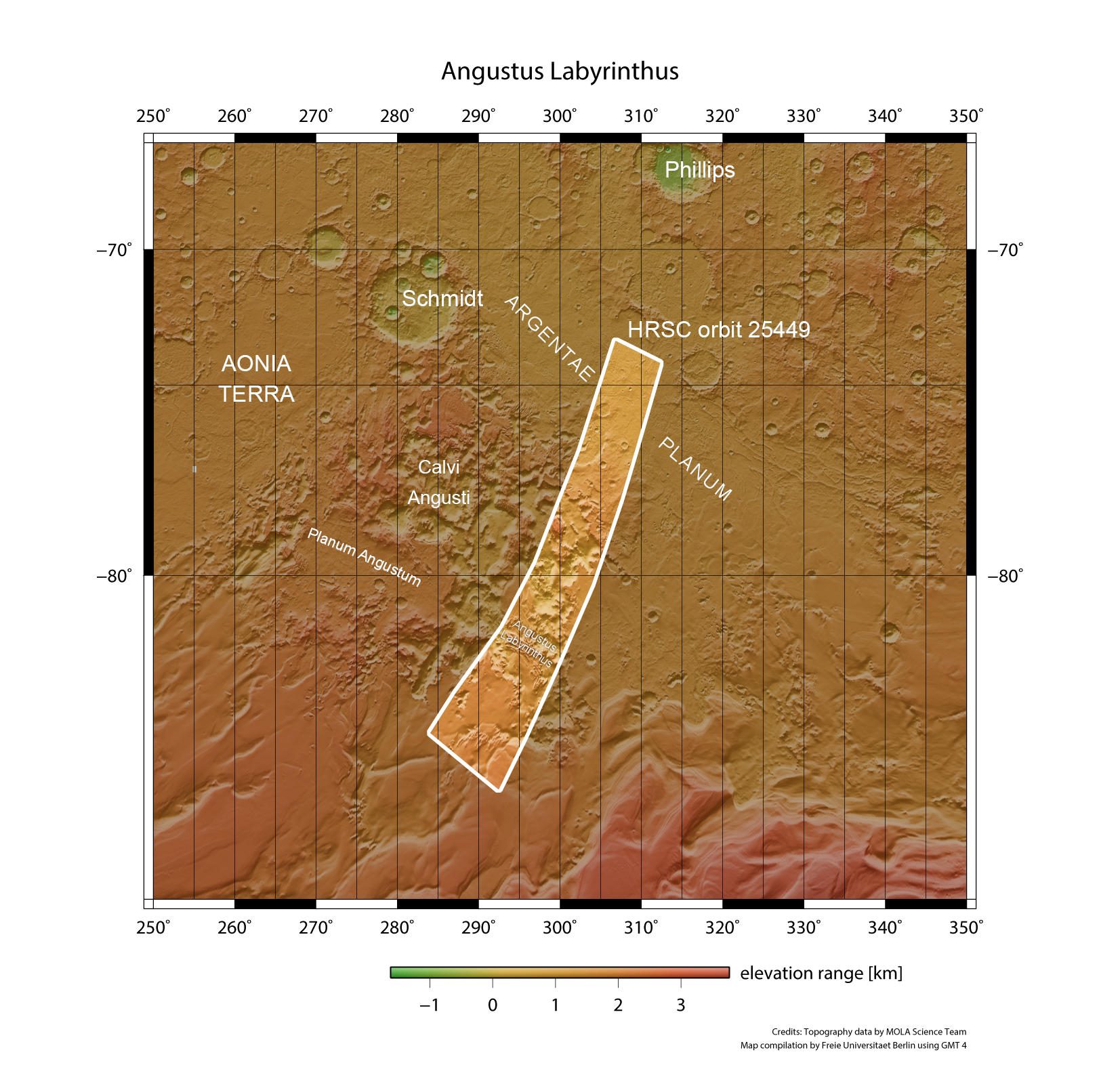
Angustus Labyrinthus - context map
Image Credit: MOLA Science Team/FU Berlin

Angustus Labyrinthus -3D 1
Image Credit: ESA/DLR/FU Berlin

Angustus Labyrinthus -3D 2
Image Credit: ESA/DLR/FU Berlin
Angustus Labyrinthus • HRSC images

Angustus Labyrinthus - HRSC color-coded terrain model
Image Credit: ESA/DLR/FU Berlin

Angustus Labyrinthus - HRSC color image
Image Credit: ESA/DLR/FU Berlin

Angustus Labyrinthus - HRSC anaglyph
Image Credit: ESA/DLR/FU Berlin

Angustus Labyrinthus - HRSC annotated
Image Credit: ESA/DLR/FU Berlin
Angustus Labyrinthus
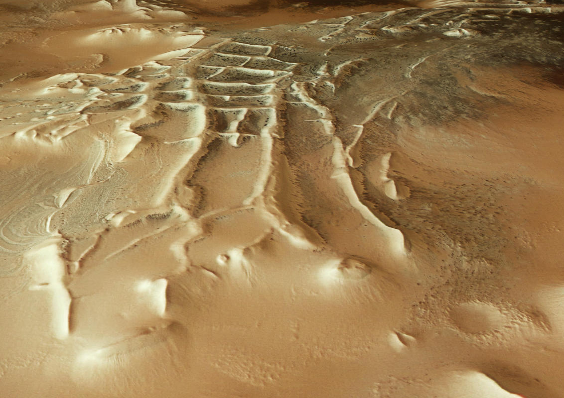
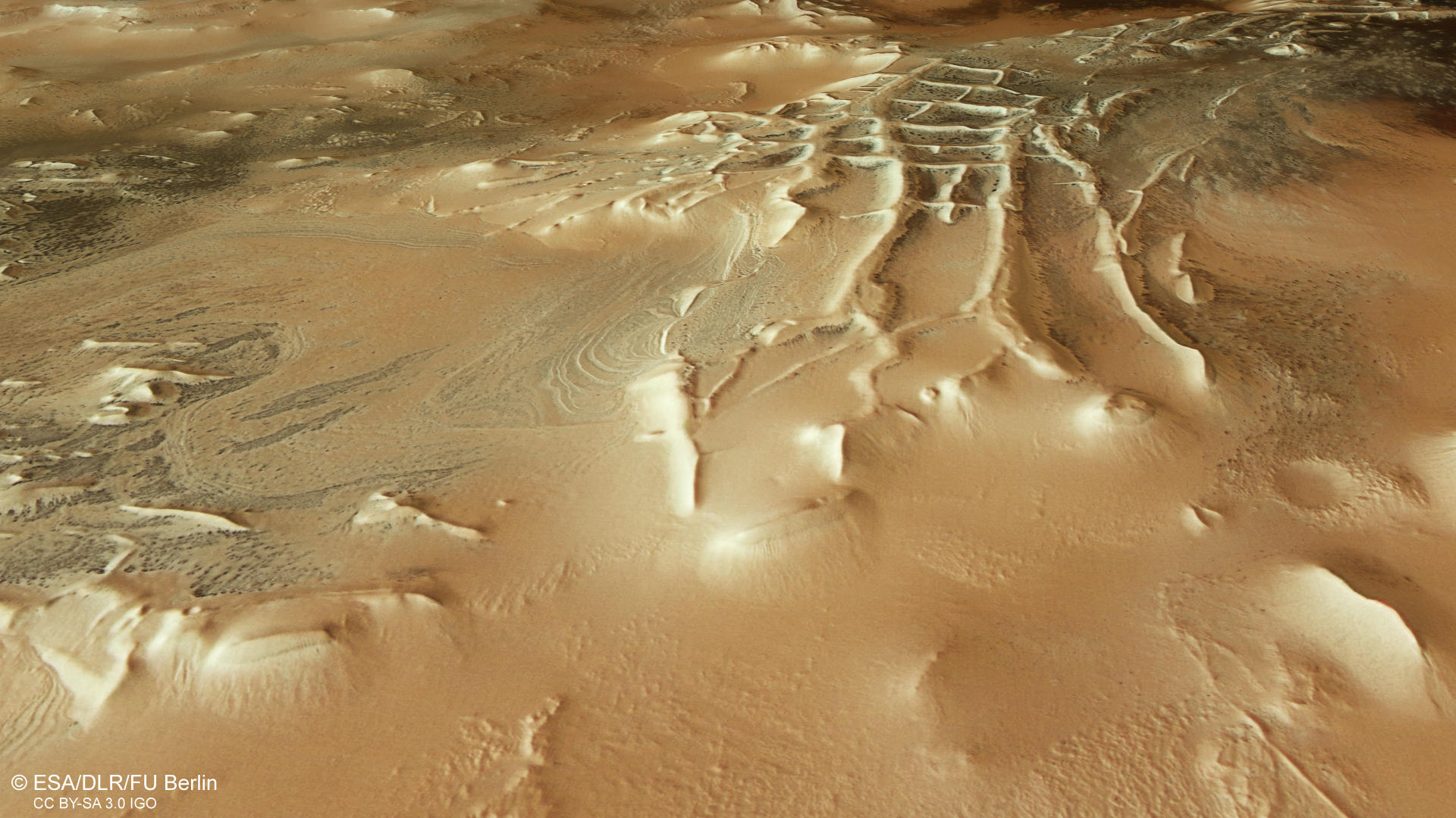
Polygonal ridge networks are found in numerous locations and geological contexts around Mars. The best-known example for these features is Angustus Labyrinthus near the South Pole. Discovered already in 1972 on Mariner 9 data, the structure exhibits a rectilinear pattern of ridges and internal polygons resembling Incan ruins and therefor it was informally named “Inca City”. The formation of these features is still discussed and ranges from lithified dunes to clastic dikes to magmatic dikes. Later data showed that the ridges trace the part of a large, 86 km in diameter circle, so researchers also supposed an exhumed impact basin structure. Deep faults, created by the impact filled up by rising lava. Later, the softer polar plains material around was eroded leaving back the harder ridges. Another hypothesis is that the ridges are linked to the neighboring Dorsa Argenta formation, which contains many ridge segments interpreted to be eskers, a glacial landform. The left part of the image shows the intriguing Angustus Labyrinthus feature.
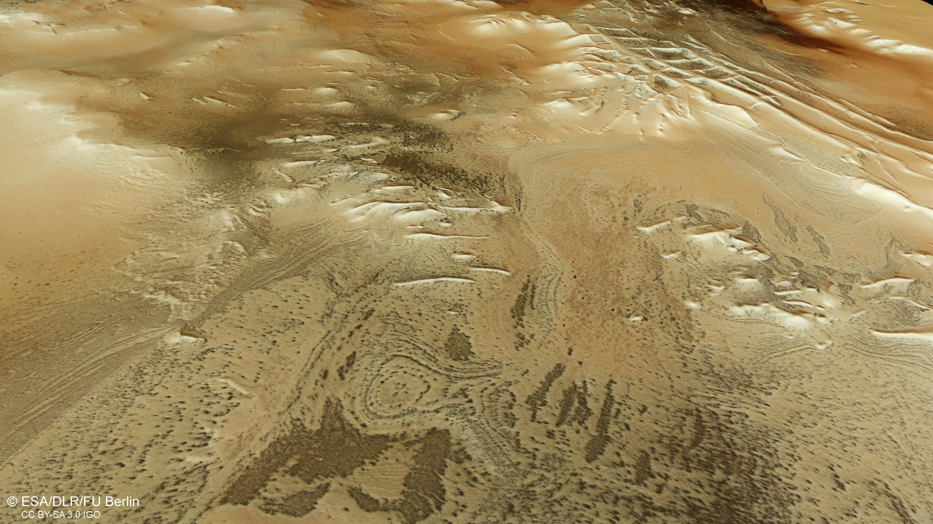
The south polar region of Mars displays an excessive abundance of exotic landforms, which mostly occur in regions covered by a seasonal ice cap. This HRSC observation shows a darker region on the left side (southern) side of the image. At closer look, this dark region is composed of many small dark spots which also can be found in all other parts of the image, but in different distributions.
They range in size from 45 m to 1 km and are believed to result from the escape of sand- and dust-laden carbon dioxide gas (CO2) from below a condensed slab of CO2 ice. When CO2 condenses at the south pole during late fall and winter, it forms a 0.5 to 1 m thick seasonal ice cap. A part of this ice condenses into a slab of solid larger grained CO2 ice. This ice slab is mostly translucent to the visible light and opaque to the thermal infrared spectrum. This means, that sunlight can pass through the ice layer and warm the underlying base causing sublimation. The pressurized gas is then trapped inside the (dark) substrate. When the pressure rises, the ice cracks and a rapid gas eruption takes place, entraining substrate material from the cavity and depositing the dark material at the surface.
It is assumed that this process represents an important exchange between the polar ice cap and the atmosphere. If one were to zoom in closer to the dark spots with even higher resolution images, one would discover thin lines starting from some of these spots. They are formed when the pressurized CO2 escapes along weak zones in the ice and the underlying material is deposited around the dark spot like spider legs. This is why these structures are also called "spiders" in mars research.”
Further towards the center of the image, the landscape changes and eroded layered deposits can be found, displaying large roundish and oval shapes. The center of the image is dominated by some buttes and large mesas raising more than 1500 meters. Interestingly, the dark spots can be found all over the image and at all altitudes even on top of the large mesas and also an some steep flanks. Further to the right (northern) part of the image, the dust coverage of the surface appears much higher. Finally, on the adjoining plateau many dark spots can be found again. There are also some canyons and troughs, presumably they are the witnesses of periodic sublimation.
High Resolution Stereo Camera (HRSC)
The images were acquired by the HRSC (High Resolution Stereo Camera) on 27 February 2024 during Mars Express Orbit 25449. The ground resolution is approximately 15 meter per pixel and the images are centered at about 300° East and 79° South. The color image was created using data from the nadir channel, the field of view which is aligned perpendicular to the surface of Mars, and the color channels of the HRSC. The oblique perspective view was generated from the digital terrain model, the nadir and color channels of HRSC. The anaglyph image, which creates a three-dimensional impression of the landscape when viewed with red/blue or red/green glasses, was derived from the nadir channel and one stereo channel. The color-coded topographic view is based on a digital terrain model (DTM) of the region, from which the topography of the landscape can be derived. The reference body for the HRSC-DTM is a Mars equipotential surface (Areoid).
HRSC is a camera experiment that was developed and is operated by the German Aerospace Center (Deutsches Zentrum für Luft- und Raumfahrt; DLR).The systematic processing of the camera data took place at the DLR Institute for Planetary Research in Berlin-Adlershof. The working group of Planetary Science and Remote Sensing at Freie Universität Berlin used the data to create the image products shown here.
To download released raw images and DTMs of the region in GIS-ready formats, follow this link to the mapserver link:
Images: ESA/DLR/FU Berlin, CC BY-SA 3.0 IGO
Copyright Notice:
Where expressly stated, images are licenced under the Creative Commons Attribution-ShareAlike 3.0 IGO (CC BY-SA 3.0 IGO) licence. The user is allowed to reproduce, distribute, adapt, translate and publicly perform it, without explicit permission, provided that the content is accompanied by an acknowledgement that the source is credited as 'ESA/DLR/FU Berlin', a direct link to the licence text is provided and that it is clearly indicated if changes were made to the original content. Adaptation / translation / derivatives must be distributed under the same licence terms as this publication.
The High Resolution Stereo Camera was developed at the German Aerospace Center (DLR) and built in collaboration with partners in industry (EADS Astrium, Lewicki Microelectronic GmbH and Jena-Optronik GmbH). The science team, which is headed by Principal Investigator (PI) Dr. Thomas Roatsch, consists of 52 co-investigators from 34 institutions and 11 countries. The camera is operated by the DLR Institute of Planetary Research in Berlin-Adlershof.