Department of Earth Sciences
Service Navigation
Ascraeus Mons South Flank - The Art of Ascraeus
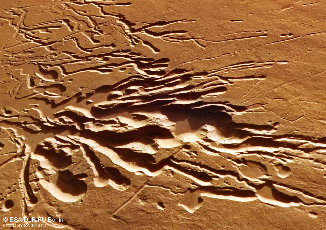
Image data, taken by the High Resolution Stereo Camera (HRSC) on board ESA’s Mars Express mission show a portion of the southern flank of Ascraeus Mons, the northernmost volcano of the Tharsis Montes volcano group. HRSC is a camera experiment that was developed and is operated by the German Aerospace Center (Deutsches Zentrum für Luft- und Raumfahrt; DLR).
» read more in the main article below...

Ascraeus Mons • Position & 3D view
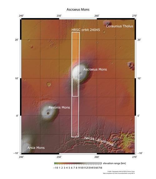
Ascraeus Mons - context map
Image Credit: MOLA Science Team/FU Berlin
Ascraeus Mons - 3D 1
Image Credit: ESA/DLR/FU Berlin
Ascraeus Mons - 3D 2
Image Credit: ESA/DLR/FU Berlin
Ascraeus Mons • HRSC images
Ascraeus Mons - HRSC color-coded terrain model
Image Credit: ESA/DLR/FU Berlin
Ascraeus Mons - HRSC color image
Image Credit: ESA/DLR/FU Berlin
Ascraeus Mons - HRSC annotated
Image Credit: ESA/DLR/FU Berlin
Ascraeus Mons - HRSC anaglyph
Image Credit: ESA/DLR/FU Berlin
Ascraeus Mons South Flank
Located in the Tharsis region of Mars, Ascraeus Mons is the northernmost and tallest of the three shield volcanoes known as the Tharsis Montes, which are aligned along a northeast-southwest oriented topographic high. With a diameter of roughly 480 km and a height of 18 km, Ascraeus Mons is the second highest mountain on Mars, only surpassed by the giant Olympus Mons. The volcano has a very low profile with an average flank slope of only 7°. The image shows a portion of the southern flank of Ascraeus Mons. The height difference from the left side (south) and the right side (north) of the image is about 10 km! The dramatic features shown here are named Ascraeus Chasmata, an enormous collapsed terrain, extending more than 70 km at the lower southern flank of the volcano.
Numerous geomorphologic structures of different age and origin can be found within the image. Starting at the right side of the image, still 60 km away from the summit of Ascraeus Mons, numerous lava flows can be spotted (see annotated image) partly better visible in the color-coded terrain image.
Pit structures, also called pit crater chains, can be found all over the HRSC scene (see annotated image for an example). Aligned circular to near circular depressions form chains and can combine to form a trough-like structure called coalesced pit crater troughs. It is consensus, that these structures are formed by collapse into a subsurface void. However various processes have been suggested as origin of these voids. They range from dyke-swarm emplacement and karst dissolution to tectonic and volcanic origin. Many researchers believe that these structures represent "lava tubes", which form when the lava flow cools quickly at the surface over a subsurface lava flow. The flow then eventually ceases and drains the tube, leaving back a void space several meters below the surface.
Sinuous rilles (see annotated image) are another common surface feature found at the flanks of volcanos. They are commonly smaller than the pit structures and describe rimless, sinuous channels. Volcanic processes such as ash flow erosion or lava flow emplacement, but also surface water flow and a combination of volcanic and water activity have been suggested as formation mechanisms for sinuous rilles.
The left side of the image is dominated by several large fissures, reaching length of up to 40 km. Braided channel networks emerge from these fissures. Along the channels, streamlined islands and terraces in the channel walls can be spotted (see annotated image). This suggests a formation by water and not by lava. Presumably snow/ice deposits accumulated on the flanks of the volcano and were buried under subsequent volcanic airfall deposits. They were then melted in a later active episode of Ascraeus Mons.
High Resolution Stereo Camera (HRSC)
The images were acquired by the HRSC (High Resolution Stereo Camera) on 15 January 2023 during Mars Express Orbits 24045. The ground resolution is approximately 16 meter per pixel and the image is centered at about 254° East and 9° North. The color image was created using data from the nadir channel, the field of view which is aligned perpendicular to the surface of Mars, and the color channels of the HRSC. The oblique perspective view was generated from the digital terrain model, the nadir and color channels of HRSC. The anaglyph image, which creates a three-dimensional impression of the landscape when viewed with red/blue or red/green glasses, was derived from the nadir channel and one stereo channel. The color-coded topographic view is based on a digital terrain model (DTM) of the region, from which the topography of the landscape can be derived. The reference body for the HRSC-DTM is a Mars equipotential surface (Areoid).
HRSC is a camera experiment that was developed and is operated by the German Aerospace Center (Deutsches Zentrum für Luft- und Raumfahrt; DLR). The systematic processing of the camera data took place at the DLR Institute for Planetary Research in Berlin-Adlershof. The working group of Planetary Science and Remote Sensing at Freie Universität Berlin used the data to create the image products shown here.
To download released raw images and DTMs of the region in GIS-ready formats, follow this link to the mapserver link:
Images: ESA/DLR/FU Berlin, CC BY-SA 3.0 IGO
Copyright Notice:
Where expressly stated, images are licenced under the Creative Commons Attribution-ShareAlike 3.0 IGO (CC BY-SA 3.0 IGO) licence. The user is allowed to reproduce, distribute, adapt, translate and publicly perform it, without explicit permission, provided that the content is accompanied by an acknowledgement that the source is credited as 'ESA/DLR/FU Berlin', a direct link to the licence text is provided and that it is clearly indicated if changes were made to the original content. Adaptation / translation / derivatives must be distributed under the same licence terms as this publication.
The High Resolution Stereo Camera was developed at the German Aerospace Center (DLR) and built in collaboration with partners in industry (EADS Astrium, Lewicki Microelectronic GmbH and Jena-Optronik GmbH). The science team, which is headed by Principal Investigator (PI) Dr. Thomas Roatsch, consists of 52 co-investigators from 34 institutions and 11 countries. The camera is operated by the DLR Institute of Planetary Research in Berlin-Adlershof.


