Department of Earth Sciences
Service Navigation
Utopia Planitia - The Frozen Beauty
Image data by the High Resolution Stereo Camera (HRSC) on board ESA’s Mars Express mission show multiple ice-related landforms in the Utopia Planitia region of Mars. The High Resolution Stereo Camera (HRSC) is a camera experiment that was developed and is operated by the German Aerospace Center (Deutsches Zentrum für Luft- und Raumfahrt; DLR).
» read more in the main article and below the gallery about Utopia Planitia ...
Utopia Planitia • Position & 3D view

Utopia Planitia map
Image Credit: MOLA Science Team/FU Berlin

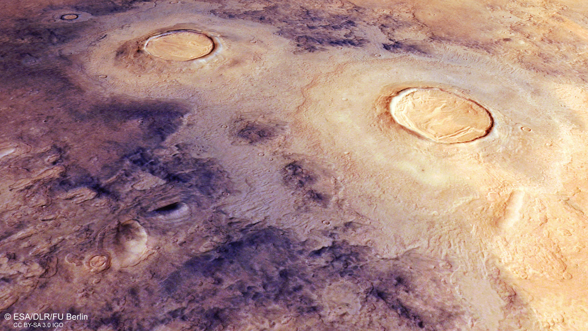
Utopia Planitia 3D
Image Credit: ESA/DLR/FU Berlin

Utopia Planitia 3D_2
Image Credit: ESA/DLR/FU Berlin
Utopia Planitia HRSC images

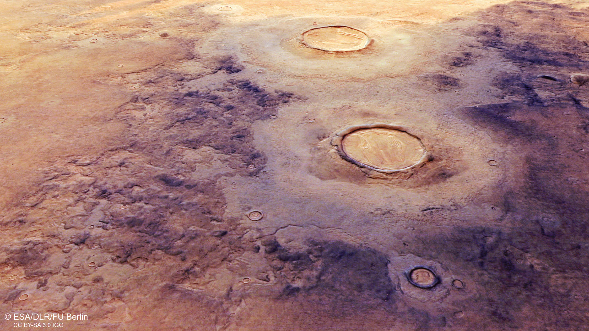
Utopia Planitia color image
Image Credit: ESA/DLR/FU Berlin

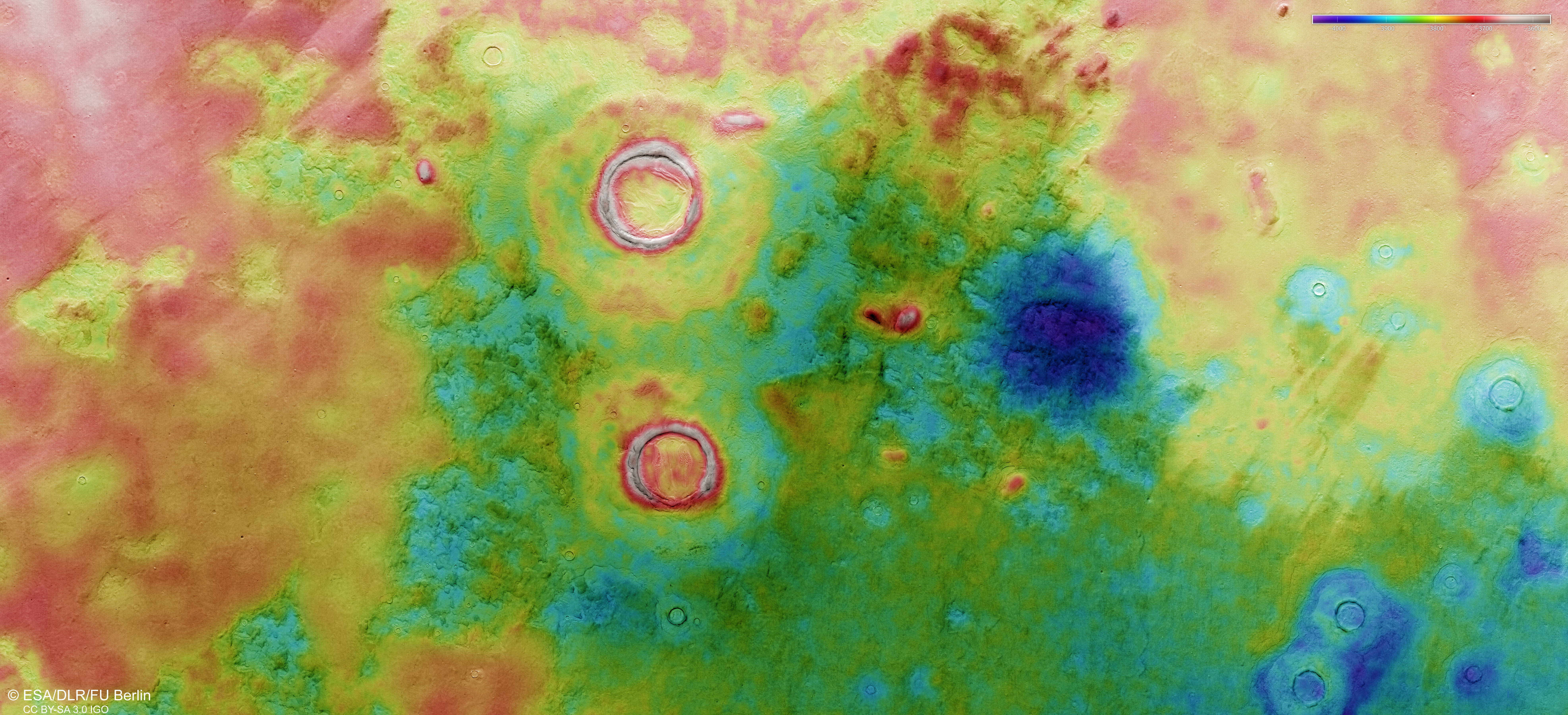
Utopia Planitia color-coded terrain model
Image Credit: ESA/DLR/FU Berlin

Utopia Planitia anaglyph
Image Credit: ESA/DLR/FU Berlin
Utopia Planitia - The Frozen Beauty
» read more about the Utopia Planitia
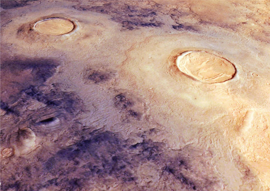
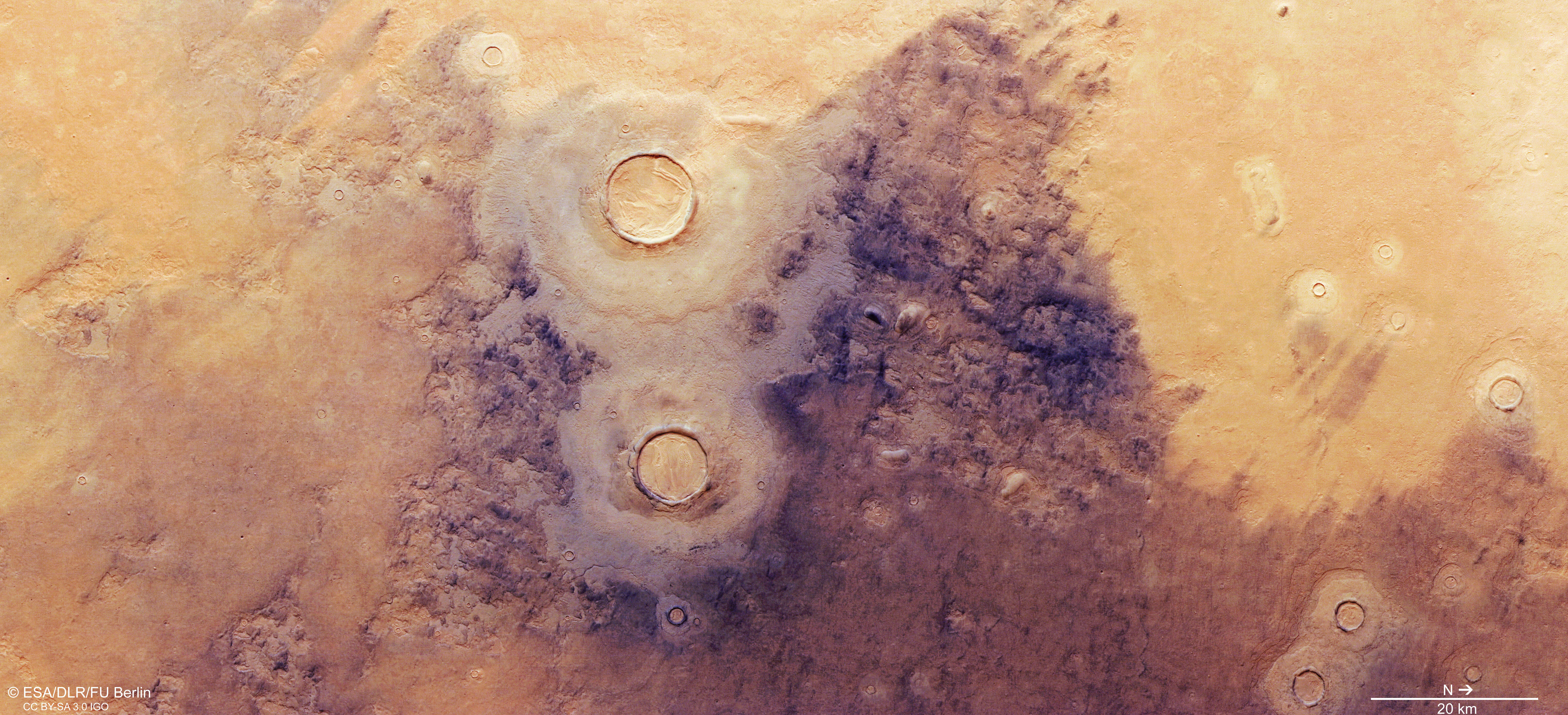
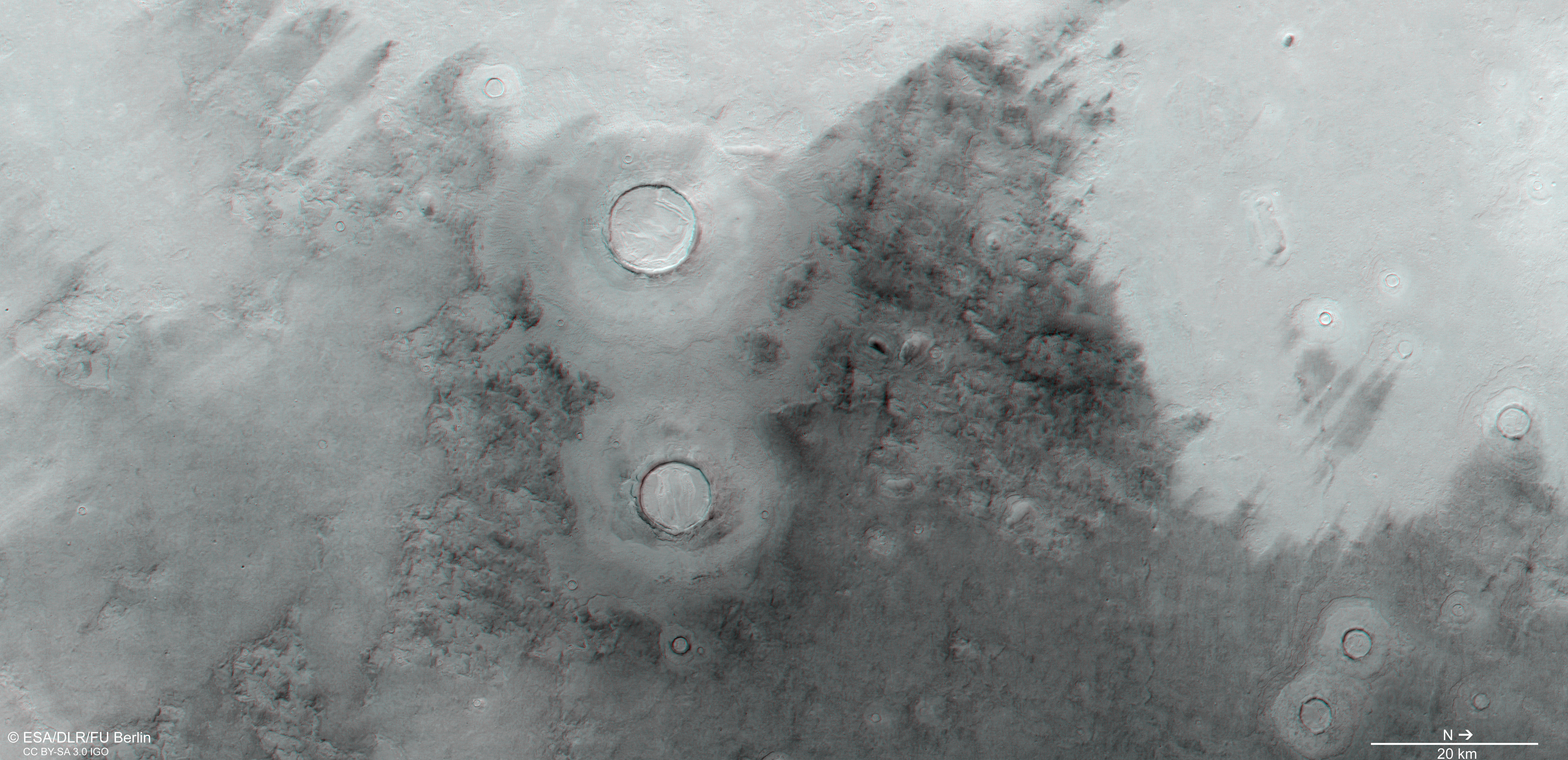
Mantled deposits are thick layers of ice- and dust-rich materials that are thought to have been deposited as snow at times when the angle of the tilt of Mars’ rotational axis was much higher, which last happened around 10 million years ago. As the name suggests, this dust/ice mixture covers and smoothens the surface like a mantle. It is very well visible as large patches at the left and right side of the image. The large impact craters in the image center display a double-layered ejecta blanket and at a closer look, the layered appearance of the mantling deposits can be seen at the crater rims and especially in the interior of the impact craters. Here it is called concentric crater fill and is also be found in the smaller craters around. The second largest crater in the image center showcases the typical so-called brain texture of the mantling with concentric deformation and locally the degradation by scallops and small pits.
Just to the right of the brain textured crater, a pattern is faintly visible in the dark colored regions. This pattern originates from fracturing by thermal contraction, which created a polygonal patterned ground. Wind-blown dark dust is trapped in the cracks and responsible for the dark coloration of this region.
Scalloped depressions are omnipresent throughout the image. They have circular to elliptical shapes and their size varies between tens of meters to several kilometers and depth of several tens of meters. They are the result of ground ice melting or its sublimation, followed by collapse of the surface. The process of subsidence by ice loss in the subsurface is called Thermokarst. At closer look, the layering of the mantled deposits can also be seen in and around the scalloped depressions.
Utopia Planitia is one of three major topographic basins in the northern hemisphere of Mars and shows a diameter 3,300 km. It is interpreted to represent an ancient impact basin, that was variably filled by a mix of sediments, volatiles and lavas, transported by water, wind and other processes. Ice in the subsurface has been confirmed by spectral measurements of the hydrogen abundance and directly by the Phoenix lander. Ground ice at greater depth has been detected by observations of fresh impact craters and sublimation pits, as well as by radar sounding.
High Resolution Stereo Camera (HRSC)
» information to image origin and processing
The images were acquired by the HRSC (High Resolution Stereo Camera) on 19 July 2021 during Mars Express Orbit 22173. The ground resolution is approximately 18 meters per pixel and the images are centered at about 257° East and 43° North. The color image was created using data from the nadir channel, the field of view which is aligned perpendicular to the surface of Mars, and the color channels of the HRSC. The anaglyph image, which creates a three-dimensional impression of the landscape when viewed with red/blue or red/green glasses, was derived from the nadir channel and one stereo channel. The oblique perspective view was generated from the digital terrain model, the nadir and color channels of HRSC. The color-coded topographic view is based on a digital terrain model (DTM) of the region, from which the topography of the landscape can be derived. The reference body for the HRSC-DTM is a Mars equipotential surface (Areoid).
HRSC is a camera experiment that was developed and is operated by the German Aerospace Center (Deutsches Zentrum für Luft- und Raumfahrt; DLR).The systematic processing of the camera data took place at the DLR Institute for Planetary Research in Berlin-Adlershof. The working group of Planetary Science and Remote Sensing at Freie Universität Berlin used the data to create the image products shown here.
To download released raw images and DTMs of the region in GIS-ready formats, follow this link to the mapserver.
Images: ESA/DLR/FU Berlin, CC BY-SA 3.0 IGO
Copyright Notice:
Where expressly stated, images are licenced under the Creative Commons Attribution-ShareAlike 3.0 IGO (CC BY-SA 3.0 IGO) licence. The user is allowed to reproduce, distribute, adapt, translate and publicly perform it, without explicit permission, provided that the content is accompanied by an acknowledgement that the source is credited as 'ESA/DLR/FU Berlin', a direct link to the licence text is provided and that it is clearly indicated if changes were made to the original content. Adaptation / translation / derivatives must be distributed under the same licence terms as this publication.
The High Resolution Stereo Camera was developed at the German Aerospace Center (DLR) and built in collaboration with partners in industry (EADS Astrium, Lewicki Microelectronic GmbH and Jena-Optronik GmbH). The science team, which is headed by Principal Investigator (PI) Dr. Thomas Roatsch, consists of 52 co-investigators from 34 institutions and 11 countries. The camera is operated by the DLR Institute of Planetary Research in Berlin-Adlershof.