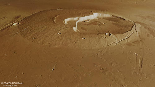
The Jovis Tholus Volcano - sunken in a lava sea
A long eruptive history
The Jovis Tholus shield volcano is located roughly in the middle between Olympus Mons and Ascreus Mons. It lies on the very northern edge of the lava plains surrounding the Tharsis Montes and is also bordered by the the Ceraunius Fossae fault system to the northeast and the Ulysses Fossae faults to the southwest. The about 1 km high volcano has a diameter of 58 km and shows a large off-center caldera complex some 28 km in diameter. It shows signs of a long eruptive history, because the caldera contains no less than 5 craters. These calderas align interconnected southwest from the first, the central caldera. Each younger caldera has a slightly lower floor. Like most tholi, Jovis Tholus is surrounded by younger lava flows, obscuring the original relief. These lavas also cover a set of buried graben which can be spotted all around the volcano. The eastern flank of Jovis Tholus is formed by a steep scarp of a north-trending graben. Some portions of this graben are exposed for several kilometers further north into the plains, however often buried by volcanic plains material. At closer look, individual lava flows can be found all over the plains.
Not only volcanic features
A very interesting feature lies just about 30 km east of the volcano flank. Here a second, less developed volcano rises (well visible in the color-coded image). Presumably less viscous flows erupted here from a so-called fissure vent, a structure also known from Iceland or Hawaii on Earth.
But not only volcanic features are present within this image mosaic. The large 30 km wide impact crater 60 km north of Jovis shows a so-called fluidized ejecta layer and a fractured crater floor. This means, that the impactor must have hit a water- or ice saturated ground to form this distinctive ejecta layer.
…but also flowing water
In addition to this, an outflow-channel system with individual beds measuring from 0.5 to 3.4 km in width emanates directly at the northwestern edge of the sharp graben fault bordering the impact crater (top left edge of the image). The waters were apparently released with bursts forming streamlined islands and terraced channel walls. Some much smaller channels can be found crosscutting the northern ejecta blanket of the large impact crater. Scientists suggest that these massive water amounts were released by perching of a groundwater aquifer while the buildup of the faults took place, or that volcanic warming led to melting of ground ice and the waters then took the easiest way to the surface through the graben system.
Taken all this together, this single HRSC image mosaic paints the picture of a fascinating active planetary history with impacts, volcanos, tectonic graben systems and also river channels.
Fun fact: Jovis Tholus would fit entirely into the caldera of Olympus Mons, the largest volcano in the solar system.
