Department of Earth Sciences
Service Navigation
Nilosyrtis Mensae - Erosion on a large scale
Image data by the High Resolution Stereo Camera (HRSC) on board ESA’s Mars Express mission show a landscape that has been strongly overprinted by crater degradation and valley incision. HRSC is a camera experiment that was developed and is operated by the German Aerospace Center (Deutsches Zentrum für Luft- und Raumfahrt; DLR).
» read more in the main article and below the gallery about Nilosyrtis Mensae ...
Nilosyrtis Mensae • Location and Scheme

context map
Image Credit: MOLA Science Team/FU Berlin

Scheme for the formation of block glaciers in Nilosyrtis Mensae
Image Credit: modified after van Gasselt 2011
Nilosyrtis Mensae • Images

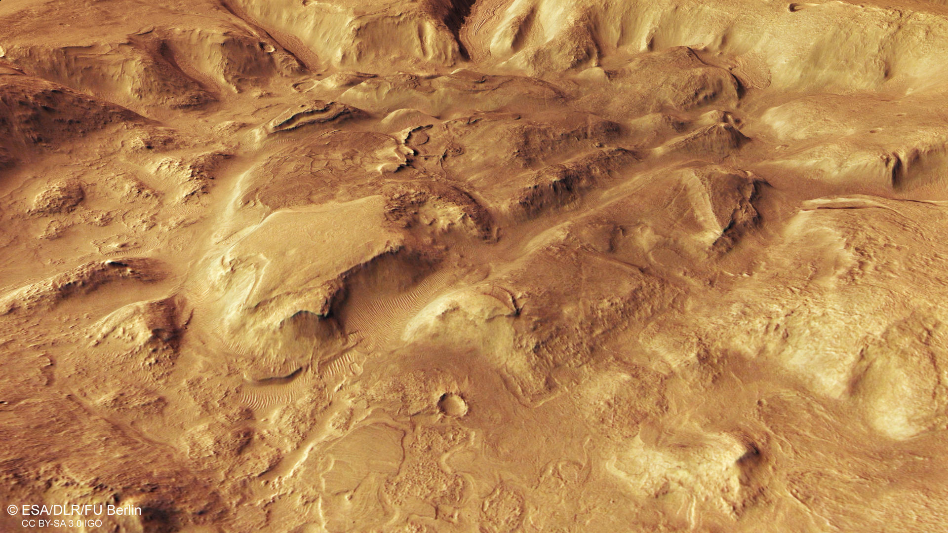
HRSC color image
Image Credit: ESA/DLR/FU Berlin

HRSC color-coded terrain model
Image Credit: ESA/DLR/FU Berlin

HRSC anaglyph
Image Credit: ESA/DLR/FU Berlin
Nilosyrtis Mensae - Erosion on a large scale
» read more about Nilosyrtis Mensae on Mars
The northern and southern hemisphere of Mars are fundamentally different with respect to their surface topography, age, and morphology. The northern hemisphere is smooth and has lower elevations compared to the heavily cratered high-standing southern hemisphere. An escarpment that marks a topographic difference of several kilometers characterizes the transition zone between both. The landscape in this region has been deeply dissected through the action of water, wind, and ice.
The region Nilosyrtis Mensae is delineated fretted terrain, because of its numerous labyrinth-like valleys that often exhibit viscous flow features. Dissection by water and ice left rounded hills and mesas. Many landforms throughout the image have a softened appearance attributed to extensive degradation. The former impact crater to the right of the image was flattened and widened over time due to fluvial erosion and infilling with sediments, so that the crater relief nearly disappeared.
The valley floors especially in the northern part of the image show linear ridges and grooves that can be traced along the course of flow. These textures suggest that icy material once slowly flowed down the valleys, possibly in the form of debris-covered glaciers similar to rock glaciers found on Earth. Rock glaciers are bodies of ice interspersed with boulders and rocky debris found primarily in regions of permafrost on high mountain ranges or at polar latitudes. The glacier-like deposits could represent leftovers of a retreating ice sheet that has covered the region during recent Martian ice ages. Former climatic conditions on Mars obviously.
High Resolution Stereo Camera (HRSC)
» information to image origin and processing
The images were acquired by the HRSC (High Resolution Stereo Camera) on 29 September 2019 during Mars Express Orbit 19908. The ground resolution is approximately 15 meters per pixel and the images are centered at about 69° East and 31° North. The color image was created using data from the nadir channel, the field of view which is aligned perpendicular to the surface of Mars, and the color channels of the HRSC. The oblique perspective view was generated from the digital terrain model, the nadir and color channels of HRSC. The anaglyph, which provides a three-dimensional view of the landscape when viewed using red-green or red-blue glasses, was derived from data acquired by the nadir channel and the stereo channels. The color-coded topographic view is based on a digital terrain model (DTM) of the region, from which the topography of the landscape can be derived. The reference body for the HRSC-DTM is a Mars equipotential surface (Areoid).
HRSC is a camera experiment that was developed and is operated by the German Aerospace Center (Deutsches Zentrum für Luft- und Raumfahrt; DLR).The systematic processing of the camera data took place at the DLR Institute for Planetary Research in Berlin-Adlershof. The working group of Planetary Science and Remote Sensing at Freie Universität Berlin used the data to create the image products shown here.
To download released raw images and DTMs of the region in GIS-ready formats, follow this link to the mapserver.
Images: ESA/DLR/FU Berlin, CC BY-SA 3.0 IGO
Copyright Notice:
Where expressly stated, images are licenced under the Creative Commons Attribution-ShareAlike 3.0 IGO (CC BY-SA 3.0 IGO) licence. The user is allowed to reproduce, distribute, adapt, translate and publicly perform it, without explicit permission, provided that the content is accompanied by an acknowledgement that the source is credited as 'ESA/DLR/FU Berlin', a direct link to the licence text is provided and that it is clearly indicated if changes were made to the original content. Adaptation / translation / derivatives must be distributed under the same licence terms as this publication.
The High Resolution Stereo Camera was developed at the German Aerospace Center (DLR) and built in collaboration with partners in industry (EADS Astrium, Lewicki Microelectronic GmbH and Jena-Optronik GmbH). The science team, which is headed by Principal Investigator (PI) Prof. Dr. Ralf Jaumann, consists of 52 co-investigators from 34 institutions and 11 countries. The camera is operated by the DLR Institute of Planetary Research in Berlin-Adlershof.