Mars crater Moreux and its dark dunes
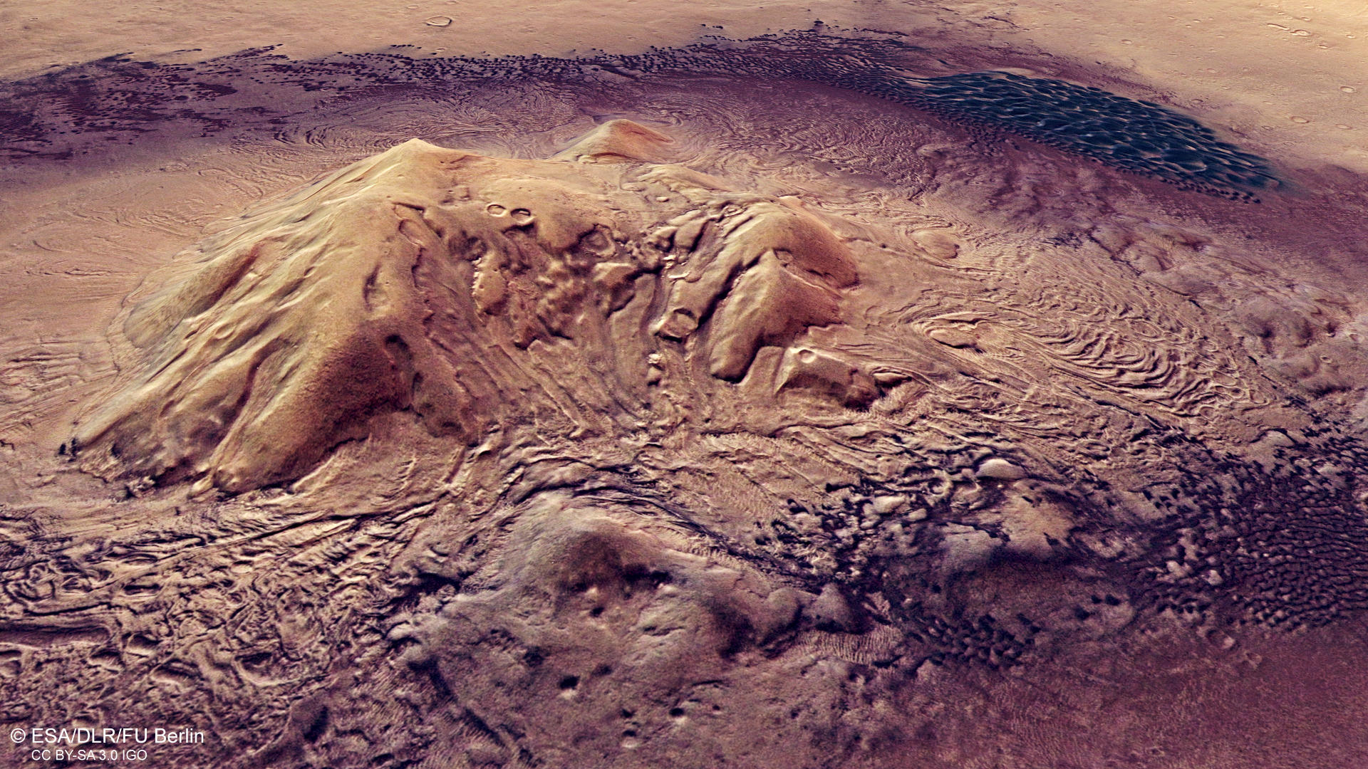
Moreux Crater on Mars has a diameter of 135 kilometers and a depth of three kilometers measured from the rim. It is located in the Protonilus region at the Martian highland-lowland boundary. The rim and floor of Moreux Crater have undergone substantial glacial modification within the last millions of years. Lobate flow features of ice-rich debris around the central peak and in the southern part of the crater point to recent and episodic glacial activity.
Formed by glaciers …
Ice-rich material has left behind a diverse glacial treasure trove, which can be found mainly around the central peak and along the crater rim. This includes numerous valleys that carve into the flanks. Polygonal structures at the bottom of these valleys have been interpreted as patterned ground, or periglacial landforms. Linear valley fillings, such as in the wide valley at the southern crater rim, were created by the meeting of ice and scree masses that once slid down the valley slopes and met in the middle of the valley. Tongue-shaped deposits and viscous flow patterns are remnants of rock glaciers that formed almost everywhere along the crater wall.
Dating of these terrain forms has revealed that glacial and periglacial processes occurred here repeatedly during a period that lasted from approximately one billion to 400,000 years ago. Moreux Crater is situated at 41.6 degrees north, in the mid-latitudes of Mars, where glaciation processes occurred mainly when the axis of rotation of Mars was tilted at a greater angle than it is today (currently the inclination is 25.2 degrees) and the poles, with their ice caps, were tilted more directly towards to the Sun. Then, at mid-latitudes, more ice and snow from the atmosphere was deposited on crater edges and plateaus, where it collected and formed glaciers.
… and gone with the wind
The two-kilometre-high central peak in the crater is surrounded by dark, sandy material. Winds have piled it up into groups of individual dunes and also into contiguous dune fields. The grey-black dunes (they only appear bluish in these contrast-enhanced colour images) consist of volcanic sand and fine ash with a basalt composition. This is mainly comprised of the minerals olivine and pyroxene, which cause the dark colouring of basaltic materials. Both minerals are silicates and have a high content of magnesium and iron.
The dune fields in Moreux Crater show slight colour variations, possibly caused by differences in the composition of the dunes. The OMEGA spectrometer on Mars Express can be used to investigate the mineralogical composition of surface materials. The large contiguous dune field to the north of the central peak was found to have a significantly higher olivine content than the rest of the dunes, which are predominantly composed of pyroxene.
In addition to the glacial formations, the crater also has aeolian formations that are visible in the different dune shapes. The most common type of dune is crescent-shaped (referred to as a barchan) which, when they grow together and merge, form barchanoidal ridges. The dune fields in Moreux Crater are made up of these ridges. Barchans are generally associated with limited sediment availability and a unimodal wind regime – this is, they are formed by wind that always blows from the same direction.
However, orientation of the dunes varies in different regions of the crater, which indicates a complex system of prevailing wind directions. This is due to the specific topography of the crater and its central peak. The large barchanoidal dune field to the north of the central peak is primarily formed by winds from the northeast. At its southern end, winds from the northwest meet the dunes and create star dunes, which are typically formed by winds from different directions.
If one follows the dune shapes counterclockwise from there, around the central peak, and uses them to discern the wind directions, the winds follow a semicircle. First, they come from the northwest, then the west, and later from the southwest until one reaches the eastern side of the dune ring. Here, downdrafts from the west blowing from the slopes of the central peak meet winds from the east coming from the crater rim. The barchanoidal ridges change into transverse dunes at this point. Moreux Crater is thus a prime example of how local topography can influence wind flows and thereby have an indirect influence on morphological features.