Department of Earth Sciences
Service Navigation
First Topographic Map of Jezero Crater - Mars 2020 Landing Site
The images shown here were derived from a mosaic of images calculated single orbit observations taken by the High Resolution Stereo Camera (HRSC) on board ESA's Mars Express spacecraft. The map shows the landing site of the "Perseverance" rover of the NASA Mars 2020 mission. HRSC is a camera experiment that was developed and is operated by the German Aerospace Center (Deutsches Zentrum für Luft- und Raumfahrt; DLR).
» read more in the main article and below the gallery about the first Topographic map ...
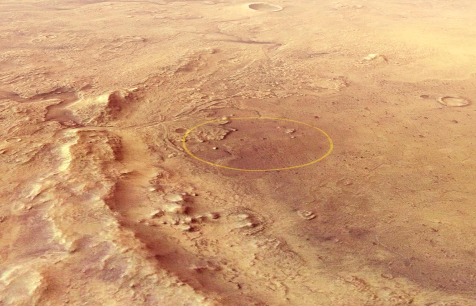
Jezero Crater • Context Map

Jezero Crater Image
Image Credit: ESA/DLR/FU Berlin
Jezero Crater • Map and Profile

Jezero Crater Topographic Map
Image Credit: ESA/DLR/FU Berlin
First Topographic Map of Jezero Crater
» read more about the Topographic Map of Jezero Crater
The goal of NASA’s Mars2020 mission is to explore the history of water and chemistry in an ancient crater lake basin and associated river-delta environments to probe early Martian climates and search for life. The mission is set to land on 18 February 2021 in Jezero crater. The planned landing area is marked with an ellipse (landing site ellipse = LSE). On board: The NASA rover “Perseverance”. The 1,025 kg heavy rover is the most complex equipment ever sent to Mars. Besides numerous scientific instruments, it will carry containers for a drill core sample collection that will be left on Mars for a later return to Earth carried out by follow-up missions planned for the 2030s. The rover also carries a 1.8 kg helicopter drone named “Ingenuity” as technology demonstrator and near field reconnaissance instrument.
Link to: Flight over the Jezero Crater - NASA's Mars 2020 landing site
Jezero crater is a Noachian crater that once contained a paleolake and deltas (marked as lacustrine fan delta = LFD) that were fed by large regional watersheds. Two inlet valleys can be spotted in the northern and northeastern part of the crater. The HRSC map clearly shows a much smoother topography of the northern part of the crater floor compared to the much steeper crater rims in the southern part. Materials eroded from the large catchment area north of the crater were transported and deposited inside Jezero, building up the deltas and smoothing out the floor. A large outlet channel is located at the eastern part of the crater and shows a swell at the rim of the crater. This means that there must have been a relatively constant supply of water into the crater to carve such a large outlet valley and that some water always remained behind the swell, in the crater lake. This is very well visible in the profiles starting with the inlet channels (In1 and In2), merging in the central basin, passing over the swell into the outlet channel (Out1).
The floor of Jezero crater has an elevation of 2,700 metres below the notional 'sea level' on Mars. Strictly speaking, this reference level, which is used on the map shown here, is a surface of equal gravitational attraction, referred to as an areoid. The lake in Jezero crater is thought to have been at least 250 metres deep (with a size of approximately 1,340 km²), a figure derived from the altitude measurements for the crater rim, the crater floor, the river valley profile and the upper edges of the deltas. However, it is no longer possible to make precise estimates today, as the deltas have been severely eroded since water activity ceased approximately 3.8 billion years ago. In addition, the crater was filled with very extensive lava flows from the nearby Syrtis Major region about 300 million years later.
The topographical map clearly shows how the northern part of the crater floor is sloping and this results in a less clearly defined crater rim when compared to the flat, southern part of the crater floor and the steeper southern flanks. This is due to the erosion of material in the catchment areas to the north of the crater, which was then transported into the crater itself and deposited as sediments in the delta. The erosion of the northern crater rim by the three river valleys that break through it also contributed to the creation of Jezero's asymmetrical topography.
Clay minerals, particularly carbonates, which have been discovered in comparatively large quantities in the western delta, are significant as potential repositories of biosignatures – that is, traces of microbial life. The early presence of liquid water and the enormous carbonate deposits here make Jezero a perfect destination for the search for possible past life on Mars.
High Resolution Stereo Camera (HRSC)
» information to image origin and processing
The map shown here was created using an image mosaic made from single orbit observations of the High Resolution Stereo Camera (HRSC) on board ESA’s Mars Express mission. The color mosaic consists of two orbit strips (5252, 5270) and covers an area at about 18 degrees latitude and 77 degrees longitude north of the Martian equator. The color-coded topographic map is based on a digital terrain model (DTM) of the region, from which the topography of the landscape can be derived. The reference body for the HRSC-DTM is a Mars equipotential surface (Areoid).
HRSC is a camera experiment that was developed and is operated by the German Aerospace Center (Deutsches Zentrum für Luft- und Raumfahrt; DLR).The systematic processing of the camera data took place at the DLR Institute for Planetary Research in Berlin-Adlershof. The working group of Planetary Science and Remote Sensing at Freie Universität Berlin used the data to create the image products shown here.
To download released raw images and DTMs of the region in GIS-ready formats, follow this link to the mapserver.
Images: ESA/DLR/FU Berlin, CC BY-SA 3.0 IGO
Copyright Notice:
Where expressly stated, images are licenced under the Creative Commons Attribution-ShareAlike 3.0 IGO (CC BY-SA 3.0 IGO) licence. The user is allowed to reproduce, distribute, adapt, translate and publicly perform it, without explicit permission, provided that the content is accompanied by an acknowledgement that the source is credited as 'ESA/DLR/FU Berlin', a direct link to the licence text is provided and that it is clearly indicated if changes were made to the original content. Adaptation / translation / derivatives must be distributed under the same licence terms as this publication.
The High Resolution Stereo Camera was developed at the German Aerospace Center (DLR) and built in collaboration with partners in industry (EADS Astrium, Lewicki Microelectronic GmbH and Jena-Optronik GmbH). The science team, which is headed by Principal Investigator (PI) Prof. Dr. Ralf Jaumann, consists of 52 co-investigators from 34 institutions and 11 countries. The camera is operated by the DLR Institute of Planetary Research in Berlin-Adlershof.