Department of Earth Sciences
Service Navigation
Dark meets light on Mars
Fluvial valleys, mesas, and areas covered by different-colored dust and sand characterize the presented images of the High Resolution Stereo Camera (HRSC), displaying a region in Terra Cimmeria in the southern highlands of Mars. HRSC is a camera experiment that was developed and is operated by the German Aerospace Center (Deutsches Zentrum für Luft- und Raumfahrt; DLR), and mounted on board the ESA Mars Express mission, orbiting Mars since 2003.
» Read more about Terra Cimmeria in the main article and below the gallery
Terra Cimmeria • Images

HRSC color image
Image Credit: ESA/DLR/FU Berlin

HRSC color-coded terrain model
Image Credit: ESA/DLR/FU Berlin
Terra Cimmeria • Anaglyph and Location

HRSC anaglyph
Image Credit: ESA/DLR/FU Berlin

context map
Image Credit: MOLA Science Team/FU Berlin
Dark meets light on Mars
» Read more about Terra Cimmeria
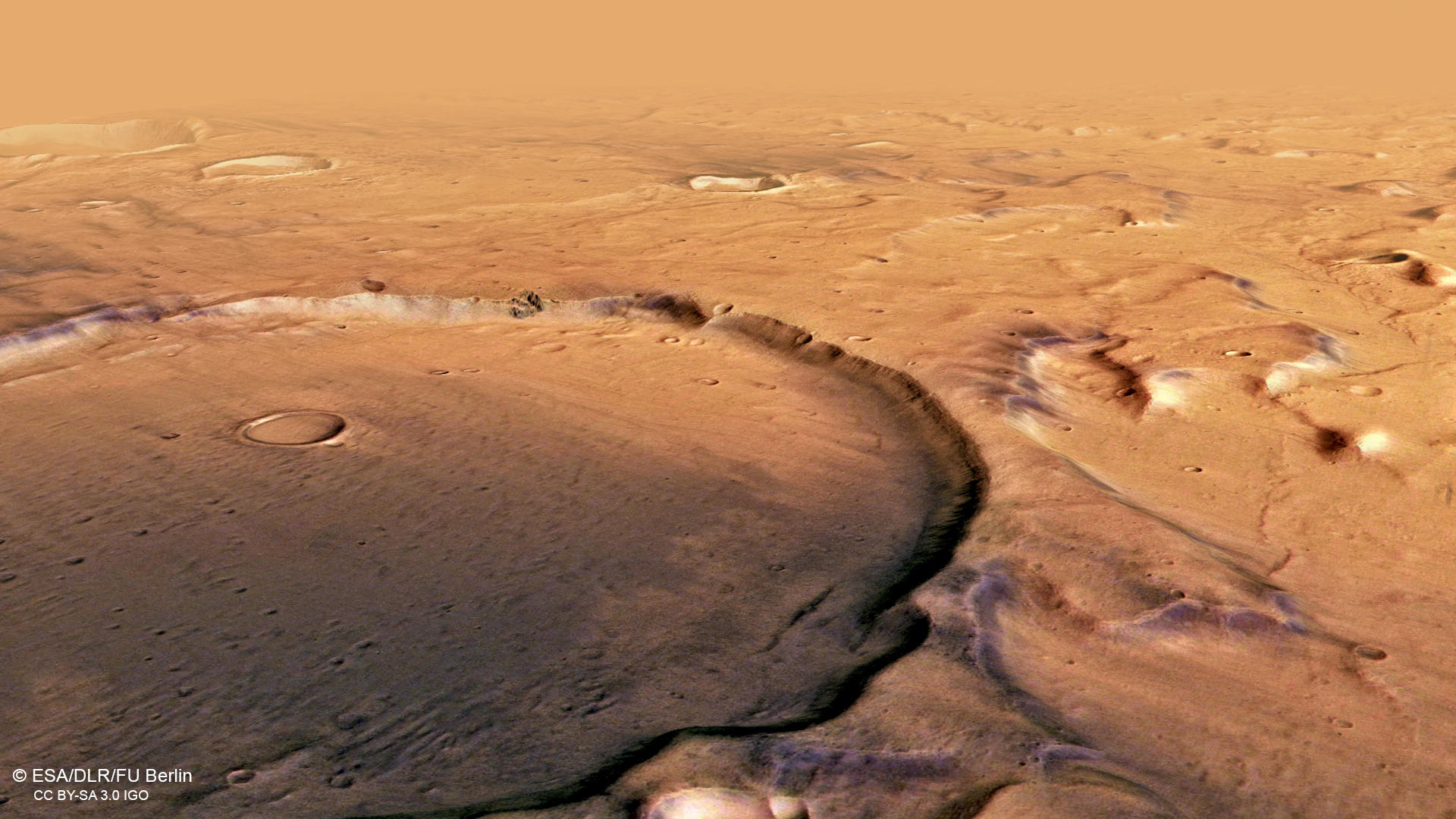
Bright and dark regions on Mars can actually be distinguished from Earth by telescope. They differ by composition and particle size: bright regions are mostly covered by fine dust from silicate minerals, whereas dark regions are dominated by mafic minerals found for instance in basalt, which represents the most common volcanic rock found on the Red Planet. Layers of basaltic sands, as seen in the northern (right) part of the color image, probably originated from volcanic ashes and elsewhere form imposing dune fields in various places on Mars. Five large volcanic provinces and countless small, scattered volcanoes have distributed ash layers all over Mars, later concealed beneath other rocky material. When exposed at slopes, such as in impact craters, the ash can be carried out by wind and deposited over wide areas.
The largest impact crater in the image has a diameter of 25 kilometers, but is only about 300 meters deep, probably because it has been filled by volcanic or sedimentary deposits. Mesas south of the impact crater and valleys in the near vicinity are remnants of a former widespread fluvial system in the Terra Cimmeria region. Recent studies point to surface runoff of ice or snow melt, probably during several episodic glacial-related events, as the source of water. The cap rock forming the mesas might originate from eolian deposits, comparable to airfall deposits in China forming loess up to several hundred meters thick. Numerous valley networks locally crosscut these deposits, as seen for instance north (right) of the impact crater. They most likely dewatered into the putative ancient Eridania sea, connecting the lower-elevation provinces north of the presented region.
In the southern (left) part of the image, numerous dark dust devil tracks are identified. They form when eddies remove the uppermost dust layer which has a slightly different color than the now- exposed surface. Dust devil tracks are the short - lived witnesses of the ongoing geologic and atmospheric activity on Mars, which consists mainly of the transport of dust by wind.
High Resolution Stereo Camera (HRSC)
» Information to image origin and processing
The images were acquired by the HRSC (High Resolution Stereo Camera) on 11 December 2018 during Mars Express Orbit 18904. The ground resolution is approximately 13 meters per pixel and the images are centered at about 171° East and 40° South. The color image was created using data from the nadir channel, the field of view which is aligned perpendicular to the surface of Mars, and the color channels of the HRSC. The oblique perspective view was generated from the digital terrain model, the nadir and color channels of HRSC. The anaglyph, which provides a three-dimensional view of the landscape when viewed using red-green or red-blue glasses, was derived from data acquired by the nadir channel and the stereo channels. The color-coded topographic view is based on a digital terrain model (DTM) of the region, from which the topography of the landscape can be derived. The reference body for the HRSC-DTM is a Mars equipotential surface (Areoid).
The systematic processing of the camera data took place at the DLR Institute for Planetary Research in Berlin-Adlershof. The working group of Planetary Science and Remote Sensing at Freie Universität Berlin used the data to create the image products shown here.
Images: ESA/DLR/FU Berlin, CC BY-SA 3.0 IGO
Copyright Notice:
Where expressly stated, images are licenced under the Creative Commons Attribution-ShareAlike 3.0 IGO (CC BY-SA 3.0 IGO) licence. The user is allowed to reproduce, distribute, adapt, translate and publicly perform it, without explicit permission, provided that the content is accompanied by an acknowledgement that the source is credited as 'ESA/DLR/FU Berlin', a direct link to the licence text is provided and that it is clearly indicated if changes were made to the original content. Adaptation / translation / derivatives must be distributed under the same licence terms as this publication.
The High Resolution Stereo Camera was developed at the German Aerospace Center (DLR) and built in collaboration with partners in industry (EADS Astrium, Lewicki Microelectronic GmbH and Jena-Optronik GmbH). The science team, which is headed by Principal Investigator (PI) Prof. Dr. Ralf Jaumann, consists of 52 co-investigators from 34 institutions and 11 countries. The camera is operated by the DLR Institute of Planetary Research in Berlin-Adlershof.