Department of Earth Sciences
Service Navigation
Major crater pays tribute to a leading planetary scientist
These images acquired by the DLR-operated High Resolution Stereo Camera (HRSC) on board the ESA Mars Express spacecraft show Greeley Crater on Mars. It was named after the US scientist Ronald Greeley, who passed away in 2011. In addition to being a pioneer in the field of planetary geology, he was a member of the HRSC experiment team from the very outset, and was also Co-investigator of the HRSC.
» Read more about Greeley Crater and to Ronald Greeley in person in the main article (below the gallery) ...
» Press Release of Arizona State University
Greeley Crater • Views

HRSC color image
Image Credit: ESA/DLR/FU Berlin

HRSC color-coded terrain model
Image Credit: ESA/DLR/FU Berlin
Greeley Crater • Location and Perspective

Context map
Image Credit: MOLA Science Team/FU Berlin

HRSC perspective
Image Credit: ESA/DLR/FU Berlin
Greeley – major crater pays tribute to a leading planetary scientist
» Read more about the impact crater and the person Ronald Greeley
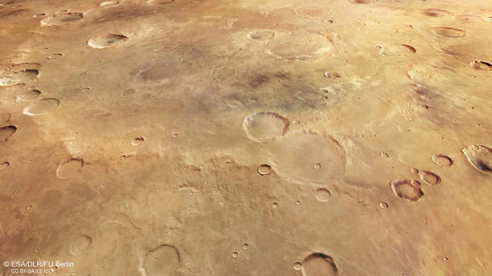
In 2015 the International Astronomical Union (IAU) named the impact crater shown in this image mosaic from the High Resolution Stereo Camera (HRSC) after the US scientist Ronald Greeley, who passed away in 2011. Greeley was a pioneer in the field of planetary geology, which he taught and researched at Arizona State University from 1977 onwards. From the very outset, in 1988, Greeley was also a member of the HRSC experiment team –first on the unsuccessful Russian mission Mars 96 and then on the follow-up Mars Express mission, operated by the European Space Agency (ESA).
Greeley Impact Crater is located in Noachis Terra, an area of the southern highlands between the Argyre and Hellas Planitia impact basins and, with a diameter of 427 kilometres, is one of the largest impact craters on Mars. This ancient crater, which has already been heavily eroded and filled with sediment, is difficult to make out against the Martian landscape due to its relatively shallow depth of only 1.5 kilometres – indeed, the crater rim has disappeared altogether in places. An astronaut standing in the middle of the crater would not be able to see the crater rim on the horizon at all due to the curvature of Mars, which is greater than Earth’s. The crater outline is most visible on the colour-coded digital terrain model.
With an age of up to four billion years, Noachis Terra is one of Mars’ oldest regions. Countless impact craters of different sizes were formed and later eroded here over the course of billions of years. Through these erosion processes, impact craters that had once been trough-shaped were worn away over time by wind, water or ice into shallow depressions devoid of relief. The lack of ejected material, the low and partially non-existent crater rim, the flat crater floor and the numerous impact craters within it indicate that Greeley Crater is very old. A closer look reveals a myriad of tiny craters here and there. Known as secondary craters, these are a result of the impact of material ejected when other objects hit the planet’s surface. Small, narrow gullies cross some of the larger inner craters, indicating that water once flowed within the crater. Other wider channels suggest that masses of ice loaded with sediment once crept down the slopes. The different colouration of the material on the crater floor is due to the differences in composition – the lighter material was weathered through water and the darker surfaces covered by volcanic sands.

Ronald Greeley
Image Credit: Arizona State University, Tom Story
Ronald Greeley’s passion was Mars science. Not only was he a co-investigator for the Mars Express HRSC, but he was also involved in other Mars missions, such as Mariner, Viking, Pathfinder, Mars Global Surveyor and the Mars Exploration Rovers Spirit and Opportunity. His career in planetary research began in 1967 at NASA AMES Research Center, where he studied volcanic landforms and lava tubes on Earth and the Moon. He later worked with planetary mission data acquired by Galileo for Jupiter, Magellan for Venus, and Voyager 2 for Uranus and Neptune. He was also interested in surface features and processes that occur due to the effects of wind on other planets. In 1977 he became Professor of the School of Earth and Space Exploration at Arizona State University, where he created the Planetary Aeolian Laboratory, which is still running to this day. Atmospheric processes on planets were researched in closer detail here using a wind tunnel and a device that could generate vortex motion.
Ronald Greeley passed away on 27 October 2011 as an internationally renowned and distinguished scientist. In 2015 the International Astronomical Union (IAU) named this Martian crater in his honour. Further, the Ronald Greeley Center Center for Planetary Studies (RGCPS), at Arizona State University, Tempe, is one in a network of 16 Regional Planetary Image Facility (RPIF) data centers, established by NASA to archive planetary images for use by the scientific and educational communities. The RGCPS began as the Space Photography Laboratory (SPL), established by Dr. Ronald Greeley when he moved from the NASA-Ames Research Center to Arizona State University in 1977. Prof. Ronald Greeley was the Director of the SPL until he passed away in 2011. Prof. David A. Williams is the current director of the facility, which has since been renamed the Ronald Greeley Center for Planetary Studies.
“Ron Greeley’s colleagues at Arizona State University are so honored with this HRSC product of Greeley Crater on Mars,” said Dr. David Williams, Associate Research Professor in ASU’s School of Earth and Space Exploration and an HRSC Co-Investigator. “We even have a rendition of this HRSC mosaic of Greeley Crater in our newly-renovated Ronald Greeley Center for Planetary Studies, the NASA Regional Planetary Information Facility at ASU”.
High Resolution Stereo Camera (HRSC)
» Information to image origin and processing
The mosaic consists of 16 orbit strips (0430, 1910, 1932, 2412, 2467, 2478, 4306, 4317, 4328, 6556, 8613, 8620, 8708, 12835, 14719, 16778) and covers a region 2° West - 9° East and 31.5° - 43.5° South. The mosaic resolution is approximately 100 meters per pixel. The color mosaic was created using data from the nadir channels, the fields of view which are aligned perpendicular to the surface of Mars, and the color channels of the HRSC. The oblique perspective view was generated using data from the HRSC stereo channels. The color-coded topographic view is based on a digital terrain model (DTM) of the region, from which the topography of the landscape can be derived. The reference body for the digital terrain model is a Mars equipotential surface (Areoid).
The systematic processing of the camera data took place at the DLR Institute for Planetary Research in Berlin-Adlershof. The working group of Planetary Science and Remote Sensing at Freie Universität Berlin used the data to create the image products shown here.
Images: ESA/DLR/FU Berlin, CC BY-SA 3.0 IGO
Copyright Notice:
Where expressly stated, images are licenced under the Creative Commons Attribution-ShareAlike 3.0 IGO (CC BY-SA 3.0 IGO) licence. The user is allowed to reproduce, distribute, adapt, translate and publicly perform it, without explicit permission, provided that the content is accompanied by an acknowledgement that the source is credited as 'ESA/DLR/FU Berlin', a direct link to the licence text is provided and that it is clearly indicated if changes were made to the original content. Adaptation / translation / derivatives must be distributed under the same licence terms as this publication.
The High Resolution Stereo Camera was developed at the German Aerospace Center (DLR) and built in collaboration with partners in industry (EADS Astrium, Lewicki Microelectronic GmbH and Jena-Optronik GmbH). The science team, which is headed by Principal Investigator (PI) Prof. Dr. Ralf Jaumann, consists of 52 co-investigators from 34 institutions and 11 countries. The camera is operated by the DLR Institute of Planetary Research in Berlin-Adlershof.