Ancient fluvial activity in Libya Montes
A desiccated fluvial valley with tributaries in the Libya Montes region on Mars can be seen in recent images taken by the High Resolution Stereo Camera (HRSC) on board ESA’s Mars Express spacecraft. The views shown here were created by the Planetary Sciences and Remote Sensing group at Freie Universität Berlin. The systematic processing of the HRSC image data was carried out at the DLR Institute of Planetary Research in Berlin-Adlershof.

Libya Montes perspective
• Fullscreen, Pan and Zoom • Download high resolution
Libya Montes is a highland area at the Martian equator, south of the 1200 km Isidis impact basin. The Libya Montes highlands are one of the oldest regions on Mars which have been modified by fluvial activity (see also 2006 Libya Montes press release). Numerous valleys and dense valley networks in this region indicate extensive rainfall, surface runoff and erosion in the Martian past.
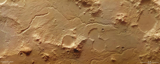
Libya Montes color image
• Fullscreen, Pan and Zoom • Download high resolution
The more longitudinal shaped valleys, like the one in the center of the image, were carved by flowing water and later modified by groundwater-induced processes. The pictured valley originates from an impact crater in the South, and discharges to the North. The course of the stream is characterized by abrupt changes in direction that indicate the influence of local topography and maybe tectonics. Evaluations of impact crater size-frequency distributions, a method in planetary sciences to estimate the age of a solid planetary surface, reveal that valley incision took place about 3.6 Ga ago.
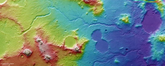
Libya Montes color coded digital terrain model
• Fullscreen, Pan and Zoom • Download high resolution
The mineralogy in the Libya Montes region is very diverse. Various aqueously-formed and chemically altered minerals testify past hydrothermal activity in context with the formation of the Isidis impact basin and fluvial activity. As a result, basaltic mountain material was altered to phyllosilicates which were detected from Mars orbit by spectrometer instruments.
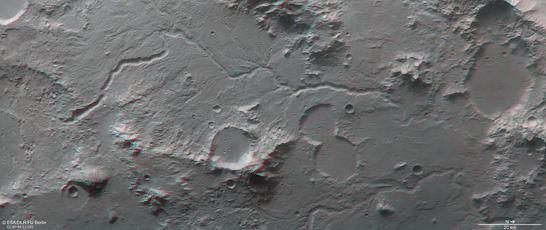
Libya Montes anaglyph
• Fullscreen, Pan and Zoom • Download high resolution
Image processing and the HRSC experiment on Mars Express
The images were acquired by the HRSC (High Resolution Stereo Camera) on 21 February 2017 during Mars Express Orbit 16647. The ground resolution is approximately 15 meters per pixel and the images are centered at 90° East and 1° North. The color image was created using data from the nadir channel, the field of view which is aligned perpendicular to the surface of Mars, and the color channels of the HRSC. The oblique perspective view was generated using data from the HRSC stereo channels. The anaglyph, which provides a three-dimensional view of the landscape when viewed using red-green or red-blue glasses, was derived from data acquired by the nadir channel and one stereo channel. The color-coded topographic view is based on a digital terrain model (DTM) of the region, from which the topography of the landscape can be derived. The reference body for the HRSC-DTM is a Mars sphere.
Mapserver
To download released raw images and DTMs of the region in GIS-ready formats, follow this link to the mapserver
Copyrights
Images: ESA/DLR/FU Berlin, CC BY-SA 3.0 IGO
Copyright Notice:
Where expressly stated, images are licenced under the Creative Commons Attribution-ShareAlike 3.0 IGO (CC BY-SA 3.0 IGO) licence. The user is allowed to reproduce, distribute, adapt, translate and publicly perform it, without explicit permission, provided that the content is accompanied by an acknowledgement that the source is credited as 'ESA/DLR/FU Berlin', a direct link to the licence text is provided and that it is clearly indicated if changes were made to the original content. Adaptation/translation/derivatives must be distributed under the same licence terms as this publication.
The High Resolution Stereo Camera was developed at the German Aerospace Center (DLR) and built in collaboration with partners in industry (EADS Astrium, Lewicki Microelectronic GmbH and Jena-Optronik GmbH). The science team, which is headed by Principal Investigator (PI) Ralf Jaumann, consists of 52 co-investigators from 34 institutions and 11 countries. The camera is operated by the DLR Institute of Planetary Research in Berlin-Adlershof.