Department of Earth Sciences
Service Navigation
Idaeus Fossae – Rare “Butterfly” Pattern spotted on Mars
Image data, taken by the High Resolution Stereo Camera (HRSC) on board ESA’s Mars Express mission shows a special type of crater in the Martian lowlands known as butterfly crater. HRSC is a camera experiment that was developed and is operated by the German Aerospace Center (Deutsches Zentrum für Luft- und Raumfahrt; DLR).
» read more in the main article below...

Idaeus Fossae • Position & 3D view

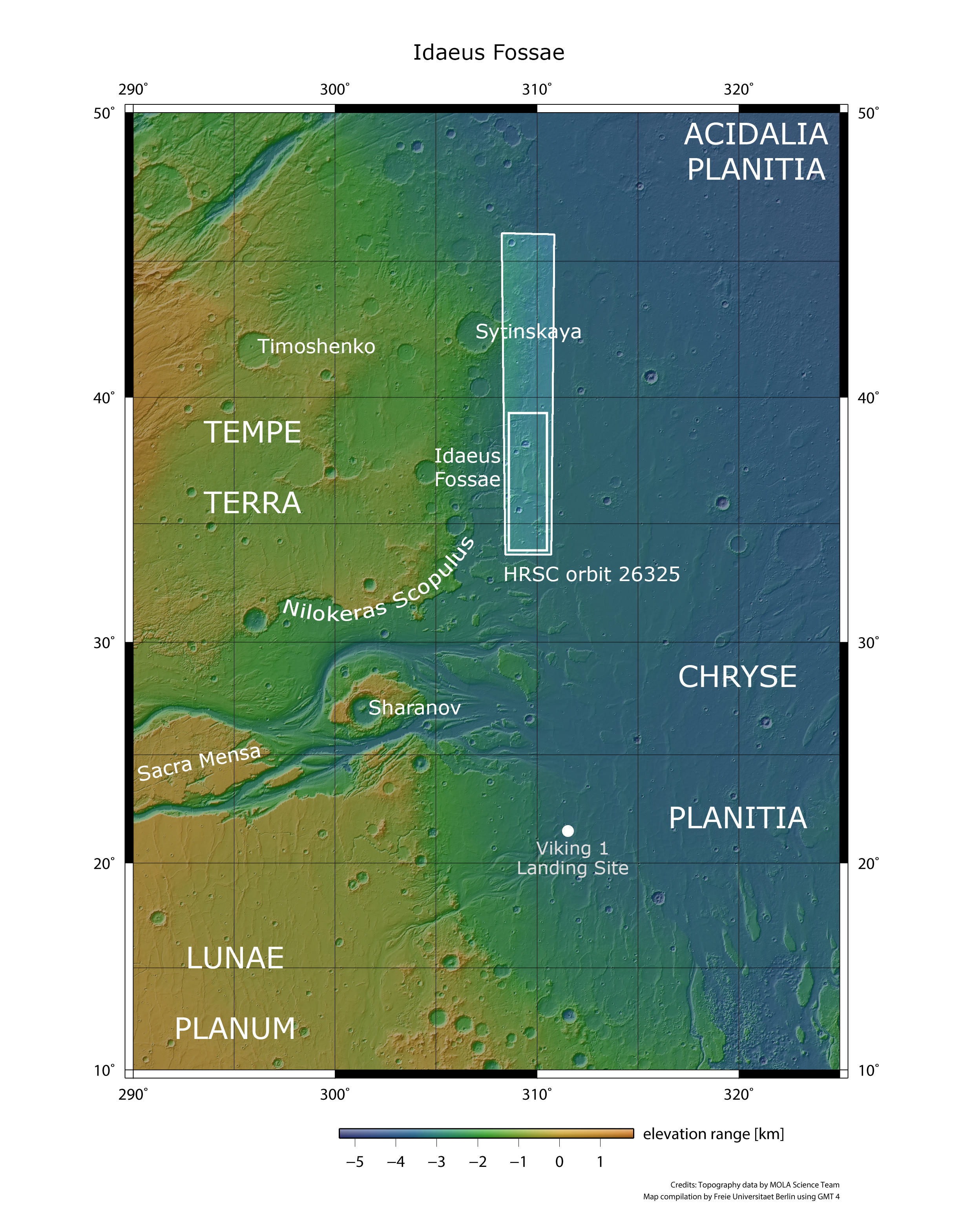
Idaeus Fossae - context map
Image Credit: MOLA Science Team/FU Berlin

Idaeus Fossae - 3D perspective 1
Image Credit: ESA/DLR/FU Berlin

Idaeus Fossae - 3D perspective 2
Image Credit: ESA/DLR/FU Berlin

Idaeus Fossae - 3D perspective 3
Image Credit: ESA/DLR/FU Berlin
Idaeus Fossae • HRSC images

Idaeus Fossae - HRSC color-coded terrain model
Image Credit: ESA/DLR/FU Berlin

Idaeus Fossae - HRSC color image
Image Credit: ESA/DLR/FU Berlin

Idaeus Fossae - HRSC annotated
Image Credit: ESA/DLR/FU Berlin

Idaeus Fossae - HRSC anaglyph
Image Credit: ESA/DLR/FU Berlin
Idaeus Fossae
The new HRSC image shows a region located in the northern hemisphere, along the Martian dichotomy boundary that separates the ancient highlands of Tempe Terra from the northern lowlands of Chryse Planitia and the southern Acidalia plains (see context map). Just a few kilometers to the southwest lies the outlet of Kasei Valles, one of Mars’ largest outflow channels, carved by catastrophic floods in the planet’s past (see context map). The dichotomy boundary here is marked by a steep escarpment known as Nilokeras Scopulus – from the Latin meaning scarp or cliff – which rises about two kilometers above the surrounding terrain (see context map). Standing at the edge of the Tempe Terra plateau would feel much like standing at the rim of the Grand Canyon – except that this Martian cliff stretches nearly twice the canyon’s length. The scarp likely formed through a combination of tectonic faulting and erosion caused by the flooding events that shaped Kasei Valles.
Also not far away, south of the mouth of Kasei Valles and the scene shown here (see context map), is the landing site of NASA's Viking 1 mission, the first probe to carry out experiments on the planet over a long period of time. The mission landed on 20 July 1976 in the west of the Chryse Planitia plain. The landing was originally planned for the American Independence Day on 4th of July 1976, but the Viking 1 orbiter showed a large density of boulders at the intended landing site in the first images from orbit, which posed a risk to the landing. NASA therefore spent ten days searching for a more suitable landing site. The caution and patience paid off: Viking 1 functioned until the end of 1982.
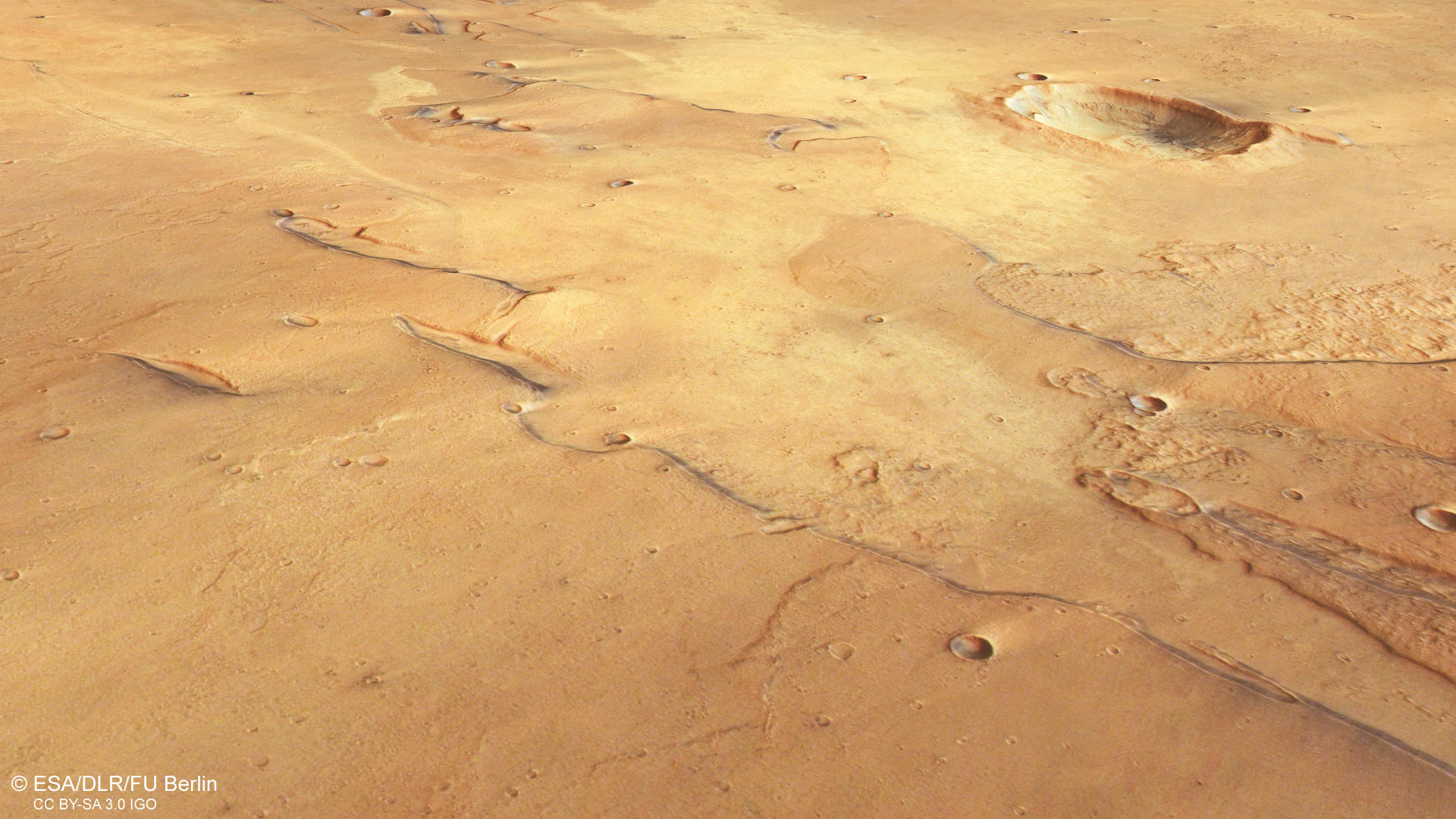
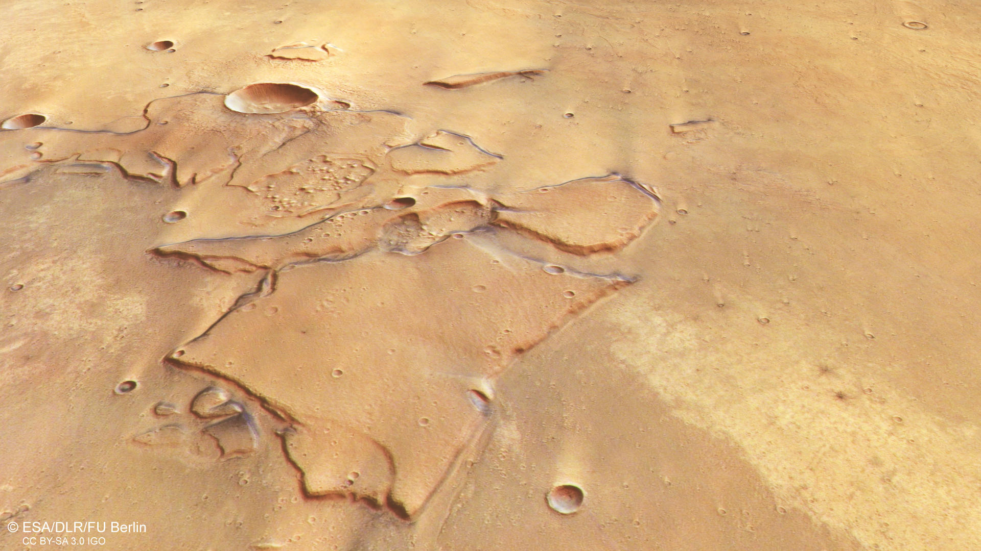
Within the HRSC image frame, mostly flat terrain dominates, with a few dark-layered mesas and an unusual-looking impact crater. The reddish-brown surface gradually darkens from south (left) to north (right), with several brighter patches scattered across the scene (see annotated image). Narrow, linear valleys also appear in places – they belong to a bigger geological structure known as Idaeus Fossae, a system of valleys just a few kilometers west of the image frame (see annotated image).
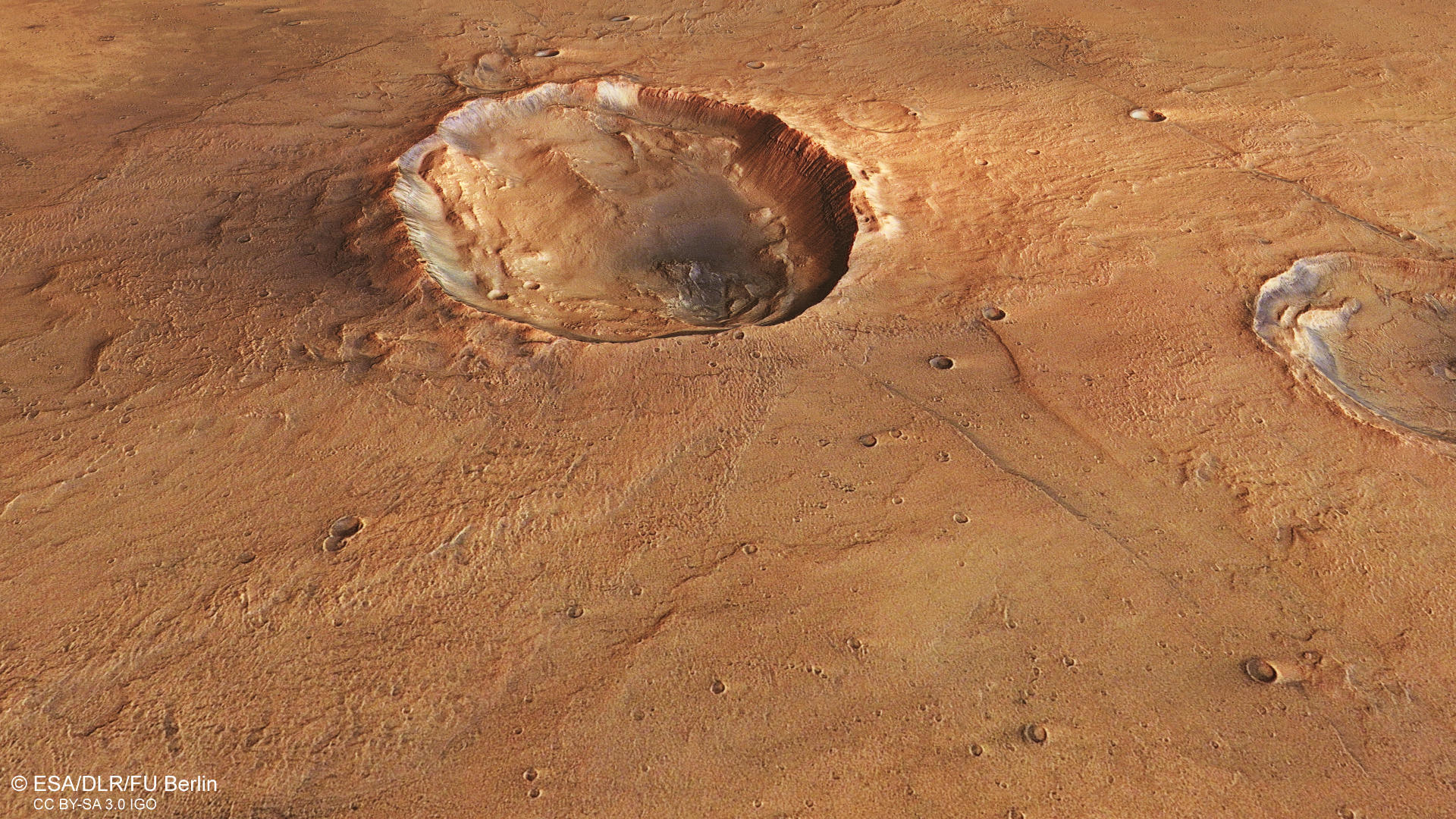
On the northern (right) side of the image, an elliptical impact crater draws attention, measuring roughly 20 kilometers from east to west and 15 kilometers from north to south (see annotated image). While most impact craters are relatively circular, the elliptical shape of this one suggests an oblique (low-angle) impact. Despite the non-circularity of the crater rim, the asymmetry shape of the ejecta blanket provides evidence of a shallow impact angle. It forms two prominent lobes of material extending north and south of the crater, but is notably absent to the east and west, where ejecta material would typically be expected (see annotated image). Due to their resemblance to the outspread wings of a butterfly, these craters are known as butterfly craters. The ejecta material also shows characteristics of fluidized material, which form when impact debris mixes with water or ice in the subsurface. Such ejecta often displays overlapping lobes and a distinct rounded boundary – a morphology also visible partly in the upper right of the image (see annotated image).
On the left side of the image, mesas – flat-topped hills – dominate the landscape (see annotated image). These rock outcrops are remnants of a once more extensive layer, which resisted the erosion. Against the reddish-brown Martian surface, their dark layering is standing out, which is even visible within the depressions like craters (see annotated image). Dark material on Mars, like on Earth, is composed of mafic mineral of volcanic origin. Zooming out to the surroundings, these dark layers are also prominent across Idaeus Fossae, indicating that they are a regional feature rather than a local deposit. The area likely experiences significant volcanic activity, with lava and ash deposits accumulating over time and subsequently buried by other material. Through these resistant mesas the dark-layering is exposed, offering a glimpse into Mars’ geological past. Evidence of the region’s volcanic past is also visible in the wrinkle ridges, particularly on the right side of the image (see annotated image). These features form when lava contracts as it cools, creating the characteristic folded, wrinkled patterns.
High Resolution Stereo Camera (HRSC)
The images were acquired by the HRSC (High Resolution Stereo Camera) on November 8, 2024 during Mars Express Orbits 26325. The ground resolution is approximately 17 meter per pixel and the image is centered at about 37° North and 309° East. The color image was created using data from the nadir channel, the field of view which is aligned perpendicular to the surface of Mars, and the color channels of the HRSC. The oblique perspective view was generated from the digital terrain model, the nadir and color channels of HRSC. The anaglyph image, which creates a three-dimensional impression of the landscape when viewed with red/blue or red/green glasses, was derived from the nadir channel and one stereo channel. The color-coded topographic view is based on a digital terrain model (DTM) of the region, from which the topography of the landscape can be derived.
HRSC is a camera experiment that was developed and is operated by the German Aerospace Center (Deutsches Zentrum für Luft- und Raumfahrt; DLR). The systematic processing of the camera data took place at the DLR Institute for Space Research in Berlin-Adlershof. The working group of Planetary Science and Remote Sensing at Freie Universität Berlin used the data to create the image products shown here.
To download released raw images and DTMs of the region in GIS-ready formats, follow this link to the mapserver
Images: ESA/DLR/FU Berlin, CC BY-SA 3.0 IGO
Copyright Notice:
Where expressly stated, images are licenced under the Creative Commons Attribution-ShareAlike 3.0 IGO (CC BY-SA 3.0 IGO) licence. The user is allowed to reproduce, distribute, adapt, translate and publicly perform it, without explicit permission, provided that the content is accompanied by an acknowledgement that the source is credited as 'ESA/DLR/FU Berlin', a direct link to the licence text is provided and that it is clearly indicated if changes were made to the original content. Adaptation / translation / derivatives must be distributed under the same licence terms as this publication.
The High Resolution Stereo Camera was developed at the German Aerospace Center (DLR) and built in collaboration with partners in industry (EADS Astrium, Lewicki Microelectronic GmbH and Jena-Optronik GmbH). The science team, which is headed by Principal Investigator (PI) Dr. Daniela Tirsch, consists of 50 co-investigators from 35 institutions and 11 countries. The camera is operated by the DLR Institute of Space Research in Berlin-Adlershof.