New paper: Satellite-observed flood indicators are related to riparian vegetation communities
Miriam Herrmann and Fabian Fassnacht published together with Ephraim Schmidt-Riese (TU Berlin), Daria Bäte (KIT), Fabian Kempfer (KIT), and Gregory Egger (KIT) a paper on describing fluvial disturbance using satellite images.
News from Aug 05, 2024
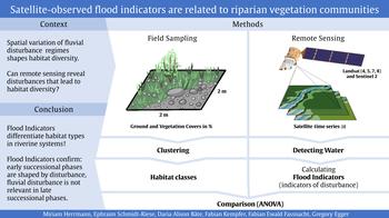
In riverine ecosystems, flood disturbances govern the distribution and assembly of vegetation communities. In the paper we present a novel approach to numerically characterize disturbance patterns in a spatially and temporally explicit way using semi-automated water detections in Sentinel-2 and Landsat data. Multitemporal metrics referred to as Flood Indicators are derived and compared to habitat classes formed by vegetation communities.
The observed relationship between vegetation communities and the satellite-derived disturbance measures underlines the potential of the presented approach to characterize riverine disturbance regimes. Given the global availability of satellite data, the approach should be easily transferable to other study areas.
Read the full article here: https://www.sciencedirect.com/science/article/pii/S1470160X24007702
Cite the atricle: Herrmann, M., Schmidt-Riese, E., Bäte, D. A., Kempfer, F., Fassnacht, F. E., & Egger, G. (2024). Satellite-observed flood indicators are related to riparian vegetation communities. Ecological Indicators, 166, 112313.
You have questions about the article? Please get in touch! https://www.geo.fu-berlin.de/en/geog/fachrichtungen/geoinformatik/mitarbeiter/mherrmann/index.html
