Land Use
Agricultural use
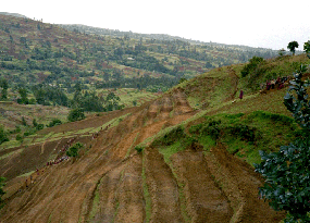
Rainfed agriculture predominates land use in nearly all morphological units of the Gina River catchment (highlands). In contrast, in the Rift Valley (lowlands) land is to a lower extent used for agriculture. Cultivation also mostly takes place in irrigated plantations. This distribution of land use between low- and highlands can be attributed to the different availability of water. The predominance of agriculture particularly in the Undulating areas can be explained by the relatively smooth relief and a soil texture appropriate for cultivation.
Pasture land
Land use is determined by pasture land in those areas unfavourable for agriculture (in Mountain tops due to high altitudes and hypsographic change; Shallow valley due to phreatic surface).
Woodland
The occurrence of woodlands as alluvial forests along the major draining courses indicate that they are possibly the contractive remnants of the former area-wide existing woodlands. Today they can be found at locations where access is difficult.
Settlements
The building of the central agglomeration Mesho at the fringe of the Plain and the Shallow valley results from the local relief: flat or slightly rolling areas providing favourable living conditions with permanent water supply. Also, relatively high density of tukuls can be referred to the relief characteristics of the Undulating areas, Plain and Shallow valley units. Opposite to this, only a few tukuls occur in areas disadvantageous for settling (in Steep and Deep valley due to strong slope inclination; in Mountain top areas due to uncomfortable weather conditions).
Thus, land use in the Gina River catchment correspondents in principal with the environmental conditions. However, even the disadvantageous areas are affected by human impact (e.g., agricultural activities in the Steep slope and Deep valley units; no forest and grassland remained on Mountain tops and Deep valley units). This dissemination of human activities is due to the high population pressure prevalent throughout Ethiopia (Beck et al. 2004).
Follow the discussion of the results of the investigation of soil conservation measures by clicking on this link.


