Soils
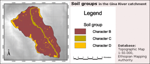
Soil texture differentiated after Curve Number-soil groups in the Gina River catchment
Image Credit: Adapted from Beck et al. 2004, 37
The soil survey focused on information about infiltration capacity because of its significance for soil erosion processes. The infiltration capacity is correlated to the soil texture that was analysed in the field (Richter 1998). Three categories were differentiated in the investigation which show following results (see figuren):
- clay loam exceeds (88 % of the soils of the Gina River catchment) the other two soil categories;
- clay (7 %) is located on the Mountain tops and on plots with eroded soil;
- sandy loam occurs (5 %) only along the Gina River course (Beck et al. 2004, 35).
A high amount of sediments with sediment layers of several meters thickness occur with sharp boundaries to saprolite or C-horizons.
See how the land and these soils are used on the following page.

