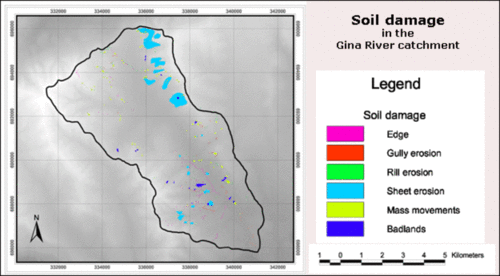
Soil erosion damages
Distribution of soil erosion damages in the Gina River catchment
Image Credit: Adapted from Beck et al. 2004
Soil erosion damages occur all over the Gina River catchment (see figure).
Relation between soil erosion damages and morphological units
Soil erosion damages are closely related to the defined morphological units.
Most damages are recorded in the Steep slopes and Undulating areas. In contrast, only little soil erosion damages occurs on the Mountain tops and along the Shallow valleys.
The distribution of soil erosion types in the individual morphological units
Rill erosion, talus edges, mass movements and badlands occur all over the Gina River catchment with only few exceptions and to different extents. Sheet erosion was particularly detected in the Undulating areas and Steep slopes in the north (Beck et al. 2004, 40-43). To see the distribution of soil erosion types in the individual morphological units in detail click on this link.
The relation of soil erosion damages to slope inclination and to land use practiced is shown if you follow this hyperlink.
You can see the results of the rainfall-runoff-modelling by clicking on this hyperlink.

