Department of Earth Sciences
Service Navigation
JANUS onboard JUICE - Support for Operational Activities

Overview of JUICE's Journey to Jupiter
Image Credit: ESA

Artistic conception of the JUICE spacecraft approaching Ganymede
Image Credit: ESA
The Jupiter Icy Moons Explorer (JUICE) is a flagship space mission led by the European Space Agency (ESA), launched on 14 April 2023. Its primary goal is to explore Jupiter and its three largest ocean-bearing moons – Ganymede, Europa, and Callisto – with emphasis on investigating their icy shells, subsurface oceans, surface geology, and potential habitability. JUICE will arrive at Jupiter in July 2031 and conduct at least four years of scientific observations, including detailed orbiting of Ganymede.
Among JUICE’s scientific instrumentation is the JANUS camera (Jovis, Amorum ac Natorum Undique Scrutator), a high-resolution imager that captures detailed surface features of Jupiter’s moons. JANUS acquires multispectral context images of the surfaces of Ganymede and Callisto, enabling the identification and mapping of color variations related to surface composition with spatial resolutions unmatched by other JUICE instruments. Additionally, JANUS targets selected regions at the highest spatial resolution to study physical surface properties in detail. The project aims at supporting the operational activities of JANUS and is divided in three sub-projects:
- Cryovolcanic Processes and Topographic Modeling
- Software Development for Observation
- SimulationImage Database Development
1. Cryovolcanic Processes and Topographic Modeling
During the Voyager and Galileo missions, isolated regions on Ganymede’s surface exhibited signs of possible cryovolcanic activity, characterized by "scalloped depressions" or "paterae" resembling calderas. However, limited spatial resolution prevented acquisition of detailed data on their topography, age, and surface composition, restricting definitive identification of cryovolcanism or its implications regarding Ganymede’s subsurface ocean and habitability. More recently, JunoCam aboard NASA’s Juno spacecraft has identified numerous new paterae on Ganymede, enhancing the data pool and enabling improved planning for future observations.Recent studies have revealed compelling evidence for shallow liquid pockets within Europa’s ice shell, with surface fracture patterns indicating tectonic and possible cryovolcanic influences.
Possible cryovolcanic activity has not been observed at sufficient spatial resolution to characterize features on Ganymede fully. As a result, critical information about local topography, surface age, and composition remains lacking. The generation of digital elevation models (DEMs) from existing data sets is essential for optimizing and guiding forthcoming JANUS observations. In the absence of stereo images, 3D models are derived using single-image methods like photoclinometry.
Key Tasks:
-
Create elevation models and image mosaics of Ganymede and Europa from historical mission data
-
Analyze image data for signs of cryovolcanic activity and shallow liquid pockets
-
Compare geological observations between Ganymede and Europa
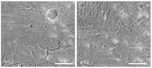
Paterae on Ganymede
2. Software Development for Observation Simulation
Efficient observational planning depends on simulating image acquisition under specific lighting conditions to determine optimal exposure times.
This simulation requires a quantitative understanding of three components:
- Camera light sensitivity, calibrated across wavelengths considering optical elements.
-
The light source spectrum, usually the Sun; in some cases, reflected light from bright host planets also contributes. Temporal variations in sunlight are accounted for in calibration.
-
The reflection spectrum of the target surface.
Integrating these factors enables estimation of expected signal and signal-to-noise ratio (SNR). The JANUS experiment specifies required SNR levels to guide exposure durations.
Key Tasks:
-
Developing software subtasks that model these components
-
Perform signal calculations for observation planning
3. Image Database Development
Starting in 2026, development of an image database will commence, beginning with the creation of a metadata catalog for JANUS camera data, adhering primarily to the PDS4 archive standard. Existing database projects will be reviewed and integrated into this new architecture. JANUS test data sets will be included for operational testing and validation.
Key Tasks:
-
Construct a relational database linked with geometric data
-
Define database schemas based on JANUS metadata requirements
-
Design and build a database backend and public middleware to connect with the JANUS team
PARTICIPANTS IN THIS PROJECT:
GRANT DETAILS:
BMWK - 50QJ2404