Department of Earth Sciences
Service Navigation
The Medusae Fossae Formation at Eumenides Dorsum – wind at work -
Image data by the High Resolution Stereo Camera (HRSC) on board ESA’s Mars Express mission show intense wind erosion sculptuing the landscape at Eumenides Dorsum. The High Resolution Stereo Camera (HRSC) is a camera experiment that was developed and is operated by the German Aerospace Center (Deutsches Zentrum für Luft- und Raumfahrt; DLR).
» read more in the main article and below the gallery about the Medusae Fossae Formation ...
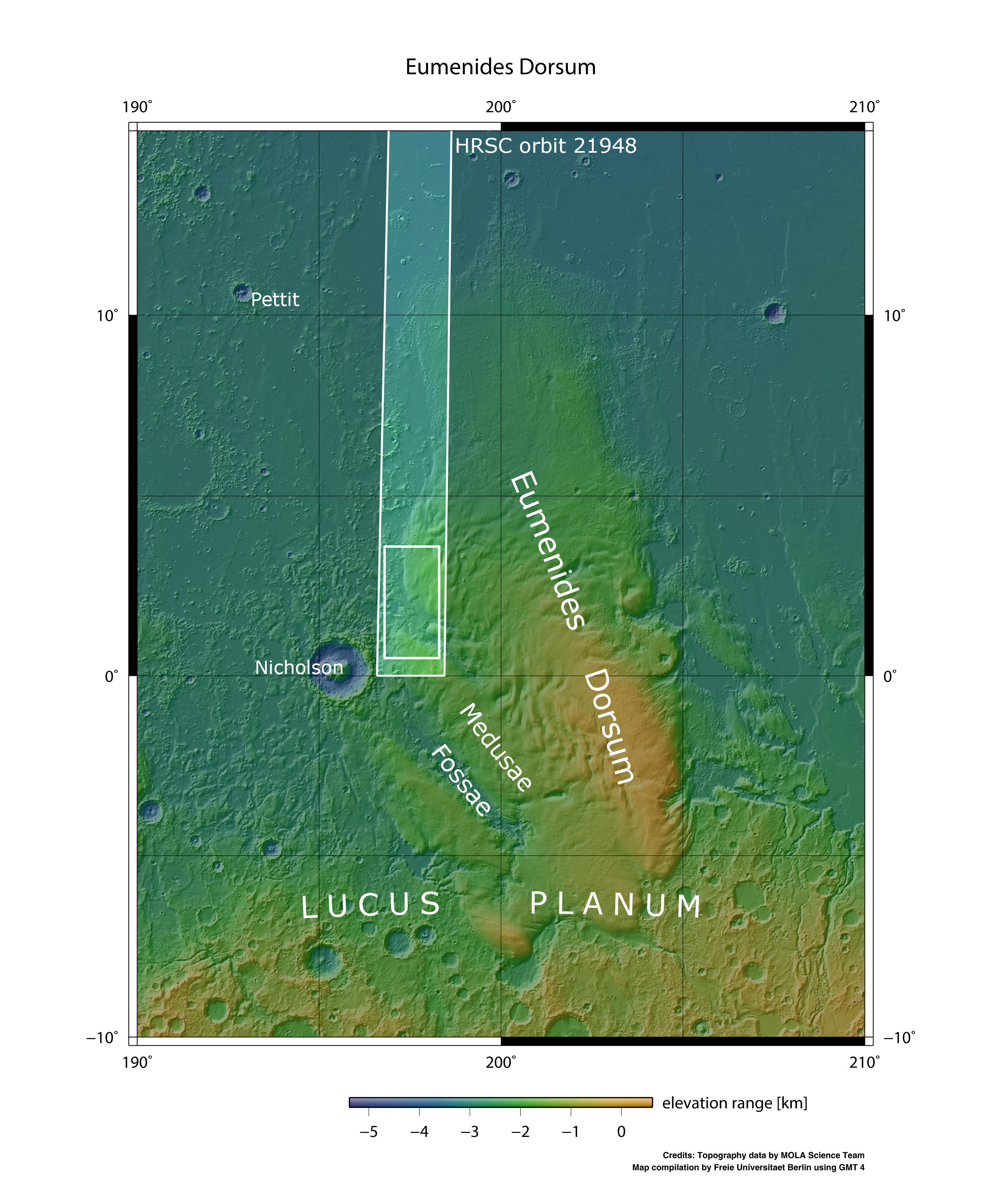
Medusae Fossae • Position & 3D view

Medusae Fossae map
Image Credit: MOLA Science Team/FU Berlin

Medusae Fossae 3D
Image Credit: ESA/DLR/FU-Berlin

Medusae Fossae 3D_2
Medusae Fossae HRSC images

Medusae Fossae color image
Image Credit: ESA/DLR/FU-Berlin

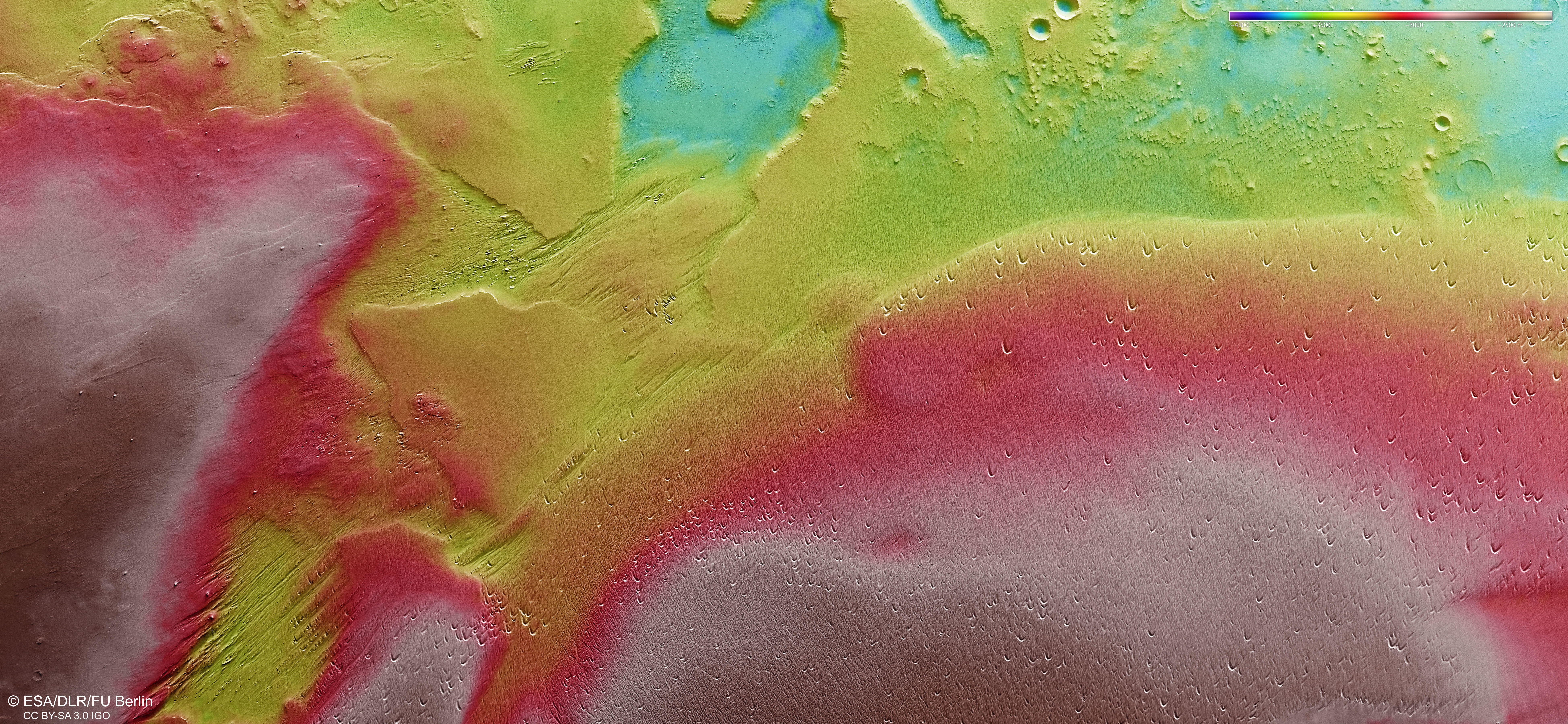
Medusea Fossae color-coded terrain model
Image Credit: ESA/DLR/FU-Berlin

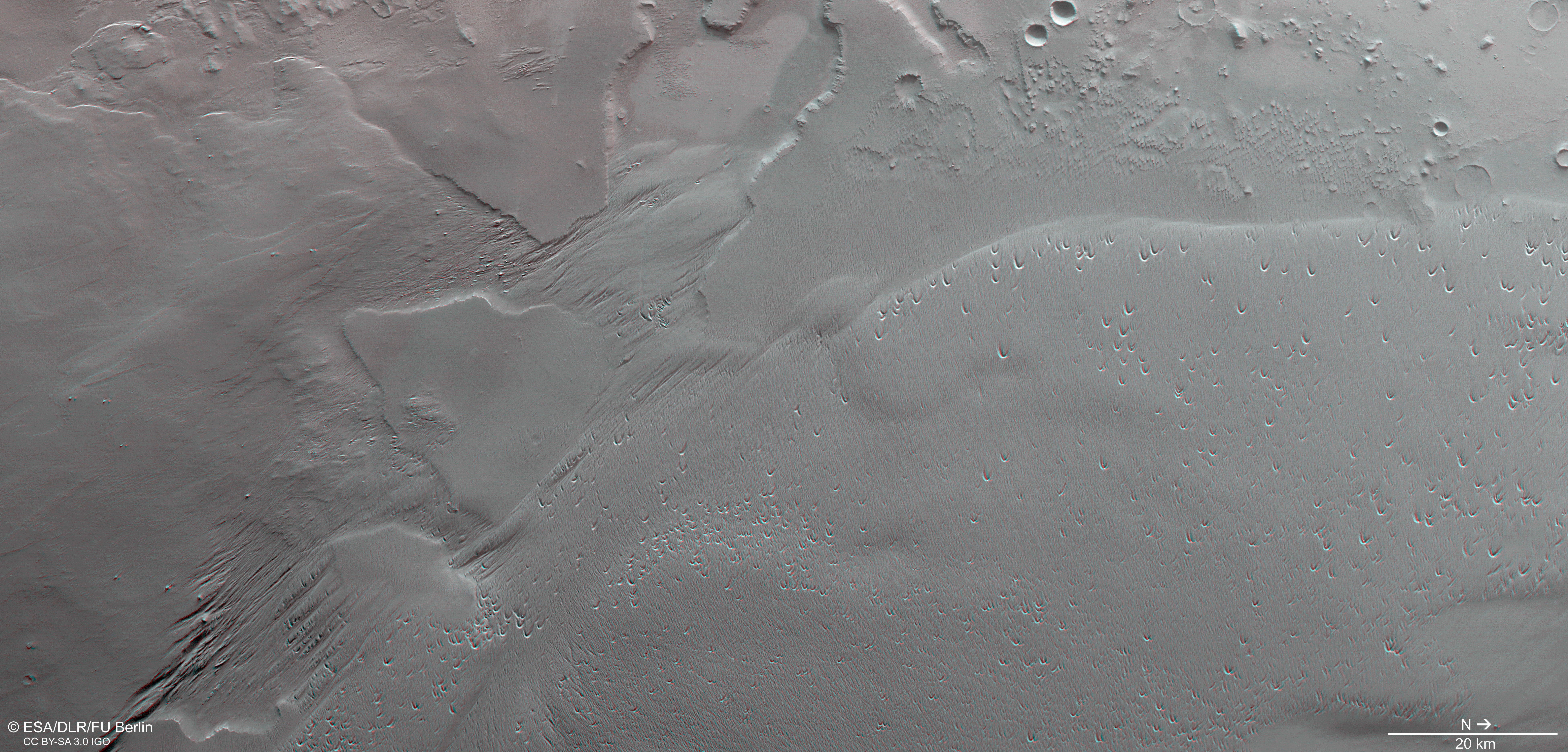
Medusae Fossae anaglyph
Image Credit: ESA/DLR/Fu-Berlin
The Medusae Fossae Formation at Eumenides Dorsum – wind at work -
» read more about the Medusae Fossae formation
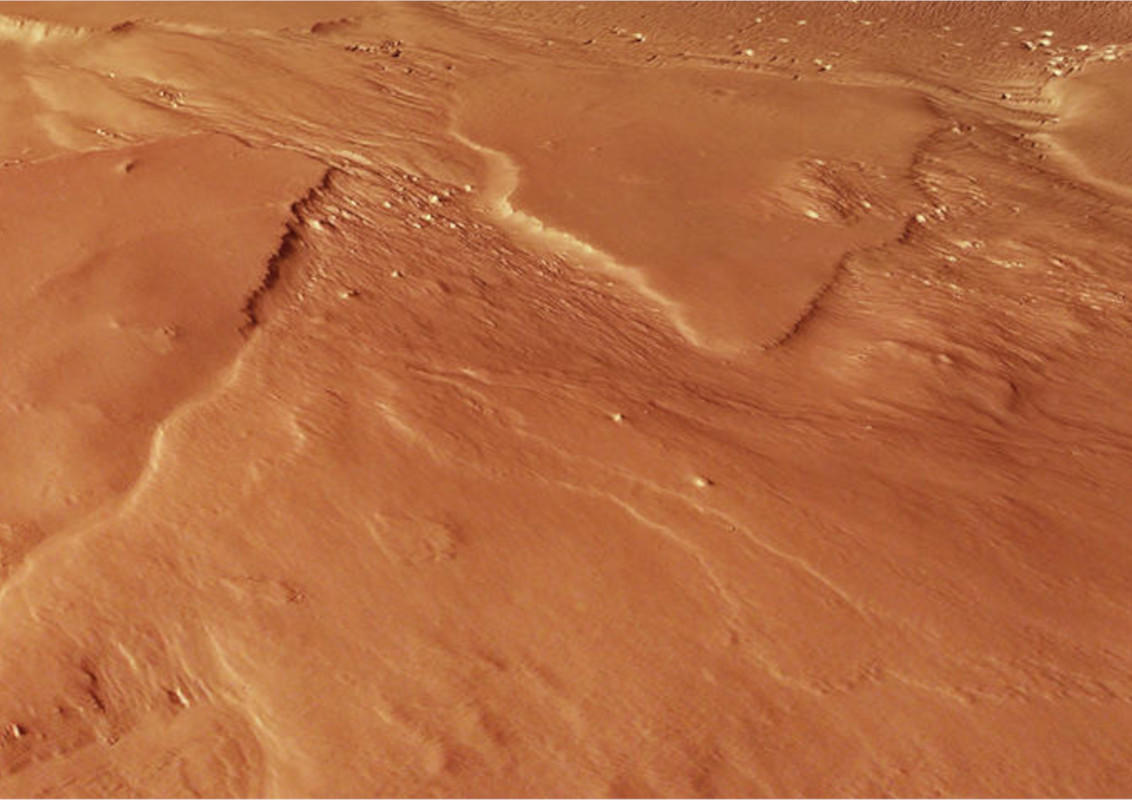
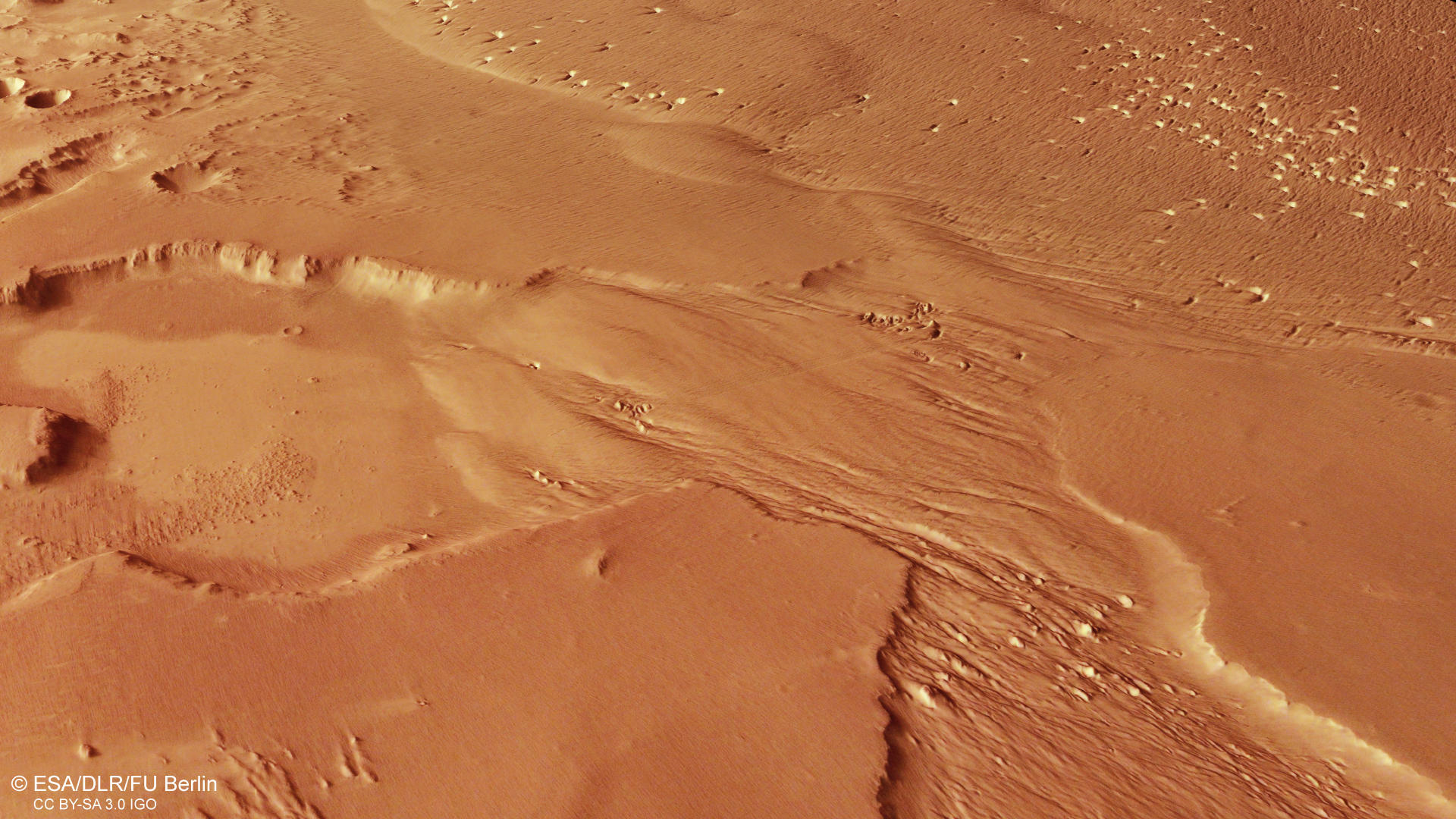
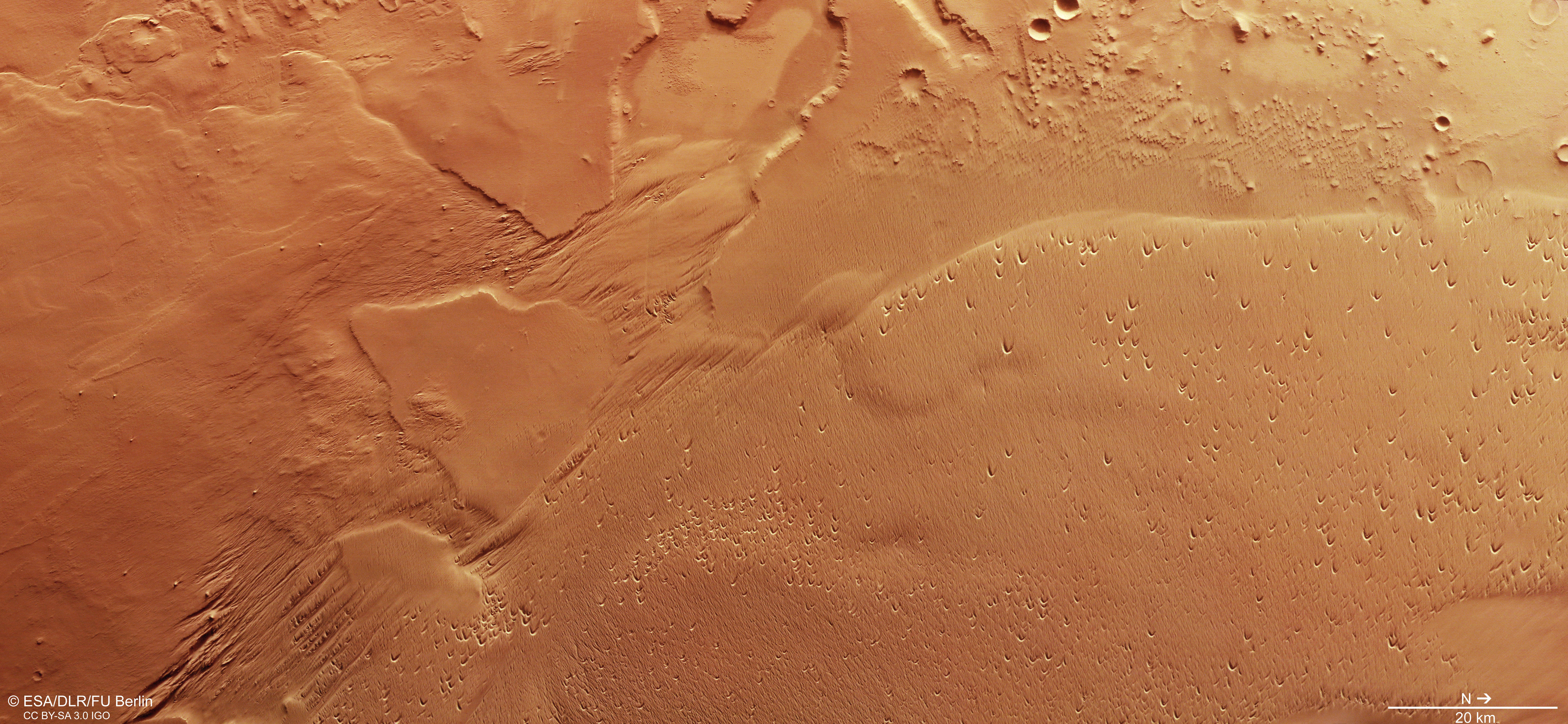
The Eumenides Dorsum mountain range is located west of the Tharsis region and is part of the Medusae Fossae Formation (MFF). The MFF itself is a very extensive geological formation found along the Martian highland-lowland boundary between the Tharsis and Elysium volcanic centers. The formation appears easily erodible and extends discontinuously for more than 5000 km, covering a region about the size of India.
It is thought, that the MFF consists of ash that was deposited by pyroclastic flows or volcanic air falls from the Tharsis volcanos or from Olympus Mons starting in Hesperian times, some 3.8-3.0 billion years ago. In general, the surface of the formation appears smooth and gently undulating as seen in the upper left portion of the image (southwest). Other regions are wind-sculptured into kilometer long linear ridges and grooves like in the center and lower left part of the image (southeast). The ridges are called yardangs and generally point in direction of the prevailing winds that carved them.
Many crescent shaped depressions can be spotted all over the low right part of the image. These hollows are apparently carved into the sand by wind and are called blowouts. A blowout is a saucer or trough-shaped depression created by wind erosion on a preexisting sand deposit and formed together with an adjoining sand accumulation called depositional lobe or blowout dune. The process of creating the blowout is rather simple: The wind transports the sand and erodes the smooth surface. When it hits a buried object, like for example a rock or just a more resistant portion of the sediment, the wind with the sand is forced around the object, creating an eddy at the face of the object. The wind is then forced downward, around and then up, carving out a hollow while lifting the sand from the base of the obstacle and depositing it behind it.
Only very few craters can be found on the surface. This indicates that that wind erosion has been the latest stage of erosional processes acting here. In the upper right part of the image, some few impact craters are visible, possibly showing the underlying older rocks that were draped by the MFF. The MFF is believed to be the largest sedimentary deposits on the planet and also the largest single dust source on Mars.
High Resolution Stereo Camera (HRSC)
» information to image origin and processing
The images were acquired by the HRSC (High Resolution Stereo Camera) on 14 May 2021 and 2 June 2021 during Mars Express Orbit 21948. The ground resolution is approximately 19 meters per pixel and the images are centered at about 192° East and 2° North. The color image was created using data from the nadir channel, the field of view which is aligned perpendicular to the surface of Mars, and the color channels of the HRSC. The anaglyph image, which creates a three-dimensional impression of the landscape when viewed with red/blue or red/green glasses, was derived from the nadir channel and one stereo channel. The oblique perspective view was generated from the digital terrain model, the nadir and color channels of HRSC. The color-coded topographic view is based on a digital terrain model (DTM) of the region, from which the topography of the landscape can be derived. The reference body for the HRSC-DTM is a Mars equipotential surface (Areoid).
HRSC is a camera experiment that was developed and is operated by the German Aerospace Center (Deutsches Zentrum für Luft- und Raumfahrt; DLR).The systematic processing of the camera data took place at the DLR Institute for Planetary Research in Berlin-Adlershof. The working group of Planetary Science and Remote Sensing at Freie Universität Berlin used the data to create the image products shown here.
To download released raw images and DTMs of the region in GIS-ready formats, follow this link to the mapserver.
Images: ESA/DLR/FU Berlin, CC BY-SA 3.0 IGO
Copyright Notice:
Where expressly stated, images are licenced under the Creative Commons Attribution-ShareAlike 3.0 IGO (CC BY-SA 3.0 IGO) licence. The user is allowed to reproduce, distribute, adapt, translate and publicly perform it, without explicit permission, provided that the content is accompanied by an acknowledgement that the source is credited as 'ESA/DLR/FU Berlin', a direct link to the licence text is provided and that it is clearly indicated if changes were made to the original content. Adaptation / translation / derivatives must be distributed under the same licence terms as this publication.
The High Resolution Stereo Camera was developed at the German Aerospace Center (DLR) and built in collaboration with partners in industry (EADS Astrium, Lewicki Microelectronic GmbH and Jena-Optronik GmbH). The science team, which is headed by Principal Investigator (PI) Dr. Thomas Roatsch, consists of 52 co-investigators from 34 institutions and 11 countries. The camera is operated by the DLR Institute of Planetary Research in Berlin-Adlershof.