The landing of Perseverance - NASA's Mars Rover
The NASA Mars 2020 mission is en route to Mars since July 30th 2020. On board: The NASA rover “Perseverance”, the most complex equipment ever sent to Mars. Besides numerous scientific instruments, it will carry containers for a drill core sample collection that will be left on Mars for a later return to Earth carried out by follow-up missions planned for the 2030s. The approximately one metric ton heavy vehicle is set to land on 18 February 2021 at 21:55 CET in Jezero crater and will then start the search for traces of microbial life. The research group of Freie Universität Berlin, with Prof. Dr. Ralf Jaumann as co-investigator in the Mastcam-Z (Mast Camera, Zoom) stereo camera on "Perseverance". The camera will be able to provide 360-degree panoramas in 3D and in colour. In total, the rover has 23 cameras, more than any other interplanetary mission to date.Also on board the rover "Ingenuity", a 1.8 kg helicopter drone that will be used as a near-field reconnaissance instrument.
See also link: Flight over Jezero Crater - NASA Mars 2020 Landing Site from 29.07.2020
General about Jezero Crater and Landing Site
HRSC’s high-resolution digital terrain models have made important contributions to the selection of numerous landing sites on Mars, including that of the Mars 2020 mission. Accurate topographical information is critical for ensuring a safe landing (see also PR Mars 2020 landing site close-up from 16.02.2021).
The latest map sheets, each covering an area of over three million square kilometres, can be downloaded from the website of the HRSC team from the map server of the Freie Universität Berlin and at DLR. One of these map sheets (MC-13 East) was used for the image products shown here. This section depicts the wider geographical context around the landing site, located at approximately 18 degrees north and 77 degrees east. The area shown is more than 1.5 million square kilometres (1330 by 1195 kilometres – over twice the size of the Iberian Peninsula) and gives a good overview of the location of the impact crater and the geological context. However, the maps shown here not only provide a large-scale overview of the geographic location, they also provide an outstanding view of details that is exceptional for such large-scale images. The high resolution of these image here allows them to be greatly enlarged for a closer look at individual details of the landscape.
The extraordinary geological diversity of this region helped Jezero Crater finally come out on top after the intensive, meticulous selection of the landing site, which took five years. The crater lies exactly on the border between the ancient highland region of Terra Sabaea, where rocks from the Martian Palaeozoic (the Noachian: 4.1–3.7 billion years ago) can still be found, and the similarly ancient Isidis impact basin, which was formed 3.9 billion years ago. However, its present-day Isidis Planitia plain was formed primarily by much younger deposits formed in the Martian Middle Ages, the Hesperian (3.7–3.0 billion years ago) and the Martian Modern (the Amazonian 3.0 billion years to present day). The nearby Nili Fossae graben system, which roughly traces the shape of the rim of the Isidis basin through its curvature, was formed precisely by this impact as a result of tectonic fractures. To the southwest of Jezero Crater is the volcanic region of Syrtis Major, whose most recent lava flows are also assigned to the Hesperian. Thus, the rocks and deposits in and around the crater originate from all three geological epochs of Mars.
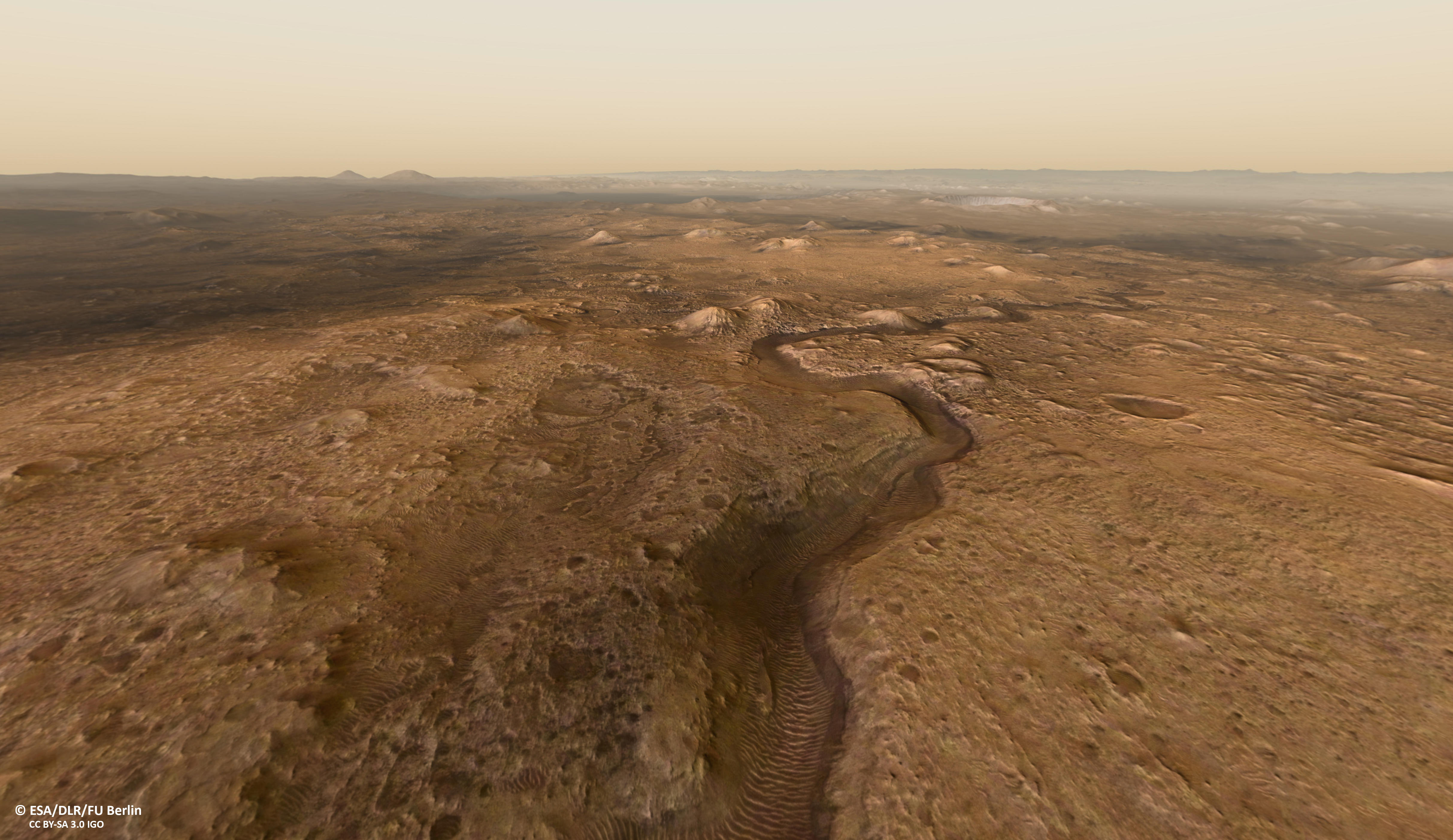
View into the outflow valley and the delta areas
The outflow channel Pliva Vallis (Viewpoint Outflow channel) breaks through the eastern crater rim surpassing a swell. Using altitude measurements from crater rim, crater floor, swell and upper edge of the delta, the potential depth of the lake can be deduced, resulting in roughly 250 m water depth. This would result in a minimum lake water volume of 220 km3 and a maximum of 340 (see corresponding images). However, as the deltas have been severely eroded since water activity ceased approximately 3.8 billion years ago, it is no longer possible to make precise assessments. Also, the crater was filled with very extensive lava flows from the nearby Syrtis Major volcanic region about 300 million years later.
Jezero crater was chosen for a good reason as landing site. Two ancient river deltas can be found inside the crater. Within the delta deposits, numerous water-bearing minerals have been found, indicating, that liquid water was once present for an extended period of time.
Two inlet valleys, Neretva Vallis and Sava Vallis can be spotted, entering the crater in the northern and northeastern part (Viewpoint Inlet 1) and ending in the deltas (Viewpoint Delta basement and Delta top). Here, water-bearing clay minerals and particularly carbonates were discovered. These minerals have a high potential of conserving and retaining biosignatures over long time spans. The former presence of liquid water and the large carbonate deposits here make Jezero a perfect destination for the search for possible traces of presumabely extinct life on Mars.
View from the mountain in southeast
The Mountain View viewpoint offers a perfect vista into the crater. This viewpoint is located on top of the large hill southeast of the crater. From here, the observer can see that the northern part of the crater floor is sloping and that the northern crater rim is clearly less defined, compared to the flat, smooth crater floor in the south and the much steeper southern crater rim flanks. This appearance originates from the erosion of material in the catchment areas to the north of the crater, which was then transported into the crater basin itself and deposited in the deltas. Also contributing to the asymmetrical topography is the erosion of the northern crater rim, caused by the river valleys breaking through the flank of Jezero.