Department of Earth Sciences
Service Navigation
The Nereidum Montes - Mountain range on Mars show off
Image data by the High Resolution Stereo Camera (HRSC) on board ESA’s Mars Express mission show the plethora of different landforms sculpted by wind, water, ice and tectonic forces in the Nereidum Montes region. HRSC is a camera experiment that was developed and is operated by the German Aerospace Center (Deutsches Zentrum für Luft- und Raumfahrt; DLR).
» read more in the main article and below the galleryabout the region Nereidum Montes...
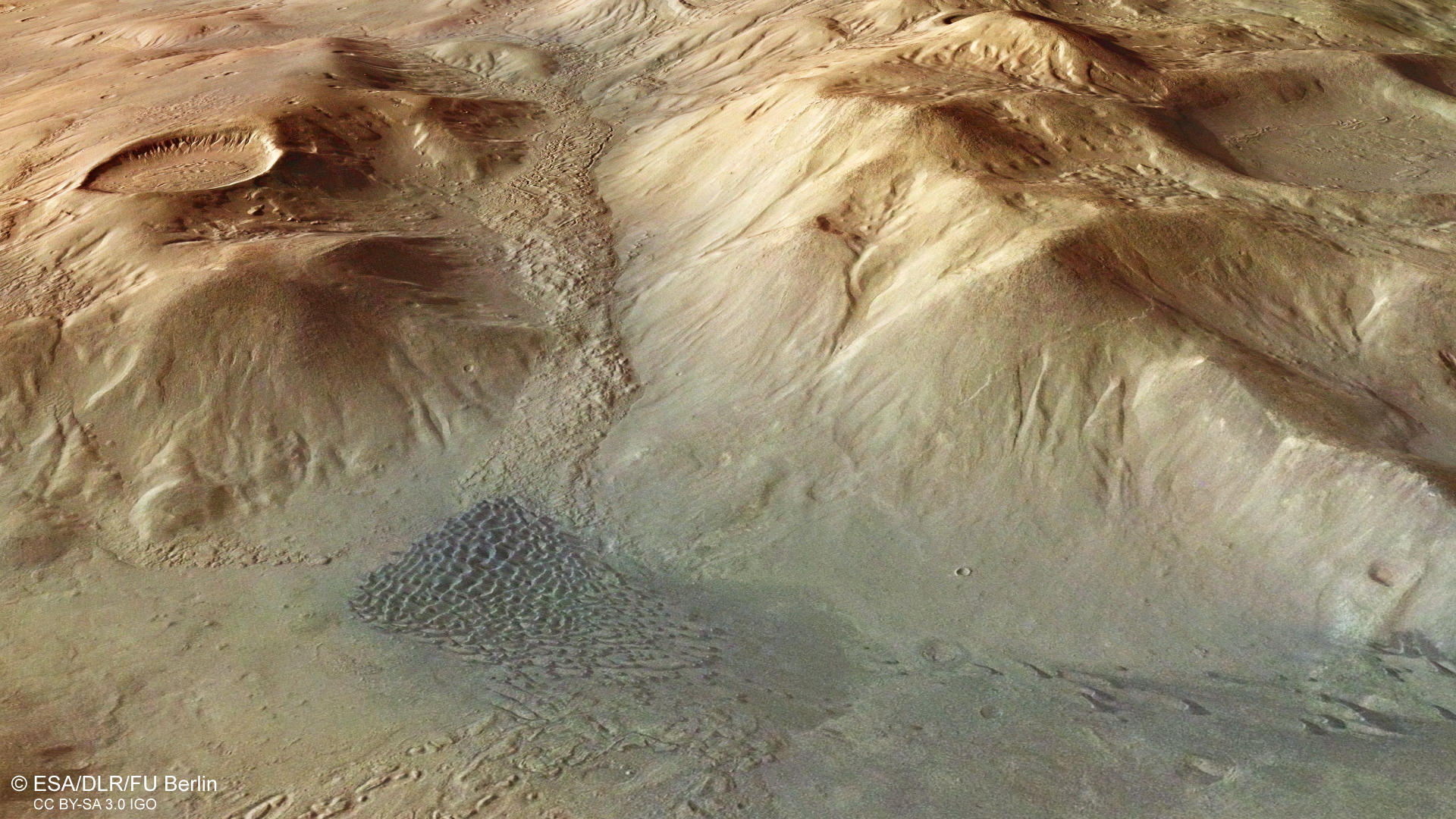
Nereidum Montes • Location and Structures

Geomorphology in Nereidum Montes
Image Credit: ESA/DLR/FU Berlin

Nereidum Montes Context map
Image Credit: MOLA Science Team/FU Berlin
Nereidum Montes • Images

Nereidum Montes Color image
Image Credit: ESA/DLR/FU Berlin

Nereidum Montes HRSC color-coded terrain model
Image Credit: ESA/DLR/FU Berlin

Nereidum Montes HRSC anaglyph
Image Credit: ESA/DLR/FU Berlin
Mountain landscape formed by water, wind and ice
» read more about the Nereidum Montes region on Mars
The Nereidum Montes are part of the northern rim of the Argyre Planitia basin. With a diameter of 1800 kilometers and a depth of up to five kilometers, Argyre is the second largest impact basin on Mars (the largest is Hellas Planitia). Similar to the Alps on Earth, the mountain range of the Nereidum Montes extends in an elongated arc over 1100 kilometers parallel to the basin rim. Individual mountain massifs are, as in Europe's high mountains, up to four thousand meters high.
However, the process of formation of the terrestrial Alps has taken a completely different course than that of the ring mountains of the Nereidum Montes on Mars. The latter are originally the result of an extremely large asteroid impact. The impact was so enormous that it not only created a bowl-shaped basin several kilometers deep, but also several concentric mountain rings at the edges, which are terraced by tectonic landslides of entire blocks of land. The European Alps, on the other hand, were pushed up to a folded mountain range of almost 5000 meters height by the collision of the African continental plate with the Eurasian plate. Incidentally, it is still growing today by about one centimeter per year, but at the same time it is being eroded again.
When Mars was not yet being examined by space probes at close range, even the most powerful telescopes from Earth could only detect large landscapes. This included the Argyre Basin, whose topography could not be derived from the telescopic observations. Named after two mythical islands, namely Chryse and Argyre, which Pliny the Elder (23-79 AD) located in the Indian Ocean near the mouth of the Indus River and to which large deposits of gold (gr. chrysos) and silver (argyros) were attributed, these names were incorporated into the first cartographic works on Mars.
Above all, Giovanni Schiaparelli (1835-1910) rendered outstanding services to the first detailed mapping of Mars, who used the proximity of Mars to Earth for intensive observations in 1877. At that time the "Golden Plain", Chryse Planitia, further north, was also included in the nomenclature. The Nereides Montes, the "Mountains of the Nereids" (named after the 50 daughters of Nereus, a sea god in Greek mythology, and his wife Doris, the daughter of Oceanos and the Tethys) did not receive their name until the space age, when smaller regional structures could also be identified.
The HRSC images show a region shaped by various geological processes after the formation of the Argyre ring basin about four billion years ago, where water, ice (on and below the surface) and more recently wind have left their traces of erosion. Originally, Argyre was much deeper than it is today. Eroded rock was transported by glaciers and flowing waters into the basin and gradually filled it up.
A striking network of small, ramified valleys in the right half of the picture (color image) testifies to water that has flowed from the edge of Argyres over the surface into the interior of the basin. It came either from rainfalls in the early days of Mars or from melted glacier ice. These drainage networks still document the water-rich past of Mars today.
For a long time, there has been intense debate about whether there was actually a significantly warmer and humid climate in the early Martian period that enabled a water cycle, even with precipitation and a network of water bodies on the surface, over a longer period of time - or only episodically. It is also conceivable that the thin atmosphere with hardly any greenhouse effect allowed only low temperatures, which rather led to ice-age processes with at best the precipitation of snow and associated glacial phenomena. Volcanic activity or regional asteroid impacts could then have sporadically caused dew processes that melted the ice on the surface and in the subsurface and mobilized flowing water in this way.
The latest findings prove that the numerous dried out river valleys on Mars were formed by at least four different drainage processes: Surface runoff due to precipitation, melting glaciers, subglacial runoff below glacial packs and outflowing groundwater (which in turn may have been formed by melting ground ice). The Nereidum Montes is a "key area" where these hypotheses can be well tested. Due to its morphology, the most likely origin of glacial ice is the melting of glacial ice.
Most impact craters in this area are filled with a material that shows a striking concentric pattern on the surface. Such structures indicate glaciers covered by rock debris, so-called block glaciers. In the valleys between the mountain ranges, these forms can also be recognized as extensive deposits. It is assumed that these landscape forms still hide water ice at greater depths under a layer of debris that prevents sublimation, i.e. the evaporation of the ice at the low gas pressure of the Martian atmosphere.
Last but not least, dark dune fields in the left half of the picture (color image) testify to the power of the wind and its ability to transport grains of sand over long distances and around obstacles. The grayish-blackish dune sands, which are very common on Mars, are of volcanic origin. This means that they consist mainly of old, temporarily buried volcanic ash, which was often brought to the surface by impacts from the Martian subsurface. In addition, these sands often contain fragments of crushed lava rock and volcanic glass. All these materials consist of dark, volcanically formed minerals, which were not converted to lighter minerals by the temporary covering in the Martian underground as elsewhere by water, which explains the blackish color of the dune sands.
The types of dunes also make it easy to determine the direction of the wind that has shaped the dunes: In this example you can clearly see isolated sickle dunes (so-called barchane), which have grown together at the end of the valley to form a barchanoidal dune field. In this case, the wind came from the southeast (bottom left of the picture color image), blew into the valley, drove the sands in front of it and deposited most of the material at the foot of the mountains.
High Resolution Stereo Camera (HRSC)
» information to image origin and processing
The images were acquired by the HRSC (High Resolution Stereo Camera) on 7 August 2015 during Mars Express Orbit 14709. The ground resolution is approximately 15 meters per pixel and the images are centered at about 312° East and 39,5° South. The color image was created using data from the nadir channel, the field of view which is aligned perpendicular to the surface of Mars, and the color channels of the HRSC. The oblique perspective view was generated from the digital terrain model, the nadir and color channels of HRSC. The anaglyph, which provides a three-dimensional view of the landscape when viewed using red-green or red-blue glasses, was derived from data acquired by the nadir channel and the stereo channels. The color-coded topographic view is based on a digital terrain model (DTM) of the region, from which the topography of the landscape can be derived. The reference body for the HRSC-DTM is a Mars equipotential surface (Areoid).
HRSC is a camera experiment that was developed and is operated by the German Aerospace Center (Deutsches Zentrum für Luft- und Raumfahrt; DLR).The systematic processing of the camera data took place at the DLR Institute for Planetary Research in Berlin-Adlershof. The working group of Planetary Science and Remote Sensing at Freie Universität Berlin used the data to create the image products shown here.
To download released raw images and DTMs of the region in GIS-ready formats, follow this link to the mapserver.
Images: ESA/DLR/FU Berlin, CC BY-SA 3.0 IGO
Copyright Notice:
Where expressly stated, images are licenced under the Creative Commons Attribution-ShareAlike 3.0 IGO (CC BY-SA 3.0 IGO) licence. The user is allowed to reproduce, distribute, adapt, translate and publicly perform it, without explicit permission, provided that the content is accompanied by an acknowledgement that the source is credited as 'ESA/DLR/FU Berlin', a direct link to the licence text is provided and that it is clearly indicated if changes were made to the original content. Adaptation / translation / derivatives must be distributed under the same licence terms as this publication.
The High Resolution Stereo Camera was developed at the German Aerospace Center (DLR) and built in collaboration with partners in industry (EADS Astrium, Lewicki Microelectronic GmbH and Jena-Optronik GmbH). The science team, which is headed by Principal Investigator (PI) Prof. Dr. Ralf Jaumann, consists of 52 co-investigators from 34 institutions and 11 countries. The camera is operated by the DLR Institute of Planetary Research in Berlin-Adlershof.