Department of Earth Sciences
Service Navigation
Dark Angel - Big Heart - Mars is ready for Christmas
Image data by the High Resolution Stereo Camera (HRSC) on board ESA’s Mars Express mission show beautiful aeolian features and and multiple periglacial landforms in the south polar region of Mars. A large dark dune field consisting of pyroxene and olivine sands forms the silhouette of an angel and a big heart, just on time for Christmas! The High Resolution Stereo Camera (HRSC) is a camera experiment that was developed and is operated by the German Aerospace Center (Deutsches Zentrum für Luft- und Raumfahrt; DLR).
» read more in the main article and below the gallery about the Chaos in Pyrrhae Regio on Mars ...
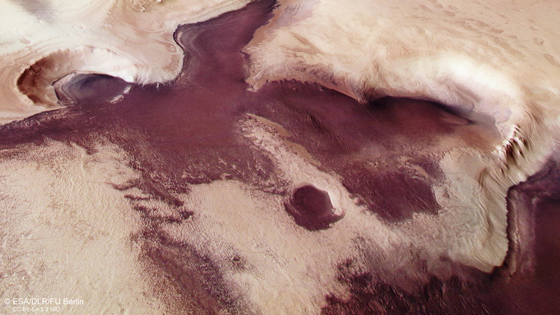
Dark angel at Mars South Pole • Position and scheme

Dark Angel Context map
Image Credit: MOLA Science Team/FU Berlin

Scheme for the creation of dust-devils
Image Credit: Modified after Ramon Peñas/The National/Free University of Berlin/FR Planetology and Remote Sensing
Dark angel at Mars South Pole • Images

Dark Angel HRSC color image
Image Credit: ESA/DLR/FU Berlin

Dark Angel HRSC color-coded terrain model
Image Credit: ESA/DLR/FU Berlin

Dark Angel HRSC anaglyph
Image Credit: ESA/DLR/FU Berlin
Christmas greetings from Mars
» read more about the Dark Angel on Mars
The dark angel and the heart, both consisting of volcanic sands, are located in the southern polar region of the planet, not far from the polar cap, at approximately 78 degrees south. Currently it is summer at this location. The permanent ice cap, consisting mostly of water ice and frozen carbon dioxide, now has a diameter of 400 kilometres and an average thickness of 1.5 kilometres. These are dimensions that are roughly comparable to the ice-covered island of Greenland on Earth. However, it is only this size in the southern summer. During the six-month winter, the south pole ice cap on Mars extends further, to almost 60 degrees south. Even in summer in the southern hemisphere of Mars, temperatures never rise above zero degrees Celsius. In winter, temperatures down to minus 133 degrees Celsius cause the carbon dioxide from the atmosphere to freeze and fall onto the ice cap as snow. This blanket of carbon dioxide ice is between one and two metres thick and sublimates again with the next spring, thus evaporating and re-exposing the landscape. Only on the permanent ice cap of the south pole does a thin layer remain. The atmosphere on Mars contains very little water vapour that can freeze to form ice. Water vapour forms only 0.02 percent of the planet's gas envelope, which consists mainly of carbon dioxide and nitrogen; on Earth, there is twenty times more water vapour in the atmosphere, averaging a concentration of 0.4 percent. Therefore, the angel and the heart are only visible in the southern summer; in winter they lie hidden under the layer of frozen carbon dioxide.
In the upper centre of the images, an impact crater approximately 15 kilometres across can be seen, in which dark sands form the 'angel's head’. With a little imagination, the almost one-thousand-metre-high crater rim can even be interpreted as a halo. In several places, the layered deposits of the polar cap, consisting of ice mixed with dust, are clearly visible on the upper slopes. Even in the oval depression that forms the 'angel's hand', the view of the layered polar deposits is unobstructed.
The southern part of the images is also covered by stratified deposits. These consist of ice and dust as well, but they are much more finely layered, thinner and cover the south polar deposits. This type of deposit covers large parts of the high latitudes of Mars (approximately between 40 and 80 degrees north and south respectively), which is why it is referred to as a 'latitude-dependent mantle'. In many places, degradation phenomena due to erosion and sublimation of the ice in spring and summer are visible in the mantle, which has created several small geological windows in which the finer layer structure can also be seen on close inspection.
In the centre of the images, beneath the angel's outstretched wing, is a large, heart-shaped depression bounded by a scarp leading to another large dark dune field. The dark material, consisting of olivine and pyroxene minerals, may have come from deeper layers of deposited volcanic eruptive material or could have been blown into the depression. In the latter case, the edges of the terrain would have acted as windbreaks, causing the sands to slow down and be deposited there. This dark material is distributed globally on Mars and forms imposing dune fields in countless impact craters.
On a very light-toned and flat surface, a large number of dust devil tracks (See scheme: Emergence of dust devils) can be spotted on the left side of the image crisscrossing each other as dark streaks. Those marks are left behind when dust devils blow away the dust cover of the surface on their path. An oval hollow (hand of the angel) appears to be a large sublimation pit, maybe formed around a crater and allowing a view on the layered structure of polar deposits.
High Resolution Stereo Camera (HRSC)
» information to image origin and processing
The images were acquired by the HRSC (High Resolution Stereo Camera) on 8 November 2020 during Mars Express Orbit 21305. The ground resolution is approximately 15 meters per pixel and the images are centered at about 148° East and 78° South. The color image was created using data from the nadir channel, the field of view which is aligned perpendicular to the surface of Mars, and the color channels of the HRSC. The oblique perspective view was generated from the digital terrain model, the nadir and color channels of HRSC. The anaglyph, which provides a three-dimensional view of the landscape when viewed using red-green or red-blue glasses, was derived from data acquired by the nadir channel and the stereo channels. The color-coded topographic view is based on a digital terrain model (DTM) of the region, from which the topography of the landscape can be derived. The reference body for the HRSC-DTM is a Mars equipotential surface (Areoid).
HRSC is a camera experiment that was developed and is operated by the German Aerospace Center (Deutsches Zentrum für Luft- und Raumfahrt; DLR).The systematic processing of the camera data took place at the DLR Institute for Planetary Research in Berlin-Adlershof. The working group of Planetary Science and Remote Sensing at Freie Universität Berlin used the data to create the image products shown here.
To download released raw images and DTMs of the region in GIS-ready formats, follow this link to the mapserver.
Images: ESA/DLR/FU Berlin, CC BY-SA 3.0 IGO
Copyright Notice:
Where expressly stated, images are licenced under the Creative Commons Attribution-ShareAlike 3.0 IGO (CC BY-SA 3.0 IGO) licence. The user is allowed to reproduce, distribute, adapt, translate and publicly perform it, without explicit permission, provided that the content is accompanied by an acknowledgement that the source is credited as 'ESA/DLR/FU Berlin', a direct link to the licence text is provided and that it is clearly indicated if changes were made to the original content. Adaptation / translation / derivatives must be distributed under the same licence terms as this publication.
The High Resolution Stereo Camera was developed at the German Aerospace Center (DLR) and built in collaboration with partners in industry (EADS Astrium, Lewicki Microelectronic GmbH and Jena-Optronik GmbH). The science team, which is headed by Principal Investigator (PI) Prof. Dr. Ralf Jaumann, consists of 52 co-investigators from 34 institutions and 11 countries. The camera is operated by the DLR Institute of Planetary Research in Berlin-Adlershof.