Marvellous Mars – from the North Pole to the Southern Highlands
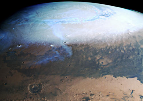
The upper part of this striking global view of Mars shows the northern hemisphere and the North Pole ice cap in winter. A thin veil of clouds stretches from there across the adjoining deep valleys, some of which are covered with dark sand. A prominent escarpment is visible in the image. This marks the border between Mars’ northern lowlands and its southern highlands. Dark sands also cover some areas of the crater-strewn highlands. In the extreme south (bottom) of the image, part of the Hellas impact crater is visible, covered by white clouds. The view of the planet is slightly tilted towards the south, allowing the North Pole to be seen, but it only extends down to 40 degrees south. The South Pole is therefore not visible. From pole to pole, Mars measures 6752 kilometres; the image shown here covers just under 5000 kilometres of that distance.
The reddish plains of Arabia Terra and Terra Sabaea in the centre of the image are notable for the presence of many large impact craters, indicating that they are among the oldest regions on Mars. Along their northern border is a striking escarpment, with a difference of several kilometres in height. This separates the flat, barely cratered plains of the northern lowlands from the southern highlands, which have many more craters. This remarkable change in terrain, referred to as the Martian dichotomy, marks a fundamental topographical and regional division on Mars. This is reflected, most importantly, in the different crust thicknesses, but also extends to the magnetic properties of the crust and its gravitational field. There is still a certain amount of scientific debate over how this crust dichotomy came about. It could have originated from endogenous forces in the Martian interior and thus been caused by mantle convection or tectonics. If exogenous (external) forces were responsible, this effect could perhaps be traced back to one or more major asteroid impacts.
The intensely rugged landscape at the dichotomy boundary has been severely eroded over millions of years, and is now characterised by numerous tectonic faults, mesas and river valleys. Observations have revealed that fluvial, aeolian and, in particular, glacial processes have altered the transition zone. Analysis of the image data suggests that there may have been several episodes of glacial activity during the evolution of Mars.