Department of Earth Sciences
Service Navigation
The Martian impact crater Lowell
The 200-kilometre-wide peak-ring impact crater shown in this High Resolution Stereo Camera (HRSC) image mosaic is named after the US astronomer Percival Lowell (1855 - 1916). HRSC is a camera system on board ESA’s Mars Express spacecraft, which has been orbiting Mars since 2003. Mars Express has flown over and imaged Lowell Crater several times in recent months.
» Read more about ring craters in the main article and below the gallery
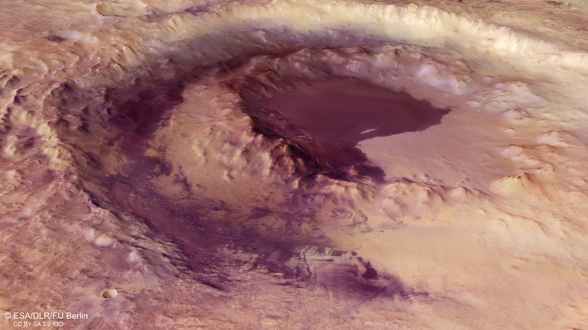
Lowell Crater • Images

HRSC color image
Image Credit: ESA/DLR/FU Berlin

HRSC color-coded terrain model
Image Credit: ESA/DLR/FU Berlin
Lowell Crater • Location and Schematic

context map
Image Credit: MOLA Science Team/FU Berlin

peak ring formation
Image Credit: modified after Melosh 1989
The Martian impact crater Lowell
» Read more about crater Lowell
Lowell Crater is named after the US mathematician, astronomer and writer Percival Lowell. A member of the Boston elite, in 1894 he founded the Lowell Observatory in Flagstaff, Arizona, for purposes including research into the planet Mars. Inspired by Giovanni Schiaparelli’s theories about canali (canals) on Mars, Lowell advanced the idea that these were drainage channels built by an intelligent civilisation. In 1905 he predicted the existence of a 'Planet X' beyond the orbit of Neptune. His theory proved to be correct, although Pluto was only discovered in 1930, some years after his death.
The impact crater, which is between 3.7 and 3.9 billion years old, is located in the Aonia Terra region of the southern Martian highlands. Over the course of millions of years, Lowell Crater has been altered by erosion and filled with sediments that have levelled the crater floor. Dark sand dunes, gullies and channels created by water run-off are visible along the inner rim of the crater. The impact ejecta are distributed radially over an area of the crater’s surroundings that extends for more than one crater diameter. There, it forms a star-shaped layer of debris that remains clearly visible in some places even today.
Special about Lowell crater is a ring of mountains 90 kilometers in diameter in the crater center. Similar peak-ring impact craters have been observed also on Earth, Venus, Mercury, and the Moon. In general, central peaks and peak-rings form by gravity-driven collapse and uplift of the floor following crater excavation. The collapse of craters of a certain diameter can give rise to a complex interior structure with flat floors, central peaks, wall terraces, and internal rings, whereas smaller impact craters have a simple bowl shape. The transition diameter of so-called simple to complex craters depends on the gravity of the planet, as well as on the target material strength. When a complex crater reaches a diameter of more than ~45 kilometers (Mars), or ~25 kilometers (Earth), the central uplift can create a ring of irregular mountain peaks in the crater center.
The investigation and simulations of data obtained from drilling expeditions of the 200-kilometer Chicxulub impact crater on peninsula Yucatán (Mexico) attributed peak-ring formation to the collapse of uplifted oversized, unstable central peaks. Consequently, the rocks forming peak rings originate from the deep subsurface of the impact site. The Chicxulub impact 66 million years ago is linked to the mass extinction of the dinosaurs.
High Resolution Stereo Camera (HRSC)
» Information to image origin and processing
The mosaic consists of seven orbit strips (2640, 2662, 2684, 16895, 18910, 18977, 18984) and covers a region 274.5° - 283° East and 49° - 54.5° South. Orbits 18910, 18977, and 18984 were covered in December 2018 and January 2019. The mosaic resolution is approximately 50 meters per pixel. The color mosaic was created using data from the nadir channels, the fields of view which are aligned perpendicular to the surface of Mars, and the color channels of the HRSC. The oblique perspective view was generated using data from the HRSC stereo channels. The color-coded topographic view is based on a digital terrain model (DTM) of the region, from which the topography of the landscape can be derived. The reference body for the digital terrain model is a Mars equipotential surface (Areoid).
The systematic processing of the camera data took place at the DLR Institute for Planetary Research in Berlin-Adlershof. The working group of Planetary Science and Remote Sensing at Freie Universität Berlin used the data to create the image products shown here.
Images: ESA/DLR/FU Berlin, CC BY-SA 3.0 IGO
Copyright Notice:
Where expressly stated, images are licenced under the Creative Commons Attribution-ShareAlike 3.0 IGO (CC BY-SA 3.0 IGO) licence. The user is allowed to reproduce, distribute, adapt, translate and publicly perform it, without explicit permission, provided that the content is accompanied by an acknowledgement that the source is credited as 'ESA/DLR/FU Berlin', a direct link to the licence text is provided and that it is clearly indicated if changes were made to the original content. Adaptation / translation / derivatives must be distributed under the same licence terms as this publication.
The High Resolution Stereo Camera was developed at the German Aerospace Center (DLR) and built in collaboration with partners in industry (EADS Astrium, Lewicki Microelectronic GmbH and Jena-Optronik GmbH). The science team, which is headed by Principal Investigator (PI) Prof. Dr. Ralf Jaumann, consists of 52 co-investigators from 34 institutions and 11 countries. The camera is operated by the DLR Institute of Planetary Research in Berlin-Adlershof.