Department of Earth Sciences
Service Navigation
Signs of ancient flowing water on Mars
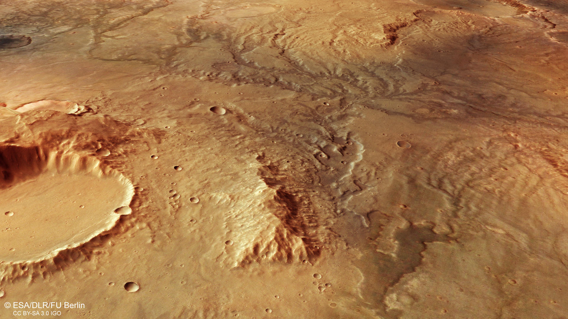
The latest images acquired using the High Resolution Stereo Camera (HRSC) on board ESA’s Mars Express mission show a system of desiccated fluvial valleys east of the large impact crater Huygens. Such valley networks typically occur in the oldest, most heavily cratered regions on Mars, which are situated in the southern highlands.
The HRSC experiment on board ESA's Mars Express mission orbits our neighbor planet Mars since 2003.
» Read more about valley networks on Mars in the main article and below the gallery
East of Huygens • Images

HRSC color image
Image Credit: ESA/DLR/FU Berlin

HRSC color-coded terrain model
Image Credit: ESA/DLR/FU Berlin

HRSC anaglyph
Image Credit: ESA/DLR/FU Berlin
East of Huygens • Location and Scheme

context map
Image Credit: MOLA Science Team/FU Berlin

dendritic network
Image Credit: drawn after Press&Siever 1995
Signs of ancient flowing water on Mars
» Read more about valley networks on Mars
The images show a network of meandering valleys across the landscape, all of which follow a dendritic, ramified or branched pattern. In hydrology, the term 'dendritic' is derived from 'dendron' (Greek for tree) and describes a valley into which, as one moves upstream, ever-smaller side valleys open, which in turn are fed by even smaller tributaries. This results in a pattern similar to the structure of a tree, with a trunk, branches and twigs. On Earth, this erosion pattern is found in most rivers and is the result of a water cycle with precipitation, runoff, evaporation and re-precipitation. In contrast, there are very few dendritic river valleys on Mars, and they have long since dried up. Most Martian valleys exhibit a different, rather straight structure with few tributaries, and they have a different origin – because they were formed by flowing groundwater.
The region is located in the southern highlands of Mars, east of the 450-kilometer-diameter impact crater Huygens and north of Hellas, the largest impact basin on Mars.
For such dendritic valleys to form, running water had to have been present on Mars. The various sources of this water – precipitation, groundwater or glacial meltwater – can often be determined by examining the valley structure. Martian valley networks with a dendritic layout were most likely formed by surface runoff of precipitation or meltwater. The heads of the valleys are typically located on a topographical ridge such as a watershed, and the course of the runoff channels follows the local gradient. The term ‘watershed’ refers to the boundary between two adjacent river systems, which usually extend along ridges.
As can be deduced from the color-coded elevation model, the water flowed from north (on the right in the image) to south. The largest valleys in the images are up to two kilometers wide, and reach a depth of up to 200 meters. In particular, those that run in an east-west direction show heavily eroded valley edges, scoured by the erosive power of the water flowing down the valley.
Today, it is thought that climate change took place on Mars about 3.7 to 3.8 billion years ago, when environmental conditions changed from a somewhat neutral, potentially life-sustaining and sporadically humid environment to a much more acidic, dry, cold environment that is hostile to life. The main reason for this, according to current knowledge, was the gradual loss of the Martian atmosphere and a change in the planet's volcanic activity.
One of the reasons why Mars lost its atmosphere is the loss of its magnetic field, which was active during the first 500 million years. As it grew ever weaker the solar wind was able to gradually split the molecules in the atmosphere, and the resultant ions were accelerated and lost to space. As a result, and also due to the declining volcanism, the atmosphere became thinner and thinner. In addition, Mars is only half the size of Earth, so its gravitational force is barely sufficient to bind atmospheric molecules to it. Below a certain atmospheric pressure, water can no longer remain liquid on the surface of a planet – it can remain as ice or gas. The lack of precipitation on Mars ultimately collapsed the water cycle.
Due to the current, very thin atmosphere, liquid water on the surface of Mars cannot be stable. Even if the temperature was favorable, it would evaporate immediately. However, beneath the surface it still seems to be abundant – in the form of water ice. The two polar ice caps on Mars also consist of a mixture of frozen water and carbon dioxide ice. Under very extreme conditions (for example, in very saline environments), liquid water could theoretically still exist for a short time on Mars.
High Resolution Stereo Camera (HRSC)
» Information to image origin and processing
The images were acquired by the HRSC (High Resolution Stereo Camera) on 19 November 2018 during Mars Express Orbit 18831. The ground resolution is approximately 14 meters per pixel and the images are centered at about 66° East and 17° South. The color image was created using data from the nadir channel, the field of view which is aligned perpendicular to the surface of Mars, and the color channels of the HRSC. The oblique perspective view was generated from the digital terrain model, the nadir and color channels of HRSC. The anaglyph, which provides a three-dimensional view of the landscape when viewed using red-green or red-blue glasses, was derived from data acquired by the nadir channel and the stereo channels. The color-coded topographic view is based on a digital terrain model (DTM) of the region, from which the topography of the landscape can be derived. The reference body for the HRSC-DTM is a Mars equipotential surface (Areoid).
The systematic processing of the camera data took place at the DLR Institute for Planetary Research in Berlin-Adlershof. The working group of Planetary Science and Remote Sensing at Freie Universität Berlin used the data to create the image products shown here.
Images: ESA/DLR/FU Berlin, CC BY-SA 3.0 IGO
Copyright Notice:
Where expressly stated, images are licenced under the Creative Commons Attribution-ShareAlike 3.0 IGO (CC BY-SA 3.0 IGO) licence. The user is allowed to reproduce, distribute, adapt, translate and publicly perform it, without explicit permission, provided that the content is accompanied by an acknowledgement that the source is credited as 'ESA/DLR/FU Berlin', a direct link to the licence text is provided and that it is clearly indicated if changes were made to the original content. Adaptation / translation / derivatives must be distributed under the same licence terms as this publication.
The High Resolution Stereo Camera was developed at the German Aerospace Center (DLR) and built in collaboration with partners in industry (EADS Astrium, Lewicki Microelectronic GmbH and Jena-Optronik GmbH). The science team, which is headed by Principal Investigator (PI) Prof. Dr. Ralf Jaumann, consists of 52 co-investigators from 34 institutions and 11 countries. The camera is operated by the DLR Institute of Planetary Research in Berlin-Adlershof.