Department of Earth Sciences
Service Navigation
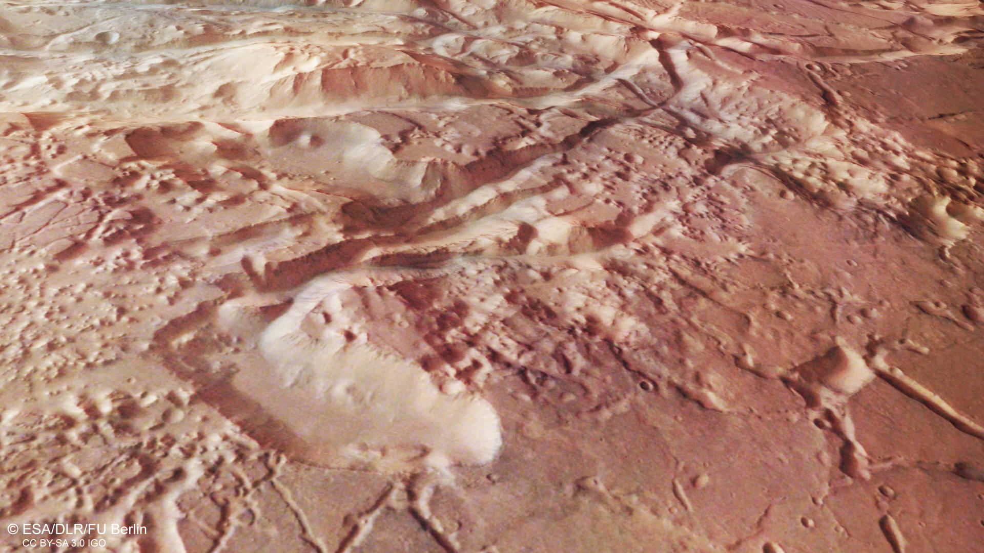
Aurorae Chaos – catastrophic collapse by water masses?
The rugged and fractured terrain with numerous peaks and mesas captured by these High Resolution Stereo Camera (HRSC) images is located in the Margaritifer Terra region on Mars. It shows the southern part of Aurorae Chaos, a region altered by water-driven collapse. HRSC is a camera experiment that was developed and is operated by the German Aerospace Center (Deutsches Zentrum für Luft- und Raumfahrt; DLR), and mounted on board the ESA Mars Express mission, orbiting Mars since 2003.
» Read more about aurorae chaos in the main article and below the gallery
Aurorae Chaos • Images

HRSC color image
Image Credit: ESA/DLR/FU Berlin

HRSC color-coded terrain model
Image Credit: ESA/DLR/FU Berlin

HRSC anaglyph
Image Credit: ESA/DLR/FU Berlin
Aurorae Chaos • Location

context map
Image Credit: MOLA Science Team/FU Berlin
Aurorae Chaos – catastrophic collapse by water masses?
» Read more about aurorae chaos
Aurorae Chaos is part of a large-scale system of depressions east of the Valles Marineris canyon. The up to 600 kilometers wide irregular shaped basin has a depth of about four kilometers with respect to the surrounding plains. The random pattern of mesas, buttes and knobs on the basin floor is characteristic of so-called 'chaotic terrain', a landscape special to Mars without an Earth analog. In the old highland region of Margaritifer Terra around the Martian equator, numerous chaotic terrains crosscut the highland plateau.
In the image center, a prominent scarp runs through the scene from northeast to south-west, and connects the southern plateau to the northern low-lying region of Aurorae Chaos. The transition area shows fractures and graben resulting from crustal stretching, which are oriented parallel or inclined to the scarp. In addition, smaller chaos regions can be made out to the south of the escarpment (left in image).
Chaotic terrains visible on the Martian surface today indicate a complex history of transport, storage, and release of large amounts of water in the past. Scientists believe these areas formed by collapse of a surface overlying a reservoir containing ice and sediments, when the ice melted due to, e.g., a volcanic or impact heat source. After drainage of the water masses, broken surface blocks remained in the cavity that previously hosted ice and sediments. Possibly, groundwater as well as magma upwelling could have occurred during collapse in addition to the release of meltwater. For Aurorae Chaos, crater size-frequency distribution measurements yielded a model age of 3.5 billion years for the basin floor, indicating collapse happened long time ago.
There are numerous mineralogical references of the early presence of liquid water in and around chaotic terrains on Mars. Sulphate-containing layers of sediment identified in some of the basins that host chaotic terrains point to evaporative processes. Clay-bearing deposits on the plateau units of Margaritifer Terra, predating the sulfate deposits in the chaotic terrains, probably resulted from fracturing and groundwater outflow. The formation of clay minerals would have required the presence of standing, pH-neutral water.
High Resolution Stereo Camera (HRSC)
» Information to image origin and processing
The images were acquired by the HRSC (High Resolution Stereo Camera) on 31 October 2018 during Mars Express Orbit 18765. The ground resolution is approximately 14 meters per pixel and the images are centered at about 327° East and 11° South. The color image was created using data from the nadir channel, the field of view which is aligned perpendicular to the surface of Mars, and the color channels of the HRSC. The oblique perspective view was generated from the digital terrain model, the nadir and color channels of HRSC. The anaglyph, which provides a three-dimensional view of the landscape when viewed using red-green or red-blue glasses, was derived from data acquired by the nadir channel and the stereo channels. The color-coded topographic view is based on a digital terrain model (DTM) of the region, from which the topography of the landscape can be derived. The reference body for the HRSC-DTM is a Mars equipotential surface (Areoid).
The systematic processing of the camera data took place at the DLR Institute for Planetary Research in Berlin-Adlershof. The working group of Planetary Science and Remote Sensing at Freie Universität Berlin used the data to create the image products shown here.
Images: ESA/DLR/FU Berlin, CC BY-SA 3.0 IGO
Copyright Notice:
Where expressly stated, images are licenced under the Creative Commons Attribution-ShareAlike 3.0 IGO (CC BY-SA 3.0 IGO) licence. The user is allowed to reproduce, distribute, adapt, translate and publicly perform it, without explicit permission, provided that the content is accompanied by an acknowledgement that the source is credited as 'ESA/DLR/FU Berlin', a direct link to the licence text is provided and that it is clearly indicated if changes were made to the original content. Adaptation / translation / derivatives must be distributed under the same licence terms as this publication.
The High Resolution Stereo Camera was developed at the German Aerospace Center (DLR) and built in collaboration with partners in industry (EADS Astrium, Lewicki Microelectronic GmbH and Jena-Optronik GmbH). The science team, which is headed by Principal Investigator (PI) Prof. Dr. Ralf Jaumann, consists of 52 co-investigators from 34 institutions and 11 countries. The camera is operated by the DLR Institute of Planetary Research in Berlin-Adlershof.