Department of Earth Sciences
Service Navigation
From hills to valleys – material transport on Mars
The region shown on these High Resolution Stereo Camera (HRSC) images is located at the so-called dichotomy boundary, a topographic scarp between the southern highlands and the northern lowlands of Mars. Mesas, valleys and numerous small hills characterize the landscape, shaped by water-driven erosional processes.
The HRSC experiment is carried on board the ESA mission Mars Express, orbiting Mars since 2003.
» Read more about a Martian landscape shaped by water and ice in the main article (below the gallery) ...
From Hills to Valleys • Views

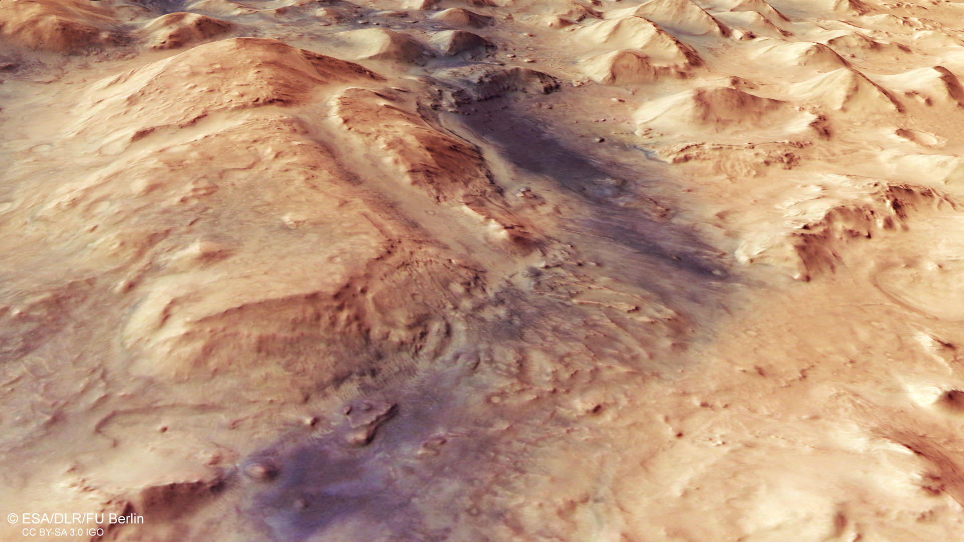
HRSC color image
Image Credit: ESA/DLR/FU Berlin

HRSC color-coded terrain model
Image Credit: ESA/DLR/FU Berlin

HRSC anaglyph
Image Credit: ESA/DLR/FU Berlin
From Hills to Valleys • Location and Perspective

context map
Image Credit: MOLA Science Team/FU Berlin

HRSC perspective view
Image Credit: ESA/DLR/FU Berlin
From hills to valleys – material transport on Mars
» Read more about a Martian landscape shaped by water and ice
The images show a hilly landscape scored through by a myriad of furrows. This area lies on what is known as Mars' dichotomy boundary, or sometimes as the highland-lowland boundary. The pronounced dichotomy between the crater-strewn highlands south of the equator and the smooth northern lowlands, is one of Mars' most striking topographical features. In most places, the transition between the two is marked by a steep terrain edge, with numerous inselbergs or outlier mountains at the foothill, which represent the remnants of the highlands and were able to withstand the processes of erosion for a longer period of time. Traces of glacier activity and ice can often be seen along the dichotomy boundary, indicating the presence of ice in the past.
The southern region, with its plateau-like rocks (on the left of the image), is significantly higher than areas further north (on the right of the image), which mainly consist of smaller mesas and hills. These are interspersed with depressions that formed through erosion processes during the planet’s past. Water and ice transported the rocky material downslope into areas of lower elevation millions of years ago. The narrow valleys bear particularly clear traces of these flow processes, with line-like structures that show where material was transported by water or ice. The elevations in the adjacent northern lowlands are testament to the former level of the terrain and are thought to consist of more resistant material.
Some materials in the low-lying areas, especially in the western (upper) part of the image, show signs of alteration by water. Spectrometer experiments, e.g. OMEGA on board Mars Express, have detected clay minerals in this region, which have water molecules embedded into their crystal structure. The presence of these hydrous minerals has implications for the formation conditions and for the former climate on Mars.
High Resolution Stereo Camera (HRSC)
» Information to image origin and processing
The images were acquired by the HRSC (High Resolution Stereo Camera) on 26 February 2018 during Mars Express Orbit 17916. The ground resolution is approximately 18 meters per pixel and the images are centered at about 78° East and 28° North. The color image was created using data from the nadir channel, the field of view which is aligned perpendicular to the surface of Mars, and the color channels of the HRSC. The oblique perspective view was generated using data from the HRSC stereo channels. The anaglyph, which provides a three-dimensional view of the landscape when viewed using red-green or red-blue glasses, was derived from data acquired by the nadir channel and the stereo channels. The color-coded topographic view is based on a digital terrain model (DTM) of the region, from which the topography of the landscape can be derived. The reference body for the HRSC-DTM is a Mars equipotential surface (Areoid).
The systematic processing of the camera data took place at the DLR Institute for Planetary Research in Berlin-Adlershof. The working group of Planetary Science and Remote Sensing at Freie Universität Berlin used the data to create the image products shown here.
Images: ESA/DLR/FU Berlin, CC BY-SA 3.0 IGO
Copyright Notice:
Where expressly stated, images are licenced under the Creative Commons Attribution-ShareAlike 3.0 IGO (CC BY-SA 3.0 IGO) licence. The user is allowed to reproduce, distribute, adapt, translate and publicly perform it, without explicit permission, provided that the content is accompanied by an acknowledgement that the source is credited as 'ESA/DLR/FU Berlin', a direct link to the licence text is provided and that it is clearly indicated if changes were made to the original content. Adaptation / translation / derivatives must be distributed under the same licence terms as this publication.
The High Resolution Stereo Camera was developed at the German Aerospace Center (DLR) and built in collaboration with partners in industry (EADS Astrium, Lewicki Microelectronic GmbH and Jena-Optronik GmbH). The science team, which is headed by Principal Investigator (PI) Prof. Dr. Ralf Jaumann, consists of 52 co-investigators from 34 institutions and 11 countries. The camera is operated by the DLR Institute of Planetary Research in Berlin-Adlershof.