Department of Earth Sciences
Service Navigation
15 years HRSC on Mars Express – Mars from horizon to horizon
On 2nd June 2018 is the 15th anniversary of the launch of the European Mars Express spacecraft. Still in orbit around Mars today, it marks one of the most successful space missions ever send to Mars.
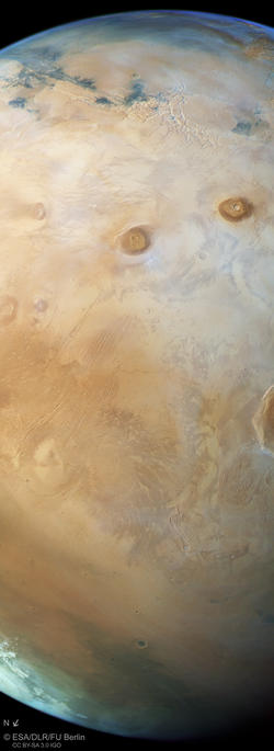
One of the instruments still working is the German High Resolution Stereo Camera (HRSC) experiment. In October 2017 HRSC captured a spectacular global view of Mars, revealing the beauty of our neighbor planet that featured active volcanoes millions of years ago. HRSC operations and the systematic processing of the image data were carried out at DLR. The views shown here were created by the Planetary Sciences and Remote Sensing group at Freie Universität Berlin.
During the last 15 years the HRSC instrument has done an incredible good job in obtaining images of our neighbor planet Mars in all its facets. This image is one out of more than 1000 HRSC views and movies that have been released by ESA, DLR and FU Berlin since the start of the Mars Express mission on 2nd June 2003. The labeled version of the image leads to a selection of spectacular HRSC Mars images from the extensive press archive.
» Read more about the Tharsis volcanic province and about volcanism on Mars in the main article (below the gallery) ...
Gallery • Overview Maps

MOLA Mars Map
HRSC orbit coverage on Mars Orbiter Laser Altimeter (MOLA) map
Image Credit: NASA/MGS/MOLA Science Team, FU Berlin

Viking Mars Map
HRSC orbit coverage on Viking map
Image Credit: NASA/Viking, FU Berlin
Gallery • Imaging Principle and Color View of Mars

HRSC Imaging Principle
Fly-over of Mars Express in orbit 17444 from North to South (North is down in the images)
Image Credit: FU Berlin/ESA/NASA

HRSC Color View of Mars
Tharsis volcanis province and Valles Marineris canyon on Mars
Image Credit: ESA/DLR/FU Berlin
Main article 'Mars from horizon to horizon'
» Read more about the Tharsis volcanic province and about volcanism on Mars
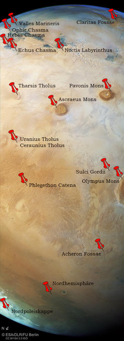
Huge volcanoes, deep canyons, fractured ground – the Tharsis volcanic province that was covered here by HRSC in a wide swath is among the geologically most interesting and also most investigated regions on Mars. The image recorded by HRSC cuts across Tharsis from the northwest to the southeast: from the north polar ice cap in the lower left corner of the image over the giant volcanoes Alba Mons, a part of Olympus Mons, Ascraeus and Pavonis Mons that emerge over the cloud cover as darker spots, and finally the web-like Noctis Labyrinthus and the Valles Marineris canyon system with its characteristic dark-colored deposits in the upper left. A pale blue atmospheric haze marks the upper horizon which is situated near the equator.
Tharsis is a former volcanically and tectonically active region near the Martian equator covering one quarter of the surface of Mars and hosting most of the gigantic Martian volcanoes. This region rises 10 kilometers above the Martian datum, a reference that defines zero absolute altitude since there is no sea level on Mars. Tharsis volcanism is related to multiple volcanic centers of which the oldest one is situated in the Thaumasia region of the southern highlands (visible in the upper right corner of the image). Other, later active volcanic centers are situated in Syria Planum, at Pavonis and Alba Mons. A number of radiating and circumferential dike swarms in the Tharsis region can be traced back to these volcanic centers.
The development of different volcanic centers in Tharsis required a feeding source for the magma, which might have been a single mantle plume or multiple plumes possibly migrating over time. Mantle plumes are mushroom-like bodies of molten rock within the viscous Martian mantle which have a higher temperature and a lower density compared to the surrounding material, rising up to below the upper, elastic layer of the planet, the lithosphere. Such a hot, upwelling mantle can create intrusions, magma chambers and large igneous provinces.
In the upper left of the image one can find the Valles Marineris canyon system whose origin and development is closely related to the Tharsis volcanic province. Dynamic models show that the emplacement of the Tharsis rise onto the crustal dichotomy boundary, which is a topographic step separating the northern lowlands from the southern highlands, led to tension and crustal rupture at the present-day location of Valles Marineris. As a consequence, intrusives of molten rock filled the fissures created by the crustal rupture, and formed so called dikes which acted to destabilize and decouple the crustal blocks from each other. Subsidence of the blocks then created troughs and canyons that later grew in width by the collapse of wall material. The web-like pattern of troughs in Noctis Labyrinthus at the western end of Valles Marineris can be explained by interacting stress patterns.
What is special about the color image of Mars shown here is that it pictures the upper as well as the lower horizon in a global view. This image is one out of more than 1000 HRSC views and movies that have been released by ESA, DLR and FU Berlin since the start of the Mars Express mission on 2nd June 2003. During the last 15 years the HRSC instrument has done an incredible good job in obtaining images of our neighbor planet Mars in all its facets. Even now, after more than 18,000 orbits around Mars, HRSC is still reliably transmitting data to Earth that extends our knowledge of the Red Planet.
High Resolution Stereo Camera (HRSC)
Information to image origin and processing
The images were acquired by the HRSC (High Resolution Stereo Camera) on 12 October 2017 during Mars Express Orbit 17444. The ground resolution in the center of the image is approximately one kilometer per pixel and the images are centered at 245° East and 25° North. The color image was created using data from the nadir channel, the field of view which is aligned perpendicular to the surface of Mars, and the color channels of the HRSC. The context maps are based on data of the Viking mission and of the Mars Orbiter Laser Altimeter (MOLA) experiment onboard the Mars Global Surveyor (MGS) mission of NASA.
HRSC color view of Mars: ESA/DLR/FU Berlin, CC BY-SA 3.0 IGO
HRSC imaging principle: FU Berlin/ESA/NASA
Context map rainbow color: NASA/MGS/MOLA Science Team, FU Berlin
Context map Mars color: NASA/Viking, FU Berlin
Copyright Notice:
Where expressly stated, images are licenced under the Creative Commons Attribution-ShareAlike 3.0 IGO (CC BY-SA 3.0 IGO) licence. The user is allowed to reproduce, distribute, adapt, translate and publicly perform it, without explicit permission, provided that the content is accompanied by an acknowledgement that the source is credited as 'ESA/DLR/FU Berlin', a direct link to the licence text is provided and that it is clearly indicated if changes were made to the original content. Adaptation/translation/derivatives must be distributed under the same licence terms as this publication.
The High Resolution Stereo Camera was developed at the German Aerospace Center (DLR) and built in collaboration with partners in industry (EADS Astrium, Lewicki Microelectronic GmbH and Jena-Optronik GmbH). The science team, which is headed by Principal Investigator (PI) Prof. Dr. Ralf Jaumann, consists of 52 co-investigators from 34 institutions and 11 countries. The camera is operated by the DLR Institute of Planetary Research in Berlin-Adlershof.