Olympia Planum - Dunes, Layers and a Wall of Ice
Image data, taken by the High Resolution Stereo Camera (HRSC) on board ESA’s Mars Express show a fascinating scene from the north polar region of the planet. HRSC is a camera experiment that was developed and is operated by the German Aerospace Center (Deutsches Zentrum für Luft- und Raumfahrt; DLR).
» read more in the main article below...
Olympia Planum • Position & 3D view

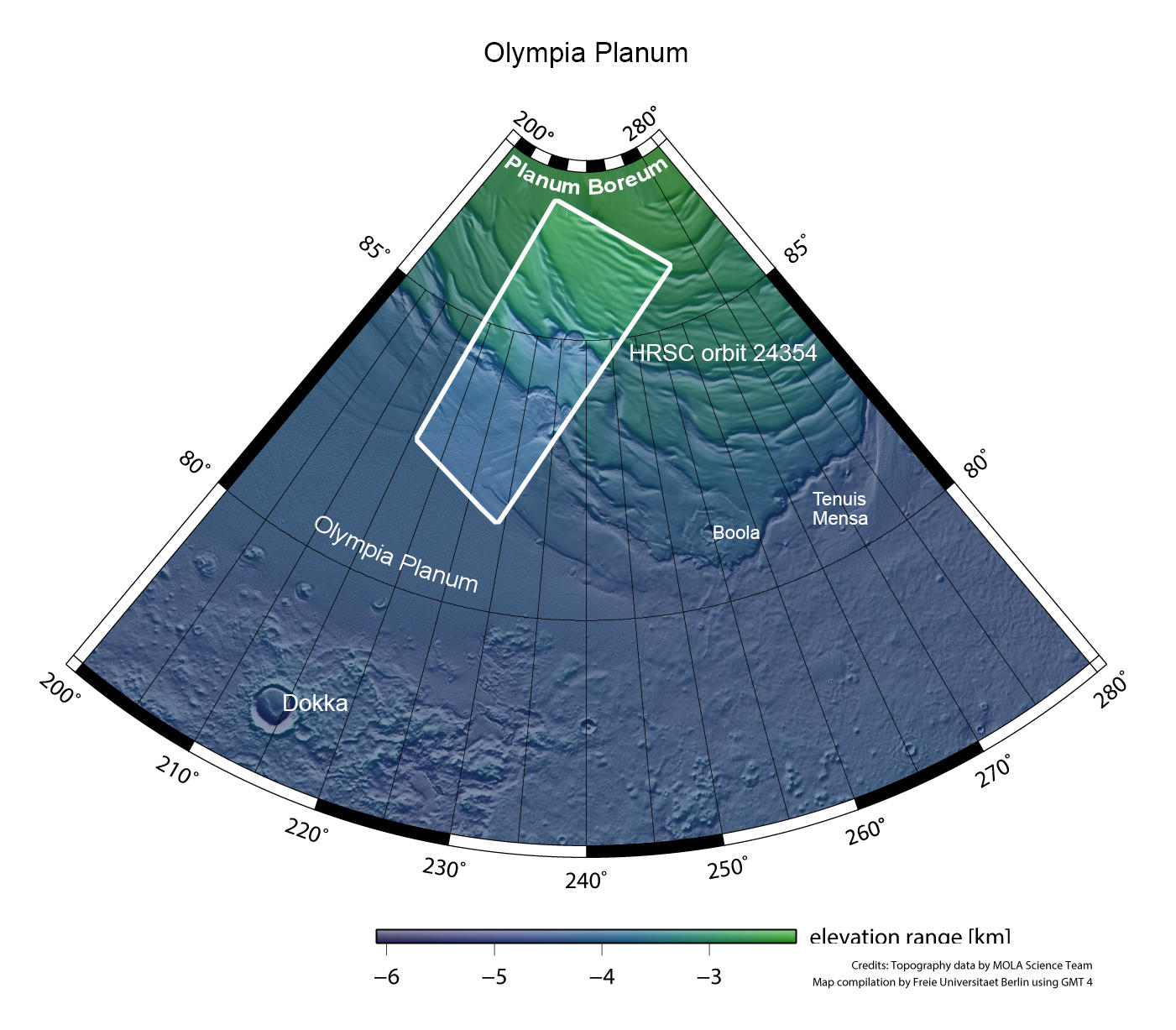
Olympia Planum - Context Map
Image Credit: MOLA Science Team/FU Berlin

Olympia Planum - 3D
Image Credit: ESA/DLR/FU Berlin

Olympia Planum - 3D-2
Image Credit: ESA/DLR/FU Berlin
Olympia Planum • HRSC images

Olympia Planum - Color-coded Terrain Model
Image Credit: ESA/DLR/FU Berlin

Olympia Planum - HRSC Color
Image Credit: ESA/DLR/FU Berlin

Olympia Planum - HRSC Annotated
Image Credit: ESA/DLR/FU Berlin

Olympia Planum - Anaglyph
Image Credit: ESA/DLR/FU Berlin
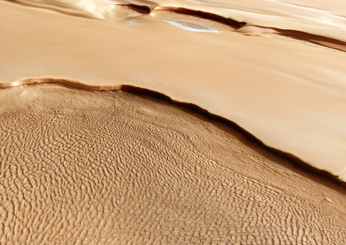
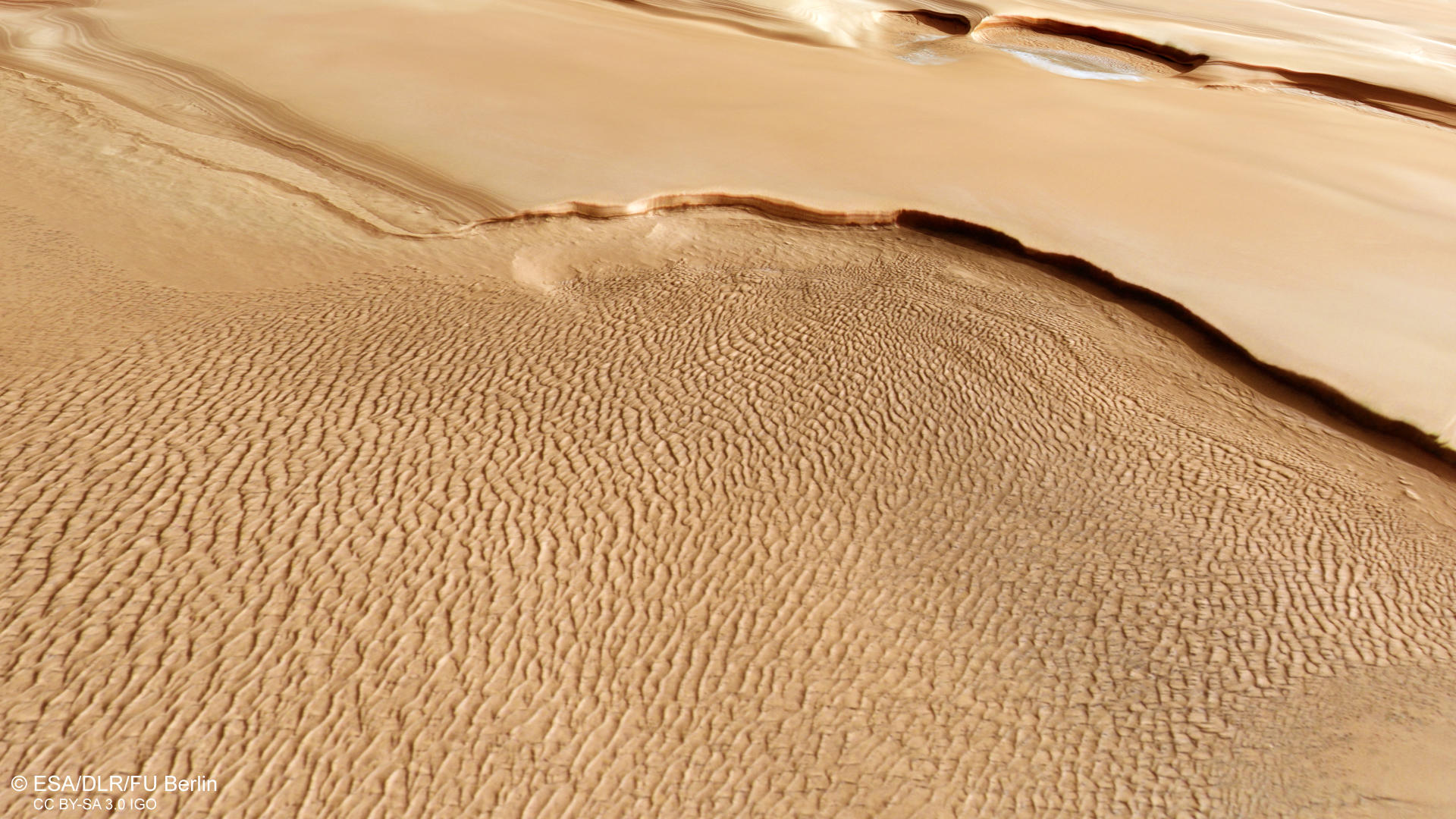
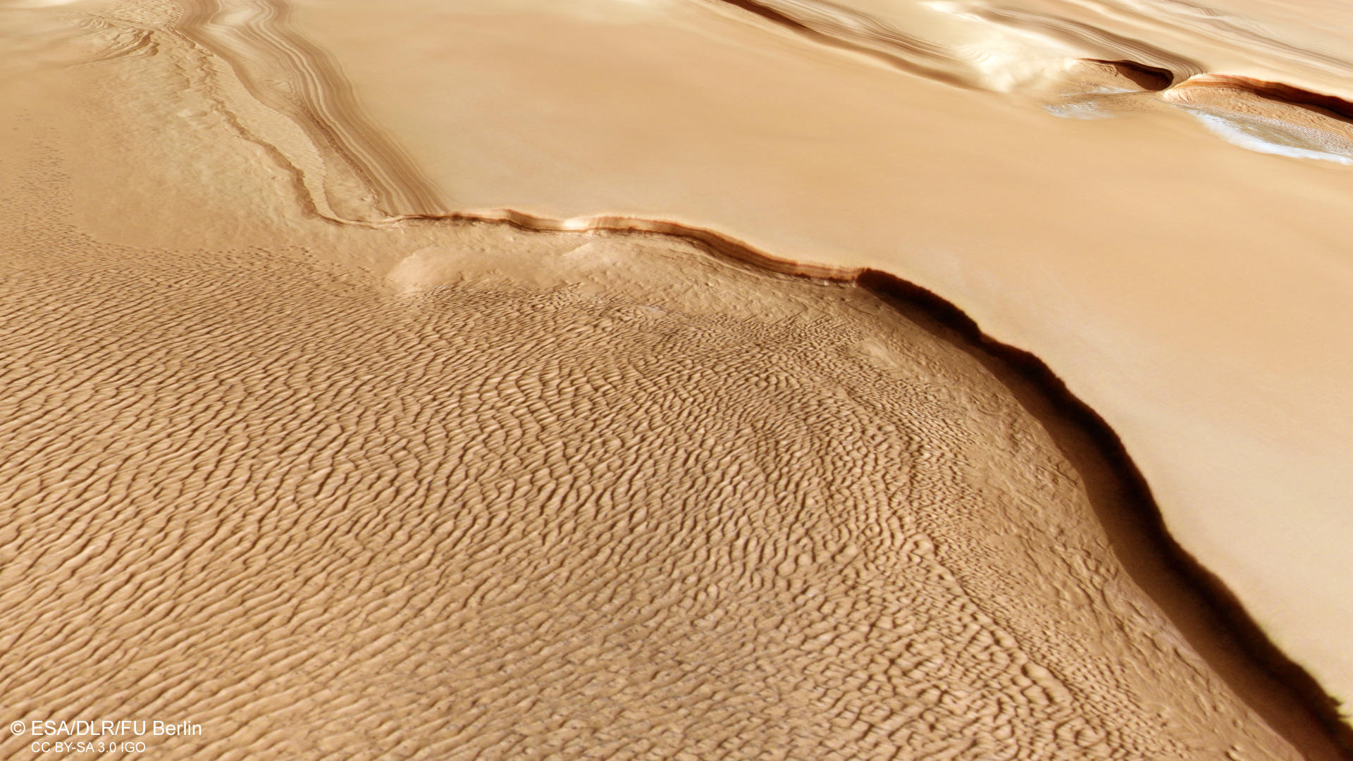
Olympia Planum – Dunes, Layers and a Wall of Ice
This HRSC image shows the scarps demarking the boundary between the layered deposits covering the north polar region of Mars and the lower surrounding terrain exhibiting large dune fields. The North Polar layered deposits represent a up to 3-kilometer thick stack of dusty water ice layers, about 1000 kilometers across. The layers record information about the climate, stretching back a few million years into Martian history. The deposits are formed by atmospheric fallout of dust and water ice and direct frost condensation. They are characterized by continuous sub-horizontal layers, mostly composed of water ice and of up to 10-15% fine dust sediments. It is important to mention, that the north polar ice cap of Mars also shows a thin, 1 to 2 m thick seasonal cap of dry ice (CO2) which in summer completely sublimates into the atmosphere.
The right part of the image shows a smooth and pristine appearing surface with some visible layering, but untouched by impact cratering processes. This means, that the surface is very young, probably rejuvenating every Martian year. Two large semicircular cliffs, the larger one measuring 20 km in diameter can be found. They are located at a so-called polar trough, a morphologic feature created by the erosional force of the wind. These clockwise oriented troughs create the characteristic spiral pattern of the polar plateau. The cliffs presented in this HRSC observation display a vertical wall of layered ice, in some places more than a kilometer high. Very well visible are the sharp shadows underlining the steepness of the cliffs. This becomes strikingly clear by looking at the anaglyph image. At the base of the cliffs, erosional features can be spotted exposing more layers and also large frost covered dune fields. In summer, these dunes will show a very dark to black color. The left part of the image is dominated by a giant elongated dune field, stretching for more than 150 km within this image. It looks as if the sands building up this dune field could originate from erosion of the polar deposits at the large scarp visible here.
Surrounding the north polar region at greater distance are the so-called Olympia Undae, a vast dune field covering an area of 470 000 km2 from 78° to 83°N latitude (larger than Sweden, about the size of the whole Balkan peninsula). Already in 2005, shortly after the arrival at Mars of the Mars Express orbiter, the OMEGA instrument detected high gypsum concentrations on the dunes of Olympia Undae. These dunes are intriguing due to their unique gypsum composition, proximity to the polar ice deposits, and seasonal variations.
High Resolution Stereo Camera (HRSC)
The images were acquired by the HRSC (High Resolution Stereo Camera) on 14 April 2023 during Mars Express Orbits 24354. The ground resolution is approximately 21 meters per pixel and the image is centered at about 231° East and 84° North. The color image was created using data from the nadir channel, the field of view which is aligned perpendicular to the surface of Mars, and the color channels of the HRSC. The oblique perspective view was generated from the digital terrain model, the nadir and color channels of HRSC. The anaglyph image, which creates a three-dimensional impression of the landscape when viewed with red/blue or red/green glasses, was derived from the nadir channel and one stereo channel. The color-coded topographic view is based on a DTM of the region, from which the topography of the landscape can be derived. The reference body for the HRSC-DTM is a Mars equipotential surface (Areoid).
HRSC is a camera experiment that was developed and is operated by the German Aerospace Center (Deutsches Zentrum für Luft- und Raumfahrt; DLR). The systematic processing of the camera data took place at the DLR Institute for Planetary Research in Berlin-Adlershof. The working group of Planetary Science and Remote Sensing at Freie Universität Berlin used the data to create the image products shown here.
To download released raw images and DTMs of the region in GIS-ready formats, follow this link to the mapserver.
Images: ESA/DLR/FU Berlin, CC BY-SA 3.0 IGO
Copyright Notice:
Where expressly stated, images are licenced under the Creative Commons Attribution-ShareAlike 3.0 IGO (CC BY-SA 3.0 IGO) licence. The user is allowed to reproduce, distribute, adapt, translate and publicly perform it, without explicit permission, provided that the content is accompanied by an acknowledgement that the source is credited as 'ESA/DLR/FU Berlin', a direct link to the licence text is provided and that it is clearly indicated if changes were made to the original content. Adaptation / translation / derivatives must be distributed under the same licence terms as this publication.
The High Resolution Stereo Camera was developed at the German Aerospace Center (DLR) and built in collaboration with partners in industry (EADS Astrium, Lewicki Microelectronic GmbH and Jena-Optronik GmbH). The science team, which is headed by Principal Investigator (PI) Dr. Daniela Tirsch, consists of 52 co-investigators from 34 institutions and 11 countries. The camera is operated by the DLR Institute of Planetary Research in Berlin-Adlershof.