Flight over Mawrth Vallis
The Martian outflow channel Mawrth Vallis is a candidate landing site for ESA’s ExoMars 2020 mission. The movie was created out of image data from the High Resolution Stereo Camera (HRSC) on board Mars Express by the Planetary Sciences and Remote Sensing group at Freie Universität Berlin. The systematic processing of the HRSC image data was carried out at German Aerospace Center (DLR).
Mawrth Vallis is situated at the boundary of the southern highlands to the northern lowlands on Mars and has a length of 600 km and a depth of up to 2 km. The presented animation is based on a color mosaic and digital terrain model of the region released July 7, 2016.
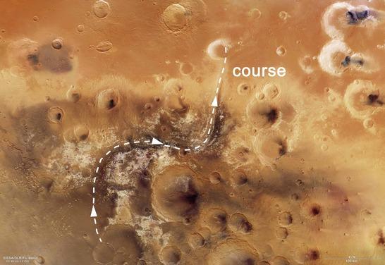
Course Mawrth Vallis Animation
Starting at the mouth of the channel in Chryse Planitia, the flyover heads along the channel to the source region in the Arabia Terra highlands. The 4 billion years old plateau is characterized by many impact craters, light and dark deposits. The light-toned layered sediments are among the largest outcrops of phyllosilicates (clay minerals) on Mars and an indication of past surface alteration by liquid water.
The variety of hydrated, i.e. water-bearing, minerals and the possibility of a habitable environment in the Martian past led scientists to propose Mawrth Vallis as a candidate landing site for the ExoMars 2020 mission.
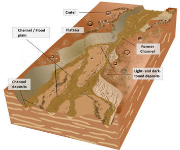
Sketch River System
Image processing and the HRSC experiment on Mars Express
The underlying mosaic consists of 9 orbit strips (1564, 1337, 2229, 1542, 1326, 1293, 2938, 2196, 3297) and covers a region 338°-346° East and 17°-29° North. The color mosaic was created using data from the nadir channel, the field of view of which is aligned perpendicular to the surface of Mars, and the color channels of the HRSC. The mosaic image is combined with topography information (from stereo data of HRSC) to generate a three-dimensional landscape. Finally this landscape is recorded from different perspectives, as with a movie camera, to render a flight.
Mapserver
To download released raw images and dtms of the region in GIS-ready formats, follow this link to the mapserver.
Copyrights
Animation: ESA/DLR/FU Berlin, CC BY-SA 3.0 IGO
Music: Ars Sonor, CC BY 4.0 and Adrian Neesemann
Copyright Notice:
This video (without music) is licenced under the Creative Commons Attribution-ShareAlike 3.0 IGO (CC BY-SA 3.0 IGO) licence. The user is allowed to reproduce, distribute, adapt, translate and publicly perform it, without explicit permission, provided that the content is accompanied by an acknowledgement that the source is credited as 'ESA/DLR/FU Berlin', a direct link to the licence text is provided and that it is clearly indicated if changes were made to the original content. Adaptation/translation/derivatives must be distributed under the same licence terms as this publication.
The High Resolution Stereo Camera was developed at the German Aerospace Center (DLR) and built in collaboration with partners in industry (EADS Astrium, Lewicki Microelectronic GmbH and Jena-Optronik GmbH). The science team, which is headed by Principal Investigator (PI) Ralf Jaumann, consists of 52 co-investigators from 34 institutions and 11 countries. The camera is operated by the DLR Institute of Planetary Research in Berlin-Adlershof.