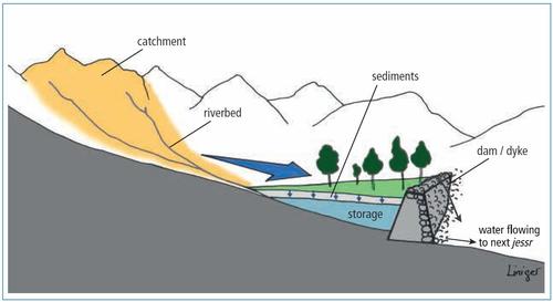
Jessour systems
Jessour systems are located in upper zones of (semi) arid highlands with medium to high slopes, less than 200 mm rainfall annually, and are a variation of riverbed reclamation. They consist of three components: the catchment, the terrace and the dyke. The dyke (also called tabia) made from soil, rock, or gabions, is either built across seasonal stream channels or at the foot of slopes. Fertile sediments accumulate behind the dykes allowing the cropping of trees and annual crops. The jessour system is used for the cultivation of a number of trees including olives, figs, almonds, and palms – as well as legumes (peas, chickpeas, lentils and faba bean), and cereals (wheat and barley). The cropping area is in the range of 0.2 – 5 ha and the ratio of the catchment to application / target area varies from 100:1 to 10,000:1. The main functions of jessours are: (1) soil moisture increase for crops, (2) groundwater recharge through infiltration in the terraces and (3) flood control and therefore protection of downstream infrastructure. Similar systems, called “warping” and gavias, exists in the loess plateau of China and in arid zones of the Canary archipelago, respectively. (Mekdaschi & Liniger 2013)
