Methods of assessment and data preparation
Methods used to assess the landscape sensitivity of the Gina River catchment. The approaches to assess soil erosion you can study by following this hyperlink.
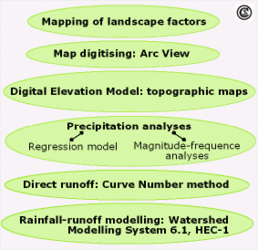
One part of environmental analysis might be the assessment of the soil erosion rish. In order to prevent soil erosion it is necessary to record soil erosion processes and to assess the factors controlling them, as well as their impact. The a sample set of methods used to investigate soil erosion in a catchment is listed listed below (see figure):
- mapping of soil erosion damage and several landscape factors during field survey on a map scale 1:10,000;
- data preparation by
- map digitising and generation of a Digital Elevation Model on the basis of topographic maps;
- precipitation analyses by regression-model and magnitude-frequency analyses;
- Curve Number Method for determining direct runoff;
- Rainfall-runoff modelling.
These listed methods can be applied in investigations in different watersheds focusing on divergent issues and may be supplemented by additional assessment methods explained in the literature.

