B. Coherence of planned research activities
Project strategy, targeting & siting, overall scheduling
Strategy: To generate 4D models of mountain building in the Alps, 4D-MB scientists will pursue the following activities in a coordinated fashion: (1) Acquire geophysical data with the AlpArray seismological network to produce a high-resolution, real-time 3D image of Earth’s interior; (2) Obtain geological data to better constrain the direction and history of crustal motion, as well as the rates and amounts of denudation and uplift in key areas (numbered stars in Fig. 4b); (3) Integrate the real-time 3D image of the Alps’ interior with the motion history of the crust and surface to reconstruct motion of the lithosphere in the Alps back in time; (4) Incorporate orogenic motion through time into thermo-mechanical models of the lithosphere to obtain 4D models of mountain building. 4D-modeling can then be used to test different modes of coupling between surface and Earth’s interior. Table 1 shows the schedule of these activities, including the deployment of the AlpArray seismic backbone and the swaths. A more detailed schedule for the deployment is included in Appendix V. This schedule must be maintained in order to ensure sufficient overlap in time with other national station deployments as required for a homogeneous seismic illumination of the Alps.
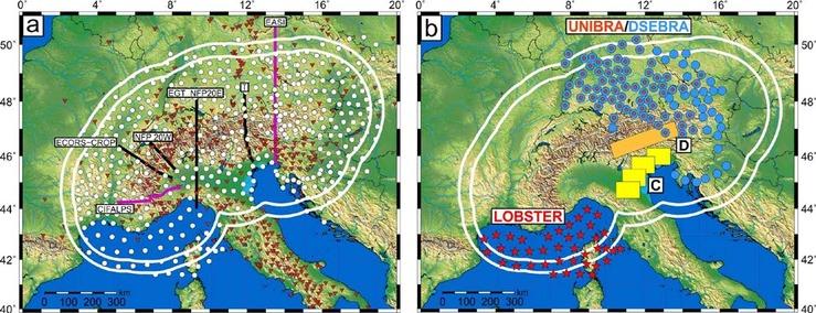
Figure 3: The Alpine domain with seismological experiments: (a) White lines delimit the international backbone network with all 579 broad-band seismometers (red triangles – permanent national stations, white circles – AlpArray mobile stations). Purple lines - AlpArray passive seismic swaths with densified station configurations: EASI – Czech-Austria- Swiss swath, CIFALPS – China-Italy-France swath. Black lines – active seismic experiments of the 1980s and 90s, including T, the TRANSALP profile; (b) German seismometers in AlpArray backbone network: Red-blue circles – UNIBRA later replaced by DSEBRA; Blue circles - DSEBRA; Red stars – LOBSTER; Yellow boxes - mobile swath C; Orange rectangle - swath D with densified station networks.
Timing & targeting of seismological investigations: All international parties in AlpArray have agreed to a strict deadline of autumn 2015 for deploying the broad-band seismometers, including the German parts of the backbone station network (UNIBRA, DSEBRA, LOBSTER). Figure 3b shows the location of German geophysical investigations and of all European partners (Fig. 3a). Whereas the backbone is designed to image seismicity, slab geometry and asthenospheric flow beneath the Alps and its forelands all the way down to the MTZ, the swaths will target the uppermost 200 km at the transition of the Eastern Alps to the Central and Southern Alps; this is where the purported switch in subduction polarity occurs (Themes 1, 3), where crustal and surface responses to this switch are expected to be most pronounced (Theme 2), and where ongoing Adria-Europe convergence is associated with active faulting and the greatest seismic hazard in the Alps (Theme 4). In short, this part of the Alps is an excellent place to study transient orogenic processes on all scales.
Siting of station swaths: Swath C is a mobile station array that will be deployed four times between the Northern Apennines (site of the 2012 Emilia earthquake) across the Po Plain to the Friuli area of the Southern Alps (site of the 1976 Friuli earthquake) in order to target active fault systems along these opposing orogenic fronts and their forelands. It will yield highly resolved seismic parameters (shear-wave velocity, attenuation) and allow us to quantify various site effects, most important, the amplification and extension of ground motion due to 2D and 3D effects, and secondary effects like liquefaction. Swath D is situated along the tip of the eastern Adriatic indenter and covers part of the Moho gap in the Eastern Alps (Fig. 4c) and the slab gap between Central and Eastern Alps (Fig. 4d). It complements the orogen- perpendicular EASI swath of Czech, Austrian and Swiss partners, as well as the TRANSALP section (Fig. 4a), thus providing optimal coverage of structures in the crust and upper mantle that may be related to a switch in subduction polarity and to orogen-parallel motion of the orogenic crust (Themes 1, 3). Swath D will image prominent crustal and lithospheric structures (e.g., Periadriatic Fault System) with unprecedented clarity down to the base of the crust and/or lithosphere, allowing surface structures to be linked with the deeper structures targeted by the backbone (Theme 4).
Location of geological investigations, integrating geology & geophysics: Structural geological, thermo- chronological, petrological and surface studies are planned in areas with thematic focus (stars in Fig. 4b): Active and exhumed fault systems (Stars 1, 2; Themes 3 and 4), exposures of the subduction channel (stars 3, 4; links Themes 1 and 3) and denudational studies above areas of possible slab polarity switching and tearing (stars 5, 6; links Themes 1 and 2). All of these studies will complement geophysical imaging, especially along the profiles and swaths (Figs. 3, 4) as outlined below. It is emphasized, however, that geological investigations must extend beyond the narrow confines of the swaths simply because surface structures suited for studying mountain-building processes do not everywhere coincide with the younger structures at depth or with the logistical constraints of station deployment.
Overall schedule: 4D-MB will require 2 three-year funding periods starting in 2017 (Table 1). If the program is funded, a first round-table meeting will be organized immediately to update the goals and workshops will be organized on the research themes and activity fields. The 1st year of 4D-MB will be devoted to deploying seismic stations, employing young scientists and acquainting them with the newest methods, data and research. Harmonization and coordination of available data as well establishment of infrastructure for management and data-handling will be another essential part of this 1st phase (below and section VI). During the 2nd and 3rd years, scientific work will be accompanied by annual round-table meetings to inform all 4D-MB participants and international AlpArray partners of new results and to identify potential problems. Towards the end of the 2nd year, proposals for specific sessions at international congresses will be submitted. During the 3rd year, initial results will be published in a special volume of an international peer- reviewed journal. Already at this point, plans for the 2nd phase of 4D-MB (2019-2022) will be discussed and goals will be adjusted to fit the newest needs and challenges, and to ensure coordinated submission of proposals.