Groundwater
| Raindrop A ... | Raindrop B... |
|
... infiltrates the soil, reaches the water-table and becomes groundwater.
|
... falls directly into an upland lake, becoming surface water.
|
The table above demonstrate possibilities of a water drop changing from surface water to ground water and vice versa, or evaporating into the atmosphere.
An entirely distinction between surface water and ground water is not possible considering the processes of the hydrologic cycle, but depending on the time considered, clear separation is possible.
Groundwater recharge needs more attention at, since it reduces surface water runoff, erosion risk but increases water availability during dry seasons.
The figure above is highlighting major ground water flows – from groundwater recharge to ground water utilisation. Ground water generally must seen as a whole system across large areal extend; Activities in one can affect the groundwater table in several ten kilometres distance.
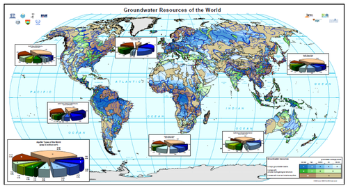
Global ground water resources
Image Credit: BGR Hannover / UNESCO Paris, 2008 http://www.whymap.org/whymap/EN/Downloads/Global_maps/whymap_125_statistics_pdf
The global groundwater resources are displayed in the figure below. In many parts of the world huge groundwater resources are available, only the large arid zones (Sahara, Central Asia, parts of Australia and southern Africa) have limited groundwater resources. However, groundwater is used to a wide range of different intensity due to high investment and running costs for exploration and withdraws.
The global freshwater use differentiated by sectors clearly show, that freshwater consumption is not strongly correlated to groundwater availability, but is much more depending on surface water.
The challenge for IWM is the fact that ground water is not having the same hydrologic boundaries that surface water (watershed) and thus, subsurface trans-boundary ground water occurs – with regard to the surface boundaries of a defined watershed area.
Due to the fact that in most areas only little is known about groundwater occurrence, flow, quantity, and recharge activities of IWM towards groundwater are commonly kept out – scientifically wrong, but practically done, since it easy the hydrologic assessment processes.
But knowledge and sensitivity about groundwater utilisation needs attention at, since only few percentages of groundwater available are used for consumption.


